01. Hanksville to Hite
Gauge Conditions
Runnable: 100.0 – 1,000.0 CFS
Data from American Whitewater & USGS
Run Map
Run Time Estimate
Select put-in and take-out to estimate time.
Plan This Trip
See wind-adjusted speed maps, forecast planning, and detailed time estimates.
Sign in to generate an AI timing estimate for this run.
Whitewater timing varies with scouting, portages, and group pace. Use as a planning baseline.
Description
The Dirty Devil offers a wilderness float trip with incomparable scenery and side canyon hikes. Floatable flows occur in the late winter through early spring (mid Feb - mid March) and during late summer thunderstorms.
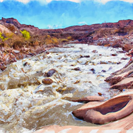
Fremont River and Muddy Creek join together at Hanksville to become the Dirty Devil. Most of the dirt seems to come from Muddy Creek. Most of the water is taken out for agriculture and domestic use before it reaches the confluence and put in. Flows at the start will be almost always very low. Side streams below the put in will gradually add water and make floating easier as boaters proceed downstream.
Standard Put in:
Somewhere near the confluence. AW does not have good information about upstream put in options. Study the map and ask around when you arrive. Elevation is approximately 4240 feet above sea level.
Standard Take Out:
While Lake Powell is low, there is a river runners take out on the north side of the lake, just downstream of the Dirty Devil confluence. There appears to be plenty of parking. Boaters coming out of Cataract Canyon sometimes end their trips and derig at this take out, so it could be busy. Hite Marina proper is on the south side of the river/ lake. Elevation is approximately 3600 feet above sea level.
Character:
Especially near the beginning, the river is wide, shallow and braided. Expect lots of boat dragging unless you get good flows. Boats with very shallow draft are most suitable, but canoes, inflatable kayaks, inflatable canoes and recreational kayaks have all been used. The canyon is also very wide in the beginning, but it gradually becomes narrow. Near the end, the river cuts down through Lake Powell silt. The channel can be very narrow with swift water. The overall gradient is about 8.5 feet per mile.
Packrafting:
The Dirty Devil offers numerous packrafting options including Angel Point to Burr Point, Burr Point to Poison Spring, and a Lake Powell to Fiddler Cove loop via the Hayduke Trail and the Red Benches. Each is best run as a three day trip to take advantage of the numerous side canyon hikes. 100 cfs or more is needed for a trip with moderate packraft dragging (e.g. every 10-15 min). The “Dirty Devil Daily” is a great introduction to DD packrafting using the north side access road by the DD bridge on Lake Powel. Please turn off geo tagging and refrain from posting trip details to keep these trips both wild and an adventure.
Other Information Sources:
Hanksville BLM office, at the intersection of highways 95 and 24. Phone 435-542-2361
Dirty Devil Float trip by Rich Henke, March 2005
Dirty Devil report by Gerald Trainor, 2008
Test edit by Bethany
Rapids in this Run (1)
Difficulty
Class I
Length
84.2 mi
Gradient
9 ft/mi
Rapids
1
Access Points
Difficulty Classes
I Easy
II Novice
III Intermediate
IV Advanced
V Expert/Extreme
VI Unrunnable
Current Conditions
5-Day Forecast
Whitewater data from
American Whitewater
American Whitewater