02. Smokey Bear to Rainbow Gardens (The Narrows)
Gauge Conditions
Runnable: 130.0 – 1,600.0 CFS
IV- Laps on the waterfall section are pretty clean at 200.
Data from American Whitewater & USGS
Run Map
Run Time Estimate
Select put-in and take-out to estimate time.
Plan This Trip
See wind-adjusted speed maps, forecast planning, and detailed time estimates.
Sign in to generate an AI timing estimate for this run.
Whitewater timing varies with scouting, portages, and group pace. Use as a planning baseline.
Description
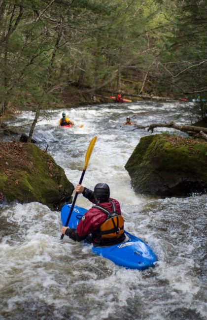
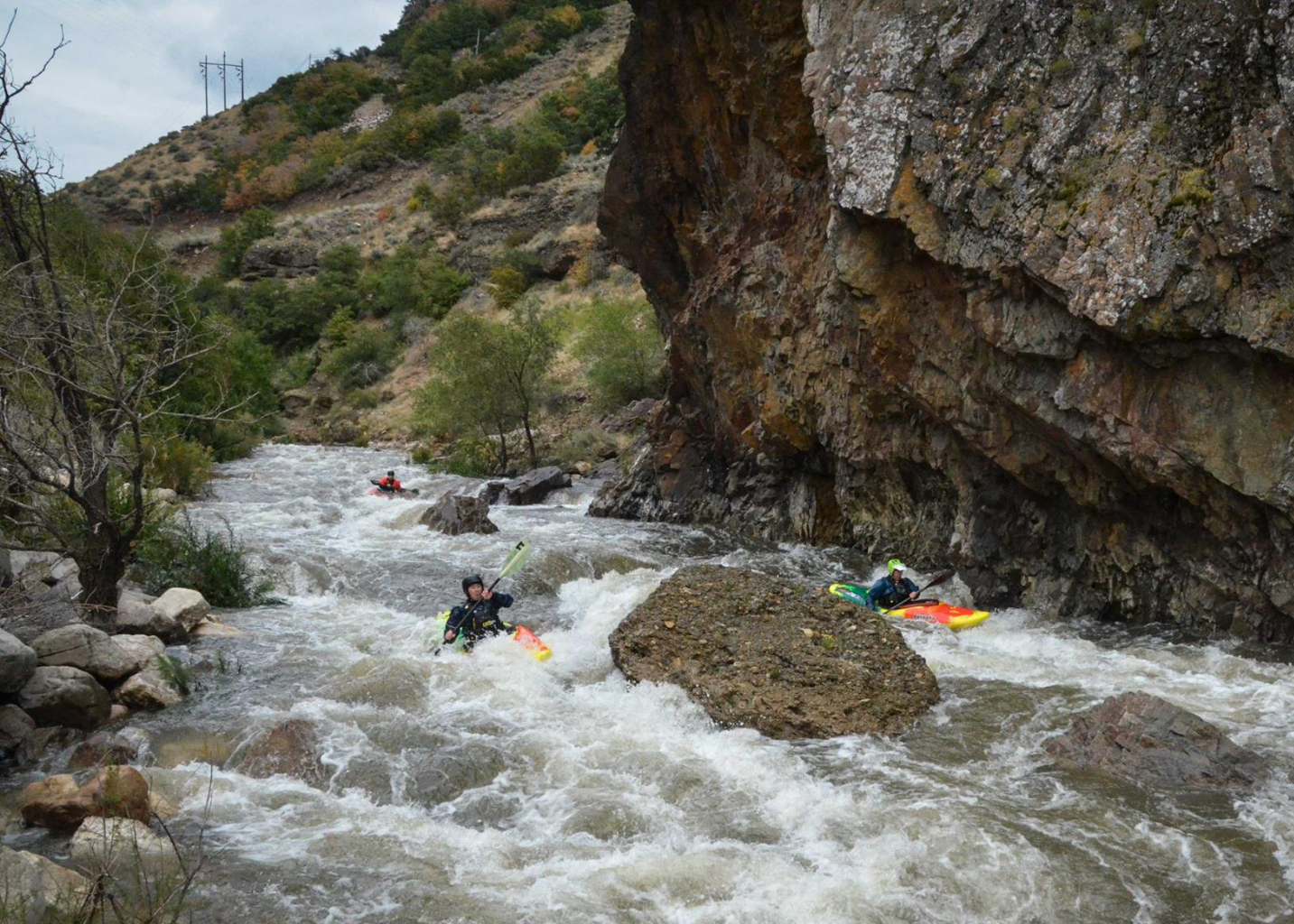
The Narrows: From the Smokey Bear sign putin (across from the Indian Trail trailhead), you get some class 3 to warm up on. The Green bridge is the last possible class III takeout, below there are no big eddies, and the drops pick up a little punch as you approach the a drop that is the start of the class 4; sometimes a boof left is possible there. At medium low flows (200-300), it helps to know the line to avoid some FU rocks. The drops are very continuous but relatively clean. A left eddy that is big enough for a few boats along the rock wall is an option, then comes the Wall Drop along the concrete bend. Go left at the wall drop, or have left boat angle at least, then a big left eddy is the best one on this section. Catch your breath, then peel out and focus again! A hundred yards below there is an aerated drop called 'the demon' that is easier on center-left. The right line here can flip you, and there is a rock on the right just below the hole that has caused a pin. Then it eases off a bit, till the waterfall section. This is a fun little section you can hike laps on even at low flows (200). At high water there is a sticky hole under the road bridge on the right wall. Below the bridge, at medium flows, the left bank is undercut. Then you pass the hot springs, which have been fenced off since 2014, there is some good eddy hopping in this section, and then the final 'narrows' choke, a left line at low flows, which is another good place to road scout for wood.
Wood is often an issue and in previous high water years has caused some very close calls for local paddlers. The good news is you can scout the entire thing from the trail on the north side of the river (cross over the foot bridge near the artificial waterfalls at the mouth of the canyon.)
Since this run is roadside, its possible for intermediates to do Rainbow Gardens, then the Pineview section, then do the lowest parts of the Narrows, moving the putin upstream a little bit at a time, to get a feel for the run.
There is a roadside putin just above the hotsprings, for the lowest quarter mile of class 4.
Then putin above the waterfall, either side of the wood footbridge.
You can also putin a quarter mile upstream of the waterfall, although it involves a boat hike, or a roadside putin from a micro parking spot. This is the 'lower half', or 'below the demon' section. This is a popular option at higher flows, such as above 650.
At typical flows its rocky and somewhat shallow, and a full face helmet and elbow pads can be helpful. Take out at either a dirt pull out east of Rainbow Gardens (the parking by the new footbridge is handy, on the 12th street/Canyon Road side), or continue on the class III to the Sports Park, below the Eccles Dinosaur Park.
===
A teacup diagram of the Pineview and Causey reservoir levels can be found here:
http://www.usbr.gov/uc/water/basin/index.html
http://www.usbr.gov/uc/water/basin/index.html#tab-2
100% Storage is 110149 a-f
110745/110149 states 101% full. 1101.49 is 1%, so 111250.49 would be exactly 101% full.
110917/110149, on 6/6/2017.
111119/110149, on 6/8/2017.
Pineview Reservoir can be selected at this link to get 40 day elevation data. The Ogden below Pineview mainly only has spring releases if the reservoir is full, unless there are flood control concerns, as in 2017.
https://www.usbr.gov/rsvrWater/rsv40Day.html
Reclamation, Upper Colorado Region, Water Operations:
https://www.usbr.gov/uc/water/index.html
Locations include dozens of reservoirs in CO, UT, NM Pineview, Causey, Jordanelle, Deer Creek, even Joes Valley and Flaming Gorge, Lake Powell, and many others.
These links changed in April 2016 (and again, updated 2//2017, and again in 2024). Choose Pineview, then you can choose a variety of data, like elevation (reservoir level), releases (this appears to be the piped release to the power plant; it does not include the release into the Ogden river), and inflow. Pineview 'Top of Active Storage' is 4900.0 feet above sea level.
Pineview inflow forecast:
https://www.cbrfc.noaa.gov/dbdata/station/flowgraph/flowgraph\_hc.html?id=PINU1&ptype=2&linear\_flow=0 https://www.cbrfc.noaa.gov/dbdata/station/flowgraph/flowgraph\_hc.html?id=PINU1&ptype=2&linear\_flow=0
Pineview outflow forecast: (not sure what a working link for this is now).
http://www.cbrfc.noaa.gov/station/flowplot/flowplot.cgi?OPDU1
Causey Top of Active Storage is 5692 feet (this feeds the South Fork Ogden).
Utah Snotel Current Snow Water Equivalent (SWE) % of Normal
https://www.wcc.nrcs.usda.gov/ftpref/gis/images/ut\_swepctnormal\_update.png
What is up with this new link?! ha ha
https://nwcc-apps.sc.egov.usda.gov/imap/#version=169&elements=&networks=!&states=!&basins=!&hucs=&minElevation=&maxElevation=&elementSelectType=any&activeOnly=true&activeForecastPointsOnly=false&hucLabels=true&hucIdLabels=false&hucParameterLabels=true&stationLabels=&overlays=&hucOverlays=state&basinOpacity=75&basinNoDataOpacity=0&basemapOpacity=100&maskOpacity=100&mode=data&openSections=dataElement,parameter,date,basin,options,elements,location,networks,baseMaps,overlays,labels&controlsOpen=true&popup=&popupMulti=&popupBasin=&base=esriWsr&displayType=basin&basinType=ut\_8&dataElement=WTEQ&depth=-8¶meter=PCTMED&frequency=DAILY&duration=I&customDuration=&dayPart=E&monthPart=B&forecastPubDay=1&forecastExceedance=50&useMixedPast=true&seqColor=1&divColor=7&scaleType=D&scaleMin=&scaleMax=&referencePeriodType=fixed&referenceBegin=1991&referenceEnd=2020&minimumYears=20&hucAssociations=true&relativeDate=-1&lat=38.848&lon=-107.125&zoom=6.9&autoExport=full,pdf,2,2,P,BL,Utah%20SNOTEL,42.916,36.5678,-108.2676,-115.356
Map of the Ogden watershed snotels
Snotel report for the Ogden watershed snotels
Pineview dam:
https://www.usbr.gov/projects/index.php?id=218
Rapids in this Run (8)
Waterfalls (1)
Playspots (1)
Difficulty
Class II-V
Length
1.4 mi
Rapids
8
Access Points
Difficulty Classes
I Easy
II Novice
III Intermediate
IV Advanced
V Expert/Extreme
VI Unrunnable
Current Conditions
5-Day Forecast
Whitewater data from
American Whitewater
American Whitewater