02. Woodcamp to Third Dam
Gauge Conditions
Runnable: 250.0 – 1,600.0 CFS
350+ is better for putting in at Woodcamp.
Data from American Whitewater & USGS
Run Map
Run Time Estimate
Select put-in and take-out to estimate time.
Plan This Trip
See wind-adjusted speed maps, forecast planning, and detailed time estimates.
Sign in to generate an AI timing estimate for this run.
Whitewater timing varies with scouting, portages, and group pace. Use as a planning baseline.
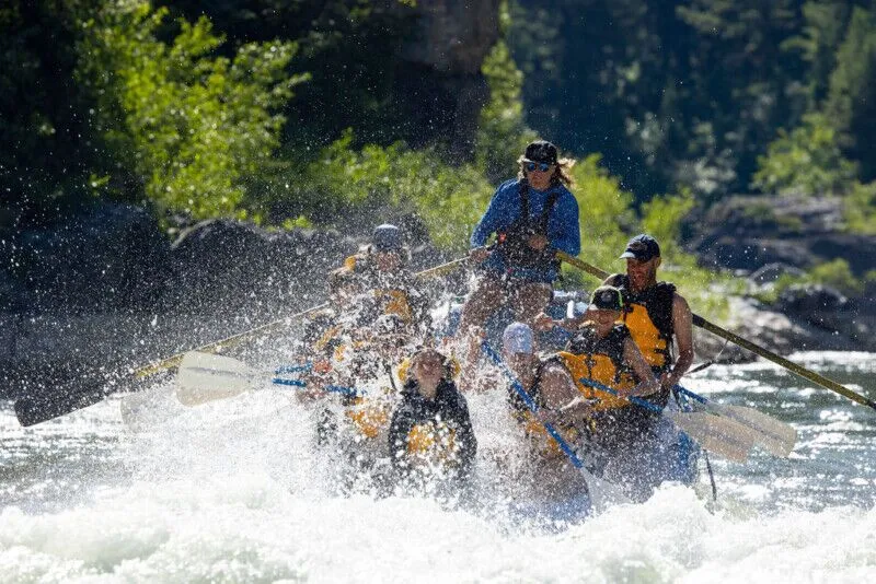
Description
The Woodcamp section is more moderate than the upstream section. The Saint Annes rapid can be done with 200 cfs on the gauge, when much of the river is bumpy low. There is also a fun boulder garden with attainment challenges between Chokecherry and Card day use areas, so a popular low water run is to go from St Annes rapid down to Card.
Above 350, the putin at Woodcamp campground (or just downstream if the riverside campsites are full) is a good putin if you are looking for class III. The 3.2 miles down to Card has the best rapids. There are a couple channel choices, which were free of wood in 2011. You will pass some tall cliffs which include China Cave, which has some very hard rock climbing routes.
There is a nice surf wave after a white footbridge.
After crossing under a green bridge, the whitewater picks up as you approach Saint Anne's rapid, the highlight of the run. There is a small surf wave below there. There are various possible takeouts. If you want to take out at Preston Valley campground, don't park in the campground, park on the road.
From Card to 3rd Dam pond (2.8 miles) is brushier class II. This section is not done as much because of the brush, although it is still scenic. It may have class IV wood avoidance moves. In May 2020 there were no riverwide logs, but a dozen half river logs and log piles. There is a diversion channel that can be followed under the road and back (I saw a swim there because of the brush), or stay left of the road which is the normal, boat-scoutable line.
At higher water above 1100, there may be mandatory roll bridges. Above 1400, there are 3 mandatory roll bridges from Woodcamp to Card, and 3 more from Card to 3rd dam.
===
Other runs on the Logan, moving downstream:
Below 3rd dam is the Bridger section, which is class II-II+. Start at Bridger campground, or the next bridge upstream, and end at 2nd dam pond. There can be a good mellow surf wave in the power plant outflow by the 2nd dam parking lot.
Below 2nd dam is Staircase (IV+), which needs 530+ due to diversions (better above 700). 2nd dam can be run.
Below first dam is the town section. The footbridge diversion drop should be scouted, and maybe portaged. Take out river right; but don't get sucked down the diversion canal. In 2011 you could cross the footbridge and walk a couple houses downstream to a vacant lot that allowed putting back in. There is a good surf wave at the V-wave, from 180 to 350 cfs, then it gets beefier. (2014- The V-wave was affected by a construction project, and now has rocks cemented in the middle of the river, which may affect boatability).
===
Here are some distances measuring from the bridge at the mouth of Logan Canyon, going upstream.
0.0 bridge
2.0 lower 2nd dam - putin for Staircase, IV+, good above 600 cfs.
2.8 Bridger campground, a putin for some class II, good above 300cfs.
3.3 Another putin for the Bridger section, at a low wood bridge that can be a mandatory roll at high water.
3.9 Upper 3rd dam. A bridge to Spring Hollow campground is a takeout for Woodcamp.
6.8 Card day use area. A good takeout for the Woodcamp section at all levels.
7.1 A good attainment rapid at low flows.
7.4 Chokecherry day use area
7.8 Preston Valley campground. A putin/takeout option, but park out on the main road.
8.1 St Annes rapid; with large gravel pullout on right. Best rapid on Woodcamp section, class III.
8.2 pullout on right; possible low water putin for St Annes to Card; ok at 200cfs.
9.0-9.3 China Cave cliff on left. Good putin above 300cfs.
9.7 primitive camping
10 Woodcamp campground. Good putin above 350cfs.
11.2 Monolith rapid, crux of the upper Logan
11.8 pullouts on right with dirt road, primitive camping spot; putin for a short run that includes the white mile, then Monolith, to Woodcamp. 350cfs+ is good, and still decent at 300.
12.9-13.1 more possible putins for Monolith;
Above here is the "wilderness stretch", where the river bends away from the road.
14.8 A IV- slide.
15.3 Ricks Spring, putin right above here to the Upper Logan. Better above 400cfs. Minimum good ~370cfs.
20.1 Red Banks campground. Putin for class III, good above 800cfs. Above here is not paddled much due to private property, possible fences, brush, wood, and braiding. Would probably need over 1200 cfs.
22.4 Franklin Basin Road turnoff on the left. Great primitive camping along the Logan headwaters, and the Steep Canyon run, which rarely has enough water. Continuing up Franklin Basin road:
22.7 First Franklin Basin road bridge.
23.1 Great camping along the creek on the right, for the next few miles.
23.3 Beaver dams
26.6 Second Franklin Basin road bridge.
===
Here is a flow forecast:
http://water.weather.gov/ahps2/probability\_information.php?wfo=slc&gage=lgnu1
Rapids in this Run (1)
Difficulty
Class III
Length
6.4 mi
Rapids
1
Access Points
Shuttle Info
From the mouth of the canyon, Woodcamp is 10 miles upstream.
Difficulty Classes
I Easy
II Novice
III Intermediate
IV Advanced
V Expert/Extreme
VI Unrunnable
Current Conditions
5-Day Forecast
Whitewater data from
American Whitewater
American Whitewater