04. Tacoma to Rockwood Rail Yard (Rockwood Box)
Gauge Conditions
Data from American Whitewater & USGS
Run Map
Description
Update on the Rockwood Train Station:
Covid drove train operations north from downtown Durango to the Rockwood Depot which is the normal place to park and hike. Train operations and personnel have asked for paddlers to not park on their parking lot during business hours (7am-5pm) . They've talked about towing, sheriff etc. New Rockwood operations are still in effect for 2021. We are asking paddlers to respect the parking closure for now to avoid escalating this sensitive access issue. An alternative hike-in exists from Haviland Lake (see the below instructions and detailed photo guide in the gallery courtesty of Nora Flucke).
An alternative hike to the river put in exists further north from Haviland Lake along Hwy 550. Take the exit to Haviland Lake. Drive around the lake and then go right and look for a dirt parking lot. The trail starts at the hiking parking lot and is a pleasant albeit steep trail down to the river. You may want to use a Nav program while hiking due to the many trails that take off left and right. Or ask a local for beta. Better yet, go with a local :) This trail provides another mile or so of paddling with some fun rapids until you get to the Rockwood Box. Please use this during train operating hours. So far no issues have arisen from the takeout hike up to the parking lot. When hiking out, please stay off the tracks through 'the cut' close to the parking lot. You can hike up and over the hill lookers left of 'the cut' on an obvious trail.
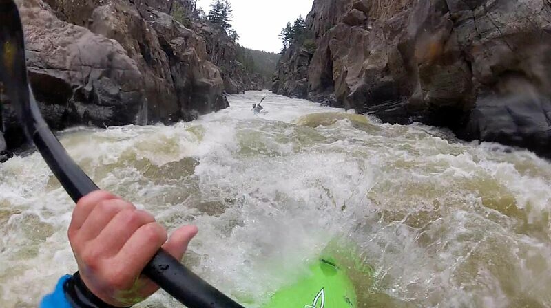
The Rockwood Box is paddled as a continuation of the Upper Animas River and as a quick after work lap for Durango locals.
If you feel you've been pushed to your max on the Upper Animas, consider taking out at the Tacoma train stop. You can catch the last train around 5:30 pm (Check the current train schedule) or if it's already passed your only option is to hike out along the tracks (although this is considered trespassing).
If you arrive at Tacoma hungry for more action, then continue into the box. Just be aware that the rapids become more challenging in this short section and as the canyon walls tighten, opportunities for exit are reduced significantly. In addition, finding the take-out is critical. Past the take-out, the river plunges into the unrunnable Lower Rockwood Box. Missing the mandatory take-out could be terminal.
Though Rockwood does not seem to collect much wood, it is always good to check locally for the latest scouting report on the Box. The Facebook group, Durango River Ralliers is an excellent forum to visit as well as visiting/calling 4CRS Riversports.
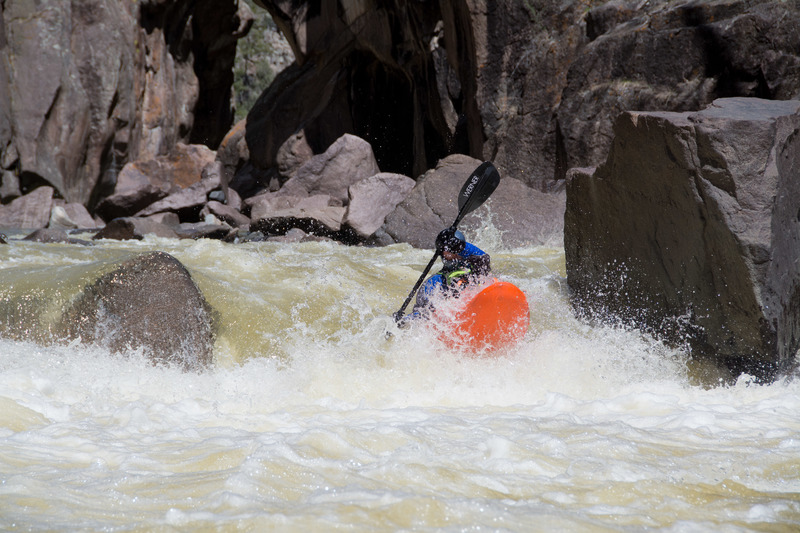
Like most gorged runs, Rockwood's characteristic changes dramatically based on flow. 500 - 600 CFS is super fun class IV paddling. At around 1200 CFS things start to pick up. At 2500+ CFS, the 2-mile section gets its Class V characteristic, the water is moving FAST. Swimming at these levels (even in the high teens) could be bad.
The first rapid in the Rockwood box is known as Mandatory Thrashing by most kayakers and The Guardian by some rafting companies. However, this run is rarely rafted due to the strenuous hike out. At low to medium flows go just right of the large rock that sits just right-of-center. Point your bow with a little left angle and hit a right stroke. It is not uncommon for people to get pushed into the right wall. If you flip, there is plenty of time to roll before the next rip. At medium to high flows run right down the center. This rapid is extremely difficult to scout. From above, you can only see the left lines. At lower flows, the left line goes, not the cleanest boof but it's fun.
After Mandatory there is a lot of fun boogie water. Slicey boats can be a good choice.
Another difficult rapid you will come to is called Red Wall. You can tell you're here when the gorge tightens up, then really opens up. This rapid is a boulder-choked affair with a center to left to center line at low-medium flows. There is a sieve far river left that is not really in play at lower levels but becomes more of a hazard at medium flows and up.
After Red Wall, the river continues straight for about 100 yards, then banks right. This is a neat slide thing at lower levels. Start left, then drop into the curler sideways bracing on your right edge. Fun move.
There is another good rapid after that. At low-med flow, start right then go straight over the boof in the middle. Shortly after, there is a weird pin rock/hole at med levels. It looks like a good boof, but there is a flat rock right in the landing. Go left or right of this.
The next rapid has a super fun boof on river left at low-med flows. At high water, this rapid becomes a river-wide hole.
After this, you can see the large white take-out sign on river right up on the wall a bit. The is the mandatory take-out. Go through the last rapid then eddy out on river right.
!! Whatever you do, do not go past the TAKE OUT sign. Unless you are Spiderman or Superman...
For additional information see: Banks, G. and D. Eckhardt. 1999. Colorado Rivers and Creeks, 2nd edition.
Waterfalls (1)
Playspots (1)
Hazards & Portages (1)
Caution: The following locations may require scouting or portaging. Always check current conditions.
Difficulty
Class IV-V
Length
2.0 mi
Gradient
118 ft/mi
max 120
Rapids
0
1 Hazard
Access Points
Difficulty Classes
I Easy
II Novice
III Intermediate
IV Advanced
V Expert/Extreme
VI Unrunnable
Permit Required
SikBirds
Current Conditions
5-Day Forecast
Whitewater data from
American Whitewater
American Whitewater