1) Carter Creek to Steel Bridge Wild
Gauge Conditions
Runnable: 500.0 – 5,000.0 CFS
Data from American Whitewater & USGS
Run Map
Put-in
Take-out
Rapids/Hazards
Wild
Scenic
Recreational
Description
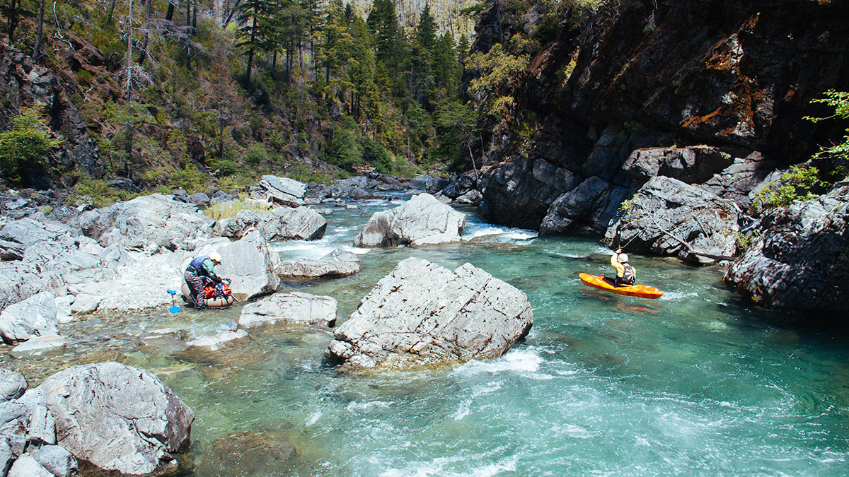
This is the section of the Chetco Wild and Scenic River that flows through the Kalmiopsis Wilderness Area. Access is challenging--involving a 4, 8, or 10-mile hike--but a few groups do this incredible run every year. The advent of packrafts is making this run more accessible to boaters, and there's even a creative but arduous way to do the run as a no-shuttle trip.
Mandatory permits are required to float the Chetco for all users year-round. Free self-issuing permits are available at a boat registration station along the North Bank Chetco River Road (Forest Service Road 1376). This is downstream of the take-out.
An access overview is given at the bottom of this page.
There are two typical ways people do this run:
1\) Low water runs in summer. This style trip became popularized by an Oregon Public Broadcast report. A low or extremely low flows, the whitewater is less difficult (class III with a couple exceptions), but route finding is more challenging. This style of trip is typically done using packrafts or inflatable kayaks at flows well under 1,000 cfs at the USGS gage near Brookings and is considered more of a boat-asssited wilderness adventure than a classic boating trip. This typically involves walking many rapids or portions of rapids that are too low to boat. Some refer to this as boat-assisted hiking. The pools are long, so there's still a fair bit of unimpeded boating involved.
2\) Whitewater boating runs in spring (or very ocassionally in fall) flows. With 1,500 cfs or more at the Brookings gage, the Chetco provides a typical whitewater boating experience. Much of the run can be boat-scouted with a couple exceptions. Portaging is still always an option at 3,000 cfs, a friendly medium flow. 5,000 cfs and dropping is a solid medium flow with some push. Expect a Class IV run with a handful of harder rapids at medium flows. The run is a high quality whitewater trip in a world class setting at these flows. It is suited for all small craft: packrafts, IKs, hardshell kayaks, and even 10-foot rafts.
The Chetco River forecast is a useful tool for estimating flows within a four to 10-day period.
From Chetco Pass, it's a 4+ mile hike down to the river and it's easy to get lost in barren earth that was scarred by the Biscuit Fire. There is no obvious path down and a lot of options. Bring a map, use good judgement, and have plenty of time for a long, hard hike. If you are running this river when it is flowing enough to be good for hardshell kayaks, it is likely you will need to hike in about ten miles via the Babyfoot Lake Trail on the east side of the wilderness area--this is the route commonly taken. A less commonly used but shorter access is on the west side of the wilderness near Vulcan Peak.
Once you reach the river, you'll be in heaven. Everything is pretty much Class III-IV with a couple slightly harder rapids, any of the rapids can be scouted and portaged. This is a spectacularly beautiful river canyon that you'll never forget, and the water quality, clarity, and color is astounding.
Campsites are small and there aren't very many of them until downriver of Boulder Creek, so don't be picky and come prepared to camp in tiny pockets of sand or gravel on boulder bars.
The first take-out is at Tollman Ranch, although very few boaters get out here, opting instead to continue down to the more commonly used and easier take-out just downstream of the steel bridge or at the confluence with the South Fork Chetco. Between the steel bridge and South Fork confluence are the two largest rapids on the whole river, along with a few miles of easy floating. Both of these rapids can be scouted/portaged on the right.
Read a trip report from a 2011 Chetco River Expedition.
Shuttle Directions: The best way to do shuttle is to use a shuttle service (or your own shuttle driver). David Gastineau in Gasquest, CA is a reputable shuttle provider: find him on Facebook. If you insist on setting shuttle for yourself, drive to the town of Brookings and head upstream along North Bank Chetco River Road (784). Just under 16 miles up this road make a left on a gravel road just before the South Fork Chetco River Road crosses the South Fork Chetco. This spur road ends shortly at the confluence of the South Fork and main Chetco rivers (the take-out). An alternate take-out that avoids the final two challenging rapids can be reached by crossing the bridge over the South Fork Chetco and taking an immediate left. Follow this road for 4.2 miles to the steel bridge over the Chetco River. There is no reasonable river access at the bridge itself but a dirt road on river right by the bridge goes downriver about 1/8 mile to a decent access site.
To reach the Babyfoot Lake Trailhead, return to the town of Brookings, head south on Highway 101 to Highway 197 to Highway 199, all the way up the Smith River and into the town of Cave Junction. From Cave Junction, continue north on Highway 199 for 5.4 miles. Turn left onto Eight Dollar Mountain Road/NF 4201 and follow it for 7.2 miles. Then turn left (the name changes to NF 4201) which you will follow for 7.4 miles. Turn left at the “Y” and continue 0.7 miles along the main gravel road to reach the Babyfoot Lake trailhead.
From here you will hike about 10 miles along the Babyfoot Lake Trail and a series of decommissioned roads to reach the Chetco River. When Babyfoot Lake is reached, the trail may disappear for a short while, start by following the rivulet exiting the lake downstream, but staying at roughly the same elevation as the lake as you wrap around the hill on the rivulet-left side of the lake (take care not to get too far downstream) until you meet up with a decommissioned road that you follow (uphill at first) for five miles. You will follow this as it gains then traverses the ridgeline. After five miles turn right and follow this trail/road four more miles down to the put-in at the confluence of the Chetco River and Carter Creek. The trail can be difficult to follow near the Bailey Cabin site, but it is there if you poke around a bit. Bring a map and GPS. The Siskiyou Mountain Club has worked on this trail a lot in recent years, so thank and support them! Their Kalmiopsis Wilderness maps, which happen to be the best and most current printed maps of the area: get their Kalmiopsis Wilderness Area (South Half) map for coverage of the entire Chetco River in the wilderness.
The Chetco River is also accessible via the Chetco Pass Trail. This is commonly used in winter and early spring when the Babyfoot Lake Trail and its road access are snowed in and again in summer when seasonal road access reduces the distance that must be hiked. However, getting to the Chetco Pass Trailhead requires crossing the low water bridge over the Illinois River at McCaleb Ranch. This oddly low bridge will have water sheeting over it when the Illinois River is 2000 cfs at the USGS gage at Kerby. A truck can make it across the bridge with flows of 2,500 to 3,000 cfs and some point above that the bridge goes fully underwater. The much higher hikers' suspension bridge just upstream is officially closed by the Forest Service. Once across the Illinois River at McCaleb Ranch, there is a concrete vault toilet and parking area for hikers. The seasonal gate closure on the narrow 4x4 road to Chetco Pass is there to protect the Port Orford cedar from a non-native pathogen comminly carried in mud on vehicle tires. The gate typically opens June 1st of each year; check with the Wild Rivers Ranger District office for the latest info. Whether hiking the closed road or driving it when open, it's five miles uphill to Chetco Pass. Total elevation gain is about 2,400 feet. From the pass, the only way downhill to the Chetco River is by foot on a four-mile double-track trail that goes to the confluence of Slide Creek and the river.
Other options exist for accessing the Chetco.
When flows are high, expert boaters have the option of reducing the hike to three miles and the shuttle to 15 miles by accessing the Chetco from a hike from Vulcan Peak to boat Box Canyon Creek into the Chetco on the west side of the Kalmiopsis Wilderness. Beta on that access and creek can be found here.
Some boaters have floated the Illinois River into the Kalmiopsis Wilderness to Klondike Creek, then hiked up the creek to access the trail network near Chetco Pass or to boat Tin Cup Creek in to the Chetco.
Rapids in this Run (1)
Difficulty
Class II-IV+(V)
Length
20.0 mi
Gradient
40 ft/mi
max 100
Rapids
1
Access Points
Shuttle Info
Shuttle Directions: The best way to do shuttle is to track down “Bearfoot Brad” out of Gasquet. If you insist on setting shuttle for yourself, drive to the town of Brookings and head upstream along N Bank Chetco River Rd (784). Just under 16 miles up this road make a left on a gravel road just before the S Fork Chetco River Rd crosses the South Fork Chetco. This spur road ends shortly at the confluence of the South Fork and main Chetco rivers (the take out). An alternate take out that avoids the final two challenging rapids can be reached by crossing the bridge over the South Fork Chetco and taking an immediate left. Follow this road for 4.2 miles to a bridge over the Chetco River.
To reach the put in return to the town of Brookings, then traverse the coast range an hour and a half to the east via Hwy 101 to 197 to 199 into the town of Cave Junction. From Cave Junction, drive north on Hwy 199 for 5.4 miles. Turn left onto 8 Dollar Rd/NF 4201 and follow for 7.2 miles. Then turn left (the name changes to NF 4201) which you will follow for 7.4 miles. Turn left at the “Y” and continue 0.7 miles along the main gravel road to reach the Babyfoot Lake trailhead.
From here you will hike about 10 miles along the Babyfoot Lake trail and a series of decommissioned roads to reach the Chetco River. When Babyfoot Lake is reached, the trail may disappear for a short while, start by following the rivulet exiting the lake downstream, but staying at roughly the same elevation as the lake as you wrap around the hill on the rivulet-left side of the lake (take care not to get too far downstream) until you meet up with a decommissioned road that you follow (uphill) for 5 miles. You will follow this as it gains, then traverses the ridgeline. After 5 miles turn right and follow this trail/road 4 more miles down to the put in at the confluence of the Chetco River and Carter Creek. The trail can be difficult to follow near the Bailey cabin site, but it is there if you poke around a bit.
Difficulty Classes
I Easy
II Novice
III Intermediate
IV Advanced
V Expert/Extreme
VI Unrunnable
Permit Required
There is no permit required, but you may want to check in with the Forest Service to get a wilderness permit.
Current Conditions
5-Day Forecast
Whitewater data from
American Whitewater
American Whitewater