1. Dinkey Dome to Dinkey Campgrounds
Gauge Conditions
Runnable: ? – ? CFS
Approximate reading: This gauge is 6.7 miles away on Dinkey Creek. Use as a general reference only.
Data from American Whitewater & USGS
Run Map
Run Time Estimate
Select put-in and take-out to estimate time.
Plan This Trip
See wind-adjusted speed maps, forecast planning, and detailed time estimates.
Sign in to generate an AI timing estimate for this run.
Whitewater timing varies with scouting, portages, and group pace. Use as a planning baseline.
Description
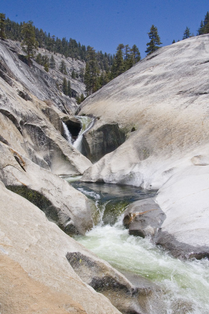
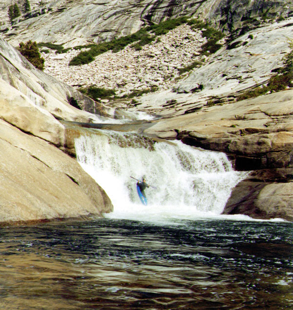
SuperDink is an amazing section of paddling on Dinkey Creek. The first half of the run starts out near Dinkey Dome on granite slabs. The feature destined for greatest renown is the InfiniSlide or SuperSlide, a continuous section of nonstop slides and falls of perhaps 1/2 mile length. The whole section is scoutable on river left and most of it on river right. It is also easy to get awesome photographs of your buddies running these drops. The river right side is cliff near the end.
Between Dinkey Dome and the Infinislide, there is one long but easy portage around a beautiful gorge. The gorge itself appears to have moderate drops within it, but unfortunately both the entrance and exit drops are narrow crevases that appear unrunnable and impossible to portage. If you boat the falls down to the entrance of this gorge, you will probably want help from shore to get out and haul your boat up out of the gorge. Otherwise start walking on the river left slabs above these falls.
In the second half of the run, the creek is less steep but more congested. The creek drops into a forested area and runs through many small gorges of tight twisting drops. It is all easily scouted or portaged, but is frequently boat scouted. It remains solid class 5 for the entire distance. Near the end the creek flows between two domes and there is an unrunnable drop or two. This section can be easily portaged on slabs on left or the individual drops can be portaged with difficulty at river level.
When you see fishermen, campers and cars, you know the end is near. Try to look sharp in the final serious gorge ending at Honeymoon Pool. I have always portaged at least one drop in this final gorge, but the young guys just bomb it. Worth looking at when you leave your car at the take out.
\-\-\-----
Take out: From Fresno, take highway 168 to Shaver Lake. Turn right on Dinkey Creek Road to Dinkey Creek. At Dinkey Creek, bear left through the campgrounds to Honeymoon Pool or to the end of the road a few hundred yards further. In 2002 the campground hosts charged us $3.00 to leave each car at Honeymoon Pool. There may not be a charge if you continue to the end of the road, since it is a trail head. You could also park at the highway bridge and boat the extra mile and a half through the campgrounds Class 3 to 4).
Put-in: Drive back a few miles on Dinkey Creek road towards Shaver. Turn right on Rock Creek Road and follow signs towards the Dinkey Lakes trailhead. This road is deteriorated pavement mixed with dirt and gravel. Eventually it is just dirt and gravel. After a good long ways you will see a valley and Dinkey Dome on your right. There is a turnoff down to an old Quarry at Cow Creek.
Sometimes people park at this quarry and hike or boat down Cow creek. The distance is about .6 mile and about 400 feet of drop over awkward terrain. This puts you at the bottom of the InfiniSlide section, where you can cross to the other side of Dinkey and then hike on the slabs back upstream. Topozone Map - Cow Creek .
.
Alternatively, continue on past Cow Creek to the next road going right. If the gate is open, follow this somewhat overgrown road to its end directly across the canyon from Dinkey Dome. Follow vague trails downhill but upstream to the creek. This gives a number of big waterfalls and also some portages before you get to the InfiniSlide. The distance from the road to the creek is about 3/10s of a mile and down over 400 feet. This is also awkward hiking.
Topozone map - Middle hike
The next possible access is about 1 mile further up the road at a hairpin turn. Park here and hike uphill southeast for .2 mile to a low pass only about 150' higher than the road. Then hike downhill east and then south for .6 miles to the creek. This description is purely based on maps and GoogleEarth, but it appears that this route may have easier hiking than the previous two access routes as well as giving additional boating distance. Topozone Map - Switchback Put-in.
Elevations:
Base of Dinkey Dome; 7120'
Cow Creek Confluence 6420'
Dinkey Campgrounds road end; 5900'
HoneyMoon Pool; 5820'
Season: In 2006 which was a very wet year, flows were optimum about a week after memorial weekend. In several above average water years memorial weekend saw the most boaters. In 2007, a critically dry year, flows were in range from about May 10 to 20th. Snow will usually block road access to this section till late May. In dryish years it may be accessible from early May. In wet years flows and access may require waiting till after Memorial weekend.
see the SierraForest Recreation Report for the most current road and access information
If the put-in roads are snowed in, some boaters have hiked to the put-in. There is a good trail that runs between the end of the road at the campgrounds up to Cow Creek and the Infinislide area. This trail tends to stay a fair distance to the west of the creek, however. Go through the Dinkey Creek campgrounds to the end of the road and park at the trailhead parking area. Topozone map of trailhead Walk west, away from Dinkey creek and up a fire road for a short distance. The trail will branch off and follow a side creek (Rock Creek)that heads back north parallel to Dinkey Creek, but about 1/4 mile to the west. The trail climbs through a low pass and then into the next basin upstream. When Rock creek veers to the west, the trail continues north, parrallel to Dinkey and only a little bit to the west.
Services: Free, primitive camping is allowed almost anywhere in the vicinity. Developed camping is of course available at Dinkey Creek Campgrounds Dinkey Creek Inn offers cabins, showers, and a small store with a resteraunt. Across the creek Camp Fresno offers very rustic cabins at very reasonable prices, but you must typically reserve cabins far in advance. The phone number for both the inn and Camp Fresno is: (559)-841-3435 .
Other river sections in the general area: Dinkey Creek: Dinkey Creek Campgrounds to logging spur road Needs higher flows than SuperDink!
Dinkey Creek, Ross Creek Trail to confluence of NF Kings This needs low flows so can be boated about the same time and a bit later.
NF Kings Above Wishon Reservoir This section may be in boatable range as Dinkey flows taper off
SF San Joaquin, Bridge over Piute Creek to Florence Lake
Granite Creek; Strawberry Mine to near Cassidy Trail is said to run about a week two behind Dinkey.
Rick Smith reported running from the Headwaters down to the SuperDink! section.
"On my second or third descent of Super Dink I hiked in from Dinkey Lakes and ran it from the head waters on down. It has "table" rock slabs that pour over onto low angle sloping ramps, straight shoots, bedrock slides, and boulder chokes It require more water to pad out the drops.. It was fun but in my opinion the quality of the run really begins at Dinkey Dome on down as far as work to paddle ratio goes. I generally stop running "super Dink" whene the guage at North fork below dinkey creek drops below 380 cfts. My favorite levels have been between 420 and 450 cfs at that same guage including the minimal 10 to 15 cfs fish flow comign from the north fork.
Hope this helps,. Rick"
Paul Martzen, 2003
Here is a video of a few rapids above Dinkey dome, the two drops above Infinislide, and Infinislide.

Click To Play
Rapids in this Run (1)
Waterfalls (1)
Hazards & Portages (1)
Caution: The following locations may require scouting or portaging. Always check current conditions.
Difficulty
Class V
Length
3.0 mi
Gradient
360 ft/mi
max 500
Rapids
1
1 Portage
Access Points
Difficulty Classes
I Easy
II Novice
III Intermediate
IV Advanced
V Expert/Extreme
VI Unrunnable
Current Conditions
5-Day Forecast
Whitewater data from
American Whitewater
American Whitewater