1. Greenland/Panthertown confluence to Rock Bridge
Gauge Conditions
Runnable: ? – ? CFS
Approximate reading: This gauge is 10.4 miles away on Tuckasegee. Use as a general reference only.
Data from American Whitewater & USGS
Run Map
Interactive run map
Loads as you approach this section.
Description
Check out Alex Harvey's pictures of this run from Jan. 20, 2002.
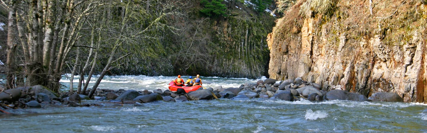
The Upper East Fork of the Tuckaseegee is often overlooked, simply because of the fact that it is located amidst such a plethora of whitewater options. Combined with the run being of an easier nature than the nearby Jocassee runs and having complicated access, there are few people who have boated this section.
Despite this, the Upper Tuck as it is called, makes for a pristine ride through one of the most unique areas in the south. Starting at around 3700 feet, the river winds through a high altitude marsh land, which is surrounded by massive granite domes. The water quality is superb and is tannic bronze, and the flora is delicate, impressive, and endangered. The terrain is quiet yet intimidating, and the whitewater is definitely of the highest quality.
There are two streams to putin on. Panthertown Creek and Greenland Creek are the two options, with putting in on Panthertown involving either a long hike or a really epic shuttle. Putting in on Greenland is the way it is typically done, and the shuttle is around 30-40 minutes each way.
To put in on Greenland, drive from the takeout at Rock Bridge east on 281 over Owens Gap. There is a short cut road on the right once you hit the upper stretches of the WFFB, but I am not sure of the name. Both roads bring you down to Lake Toxaway, and once here, be on the look out for Cole Mountain road on the right. Turn here and proceed 6 miles up to the top of the ridge, where there is a parking area for Panthertown Valley. Put your boat on your shoulder and head west and down into the valley, listening for water and watching for a trail that goes down to Greenland Creek to your left. After putting in on Greenland Creek, enjoy some easy drops followed by the portage of an unrunnable 20 footer called Schoolhouse Falls. After the portage, there is a short distance of flatwater to the Panthertown confluence, where the East Fork of the Tuck is formed.
This information is from Alex Harvey in regards to hiking in from the east and putting in on Greenland Creek:
We putin off the Cole (Cold?) Mountain Rd. Check the NC gazetteer, p52, D3. Towards the end of the road take a left at a gate. Then right at a driveway. At the end of the driveway there is a gravel parking lot under some powerlines. At the beginning of the driveway to the parking lot there is a trail to Greenland Creek and a put in above Schoolhouse Falls. However Greenland is tiny and could be scrapy regardless of the rain. You could putin at the confluence of Greenland and Panthertown Creek and then there will be plenty of water. There is a trail out of the parking lot that links up with Cold Mtn Road after the gate and which eventually winds down towards the confluence. You will cross Greenland creek on an old wooden bridge before getting to the confluence.
To put in on Panthertown, a hellacious shuttle can be run west on 281 then up 107 towards Glenville, then getting on Breedlove Road for a while. This puts you within less than a mile striking distance from the upper putin on Panthertown Creek, just above Granny Burrell Falls. A shuttle bunny is probably the only way to go here, but if you still want to putin on Panthertown, there is a hike in that requires no shuttle from Rock Bridge. It is a solid 4 miles though, so eat breakfast. Actually, compared to other 4 mile hike ins, it is not too bad, and I would equate the overall physical expenditure and task to that of hiking up Upper Big Creek to the putin about 1/3 mile above the iron bridge. The trail is covered in grass, which provides some cushion, and the elevation gain is only around 400 feet total, with the last mile or so being a quick and pleasant downhill drag, and then a smooth flat area when in the bottom of the valley. A good trail map is available at the outfitters on the NFFB in Rosman. I seriously recommend buying one.
Here are directions for the hike: From the crossing of the river at Rock Bridge, take this road up the mountain 0.8 miles until you see a trailhead on the left marked with a nanty forest sign. This is where to park and start your hike. After around 1.3 miles, you will hit the power line Duke Built across the valley. Take the trail that is slightly down and to your left AFTER crossing under the lines. Don't go up the ridge. Next is a mile of meanders and just under a mile of straightaway with a slight rise near the end. After this straight stretch, the trail will turn left (east), and here look for a trail off to the right. There will be burnt wood right at the turn off. Take this, and then bear left at the next fork, 20 yards in. This is a neat bobsled drag session through rhododendron thickets and deposits you on the valley floor on another graveled trail. Go right, and then after crossing a creek you will hit a 4 way intersection. Go straight and from here take the most obvious trail through pine groves until you hit the creek. After crossing to river right, turn upstream and go 100 yards to the pool below Granny Burrell Falls. The trail to the top is right there, and this is a good putin.
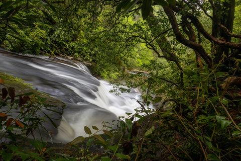
After putting in at Granny Burrell Falls, run the sweet 15 foot class 3 slide and marvel at the top of the world feeling this spot conveys. To the confluence of Greenland is a mile and a half of flat, but moving water. It is great to sit back and relax on this short float, which has a similar feel to the float through Yosemite Valley on the Merced, or Cranberry Glades in WV. Granite domes abound in the background, and interesting plant life surrounds the creek. There is a little bit of limboing and a lot of pushing rhododendron to the side through here. This is the some of the prettiest flatwater around.
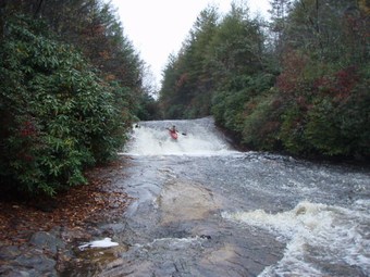
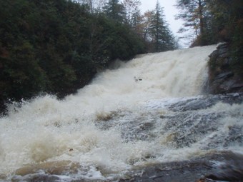
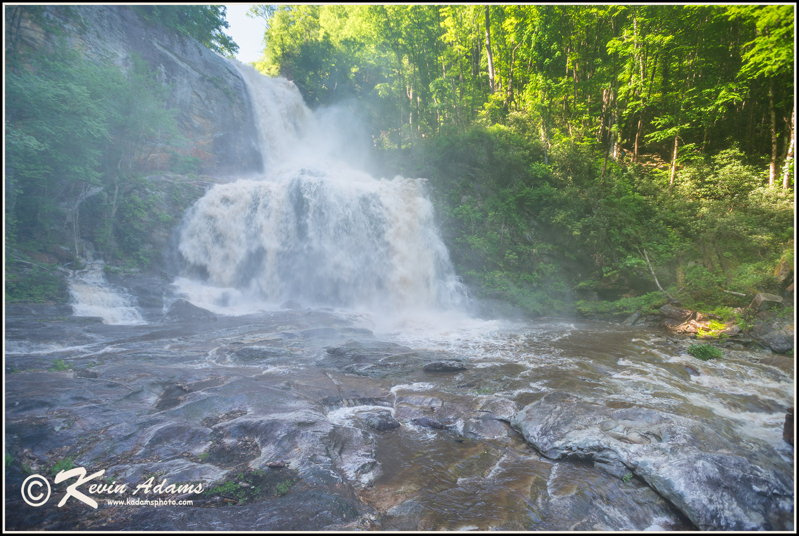
After the confluence with Greenland Creek, the river goes another third of a mile or so before hitting the first and largest drop on the entire run. Upper Warden's Falls is a sight to behold. The river simply disappears over a giant horizon line. The drop is a moderately steep slide of around 45 to 50 feet of vertical drop. It is one of the most fun in the southeast. Other than the obvious danger of flipping over, there is little to no risk in this rapid, and adrenaline will definitely be flowing as you reach the brink. There are some bounces along the way, but all of them are predictable. Scout from the left, after beaching up and crawling through the hells of rhododendron that lace most of this run. Typically, at least at moderate flows, there is not much in the way of banks or eddies above the big drops, so having a good idea of what is coming up is nice.
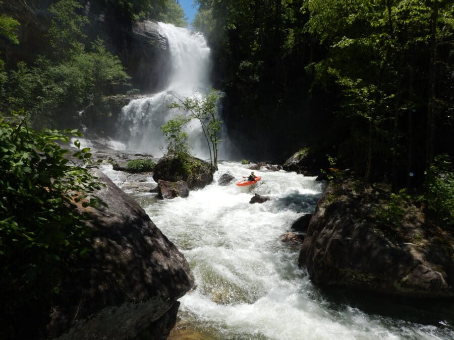
After celebrating below the upper drop, just float around the next bend to Middle Warden's Falls. This is another big slide of around 30 feet of vertical drop. Run it on the right for the easy line, and at higher flows, left of center for a huge planning boof of ten feet. Its high speed, so watch out for local aircraft with radar capabilities. The hole on the left and left-center portion of the drop can be scary with good water, similar to Fowlersville Falls on the Moose. There are no eddies above here, so be ready to scramble if you want a look at it prior to running.
After another bend, Lower Warden's Falls is encountered. This one is smaller, only dropping a total of around 20 feet, and it is low angle. Still, stay center and watch for the rocks at the bottom that could cause some chaos. The far right is undercut below as well.
Soon after a boogie series below Lower Warden's Falls is WWJD, a blind turn into a 6 foot sloping ledge. The ledge is backed up by a bedrock wall which forces a 90 degree turn to the left. The good news is that the ledge is easy to boof and maximum speed can be attained above, as the entrance is swift and flat. The bad news is the hole could kill you. Don't try to turn left early. Drive a big boof way out over and past the hole, and the wall will naturally turn you left with the boil.
As if it couldn't get any better, there is another large slide right around the corner. Elbow Slide is a low angle affair and is the longest slide on the river. It drops around 35 feet, but the first good bit is not steep. Near the end a curl comes in from the right. Take it, as there is a large 10 foot sloping ledge into a powerful hydraulic. Finish left. Now you are deep in the gut of Devil's Elbow.
Some more quality class 3-4 boogie follows, shortly ending in the first substantial boulder garden, Cascade. The walls narrow and a side creek cascades into the gorge from river left. This area is where many boulders have fallen in, and the course is tight. This is the hardest runnable rapid on the river, though there is one further down with much worse consequences. Start center, dropping a tight undercut slot on a big tongue. The river then drives through some diagonal boulders towards the crux. There is a boulder in the middle blocking downstream progress. This boulder divides the river into two channels, a meaty hole on the right, and a thin sneak on the left. Take a look from the left bank, and portaging is also best here, getting in your boat below the cascade and sliding in for the runout drop into the boiling pool below.
The whole run is laced with quality whitewater, and the next ~¾ mile yield nothing but class 3-4 goodness.
At around mile 4.0, the river steepens up immediately after a bedrock slide turning to the right, with a hole on the left. After this drop, eddy promptly right to scout and portage Plinko. This is the one spot on the river that is a mandatory portage. There are two parts. The first is a solid class 4-4+ triple drop with tight spacing and precise lines. The second part is an unrunnable sieve lined with undercuts. There are about 5 giant trees lodged in here, and they are all unavoidable. The first part of the rapid is fine, but the consequences are dire, as the river charges right into the sieve below. Don't be a hero. Portaging is best done on the right. NOTE: the river below Plinko flows through private lands.
After here, the hair is over, but there are still a dozen quality class 3-4 rapids of bedrock and boulder nature. The last of which is quite pleasant. Blood clot is a 5 or 6 foot boof that is clogged with trees. Boof hard and away on the right. This will help prevent getting deflected and stopped by the many trees in the slot. Scouting can be done on the boulder that forms the right side of the slot.
From here it is just a 10 minute float to the takeout through a scenic corridor of class 2 water. Soak it in while you can.
This run is a real classic. It isn't particularly difficult. It is on par with the Watauga, though different in nature. However, the run requires good planning, fitness, a solid crew, and the ability to make excellent personal decisions. These decisions can only be based on a credible and lengthy resume of previous wilderness creek boating. A mistake could be serious, and hiking out once in the Devil's Elbow is simply not an option. Knowing how to read water, use river signals, and run class 4 on the fly are all necessary river skills for this run. Also, practice 'leave no trace' wilderness ethics here. There are many endangered species, and this place is very special. Treated kindly, it will continue to provide a wilderness experience that few other realms in the southeast can rival.
Rapids in this Run (2)

Waterfalls (5)

Hazards & Portages (3)
Caution: The following locations may require scouting or portaging. Always check current conditions.
Difficulty
Class V
Length
4.3 mi
Rapids
2
3 Hazards
Access Points
Difficulty Classes
I Easy
II Novice
III Intermediate
IV Advanced
V Expert/Extreme
VI Unrunnable
Current Conditions
5-Day Forecast
Whitewater data from
American Whitewater
American Whitewater