1. Indian River to North River
Gauge Conditions
Runnable: 2.8 – 8.5 FT
Data from American Whitewater & USGS
Run Map
Description
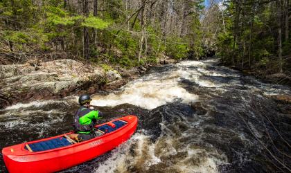
Indian River to North River runs through the remote Hudson River Gorge. Difficulty varies with water levels.
This section of the Hudson is unique in that its release is by way of a tributary, the Indian River.
As of 2025, the releases from the dam on Lake Abanakee happen only on Tuesday, Thursday, Saturday, and Sunday, between May and September.
The Hudson River is runnable without the Indian River release most of the year due to rains or melt. Rafts need the release at put in on the Indian River.
When the Lake Abanakee Dam on the Indian River isn't releasing, one can drive down Chain Lakes Road all the way to the Old Gooley Clubhouse, and put in on a path to the Hudson river.
If the dam is releasing, the trip actually starts out on the Indian River which usually only releases from 09:30 AM until 11:30 AM.
Releases happen only on Saturday, Sunday, Tuesday, and Thursday. Put in about a half mile down from the dam for the normal raft put-in.
There is a great Class IV+ warmup on the Indian (Otter Slide) if you start directly below the dam. Otter Slide has a slightly technical lead-in to a ~10ft drop at low water. During releases, this drop becomes a massive boiling hole. Beware of undercut rocks on river left, the normal line is right of center, where a small amount of water shoots through the hole.
Below Otter Slide, the river is nearly continuous Class III for a mile with a break and then close to a mile of slightly easier nearly continuous class III. The hardest parts of the gorge are harder than the Indian and has no good egress, so if you are struggling on the Indian consider calling it a day. The road is close to the river just above the big island after the 1st rapid on the Indian and you can walk out from the confluence as well. Neither the Indian nor the harder rapids on the Gorge are good places to swim.
The Hudson River Gorge is surrounded by Wilderness Study Areas.
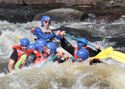
At levels below 4 feet the river is Class III. At levels of 5 feet and above, the river feels like big water Class III+/IV.
Once the Indian makes confluence with the Hudson several rambling rapids welcome you to the Hudson Gorge at the Cedar Ledge.
When cliffs appear on river right be ready for the Narrows. From about 4 to 6' on the North River gauge you can expect the waves inthe Narrows to roughly equal the gauge reading.If the gauge reads 4' you'll find waves about 4' high, and at 6' on thegauge you'll find 6' waves.
After the Narrows is Mile Long Rapid aka Carter's Landing.
The next area has several names and sits in the shadow of Kettle Mountain. Kettle Mountain Rapids aka Givney's.
The Kenyon Eddy is your que to ready for Givneys Rift Rapid (or Soup Strainer). This rapid is characterized by a hard right turn, and it continues for nearly a mile.
```
Then Harris Rift Rapid running along the Northeast side of Harris Mountain finishes in the regions known as Fox Den and Bob Cat Den.
```
```
Above the Boreas River within Harris Rift Rapid are several great surfing opportunities for rafts and kayaks in levels below 5 feet.
```
The confluence with the Boreas River enters river left after a railroad bridge trestle crossing above the river.
The last rapid of the run is Bus Stop - a river wide ledge with a sneak river left. Center route is the stickiest part of this hole, while river right routes slide easy at 2500 to 5000 CFS.
After Bus Stop Rapid are three miles of flatwater to the takeout in the boomin' metro of North River NY on river right.
Use the River Exhibit area to take out.
(updated 7/14/2019)
Google Map of New York Whitewater
New York Whitewater Paddlers Facebook Group
Rapids in this Run (2)
Difficulty
Class III-IV
Length
15.4 mi
Rapids
2
Access Points
Difficulty Classes
I Easy
II Novice
III Intermediate
IV Advanced
V Expert/Extreme
VI Unrunnable
Current Conditions
5-Day Forecast
Whitewater data from
American Whitewater
American Whitewater