1. Mammoth Pool Dam to Mammoth Pool Powerhouse
Gauge Conditions
Runnable: ? – ? CFS
Approximate reading: This gauge is 0.9 miles away on San Joaquin. Use as a general reference only.
Data from American Whitewater & USGS
CDEC Flow Data California
Data from California Data Exchange Center (CDEC)
Run Map
Run Time Estimate
Select put-in and take-out to estimate time.
Plan This Trip
See wind-adjusted speed maps, forecast planning, and detailed time estimates.
Sign in to generate an AI timing estimate for this run.
Whitewater timing varies with scouting, portages, and group pace. Use as a planning baseline.
Description
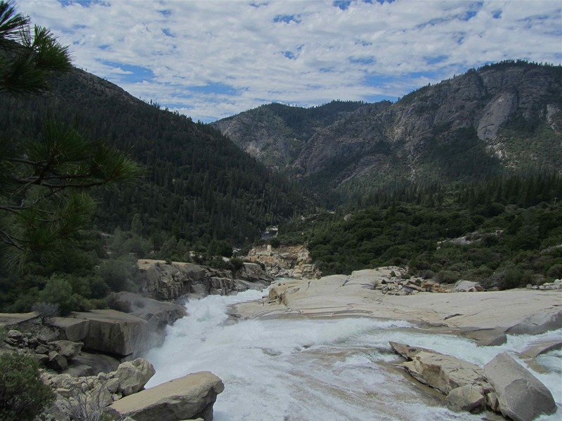
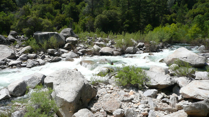
This is another classic section of the San Joaquin River that seldom sees much traffic. The canyon is a deep, impressive, beautiful granite gorge, with 20-30 rapids Class IV or greater. The middle section just below confluence with Rock Creek contains about 1.5 miles of continuous Class IV. Approximately 6 miles into the run the toughest rapid, “Zero to Hero” is encountered. This drop can be portaged on river left by rappelling 30’ to the pool below. TFF is significantly more difficult and serious than Horseshoe Bend but also much easier and less serious than the Chawanakee Gorge.
Boatable flows are available when Mammoth Pool reservoir spills, which happens in 6 out of 10 years according to Southern Calif. Edison. There are no gates on the spillway, so spill starts as soon as the reservoir level reaches 3,330 feet in elevation. In some years prior to spill, up to 1,000 cfs can be released from a valve at the base of the dam. On rare occasions such as the fall of 2011, releases can occur at other times.
Driving Directions: From the south take Highway 99 to Highway 41 north. In the foothills, turn right onto road 200 towards North Fork. Go through North Fork onto Minarets Road towards Mammoth Pool.
From the north, take highway 99 to Madera. Exit at the Millerton Lake - Yosemite turnoff. In Madera turn left onto W. Cleveland Ave, then turn left onto E. Yosemite Ave / highway 145. Follow highway 145 east to highway 41. Turn north and follow the same directions given above.
From Yosemite: Take highway 41 south to the Bass Lake road. Turn left to Bass Lake. Near Bass Lake bear left to the East side of the lake. Continue around the lake to North Fork, then turn left on Minarets Rd. Alternatively, if going directly to or from Mammoth Pool, it may be somewhat faster to take Beasore Rd, to Grizzly Rd, which ends at Minarets Rd about two miles from Mammoth Pool Road.
Take-Out: Drive east or Minarets Road about 14 miles from the town of North Fork, then turn right onto forest service road 8S03. (if you see Clearwater ranger station, you have gone too far) Drive 3.5 miles down this steep and very windy road to the Mammoth Pool Powerhouse. Park in a large area near a gated bridge. Stairs next to the bridge, lead down to the water. The relatively small dam 6 reservoir catches the water from several powerhouses and diverts it through tunnels to the next powerhouse at Reddinger Reservoir. This is also the put-in for Chawanakee Gorge.
Put-in: Return up 8S03 to Minarets Rd and continue east on Minarets Road about 25 miles to the Mammoth Pool Road. Turn right on Mammoth Pool and after 2.5 miles turn right onto Rd 6S25 which leads to the dam spillway area in about 3 miles. Cross a bridge over the spill way, then carry boats down a gated access road towards the river. This road leads to the base of the dam. The easiest put in will be fairly near the outlet tunnels in the dam. Give yourself 1.5 hours driving time between take-out and put-in. Access to Mammoth Pool is closed from May 15 to June 15, to protect a deer migration route across the reservoir. (The closure is for any boat traffic on the reservoir and does not restrict walking to the river or boating on the river.) During this period boaters can access the put-in by walking about 3 miles on the road from where it is gated.
During the winter and early in the spring, the Minerets Rd. is usually blocked by snow just past the Mile High Curve. But, the road is almost always open to the Mile High Curve. When this happens there may be several access options. A spur road descends towards the river near Rock Creek. If you can access the river at this point you can paddle the last half of the run. The Mile High Curve is only about one mile from the river in a straight line. Unfortunately, it is also a 2,500 foot drop over steep and rough country. But, if a reasonable hiking route can be found it would create an all year access and even eliminate a big part of the shuttle drive. Looking at topo maps and aerial photos of area between Mile High Curve and Mammoth Pool, it appears that the most probable route is to proceed north from the mile high viewpoint to near Shakeflat Creek. Then contour around to the east side of the creek and follow the easiest terrain down to the roads.
Federal Energy Regulatory Commission ( FERC) links related to the Mammoth Pool Project, FERC project No. 2085 This project was originally licensed on Dec. 30, 1957. The license expires on Nov. 30, 2007. The renewal process can be very long and has been ongoing for this project (and several others) since 2000. The generators at the Mammoth Pool powerhouse have a rated maximum capacity of 150,938 Kilowatthours.
Search for FERC documents related to Mammoth Pool at http://elibrary.ferc.gov/idmws/search/fercgensearch.asp
In the Docket Number box, write P-2085-\* to do a wild card search for any documents related to Project 2085.
Other Information Sources:
Darin McQuoid Photography - TFF
Austin Nickel Video
http://www.awetstate.com/Video\\kayak55.html
Sierra National Forest road conditions Look at Minarets Road.
Sierra Vista Scenic Biway Map
A GUIDE TO THE BEST WHITEWATER IN THE STATE OF CALIFORNIA, HOLBEK & STANLEY, 1988
Rapids in this Run (4)
Hazards & Portages (2)
Caution: The following locations may require scouting or portaging. Always check current conditions.
Difficulty
Class IV-V
Length
9.0 mi
Gradient
93 ft/mi
Rapids
4
2 Hazards
Access Points
Shuttle Info
Mammoth Pool Reservoir will be snowed in during the winter months. Minarets Road will generally open up during the spring, but heavy snow on the road will delay the opening. The take out at Mammoth Pool Powerhouse is generally open all year round.
[Sierra National Forest road conditions](http://www.fs.fed.us/r5/sierra/recreation/recreports/roads.shtml) Look at Minarets Road.
[Sierra Vista Scenic Biway Map](http://www.fs.fed.us/r5/sierra/recreation/scenicbyways/sierravista-map.shtml)
Difficulty Classes
I Easy
II Novice
III Intermediate
IV Advanced
V Expert/Extreme
VI Unrunnable
Current Conditions
5-Day Forecast
Whitewater data from
American Whitewater
American Whitewater