1. Moshier Section
Gauge Conditions
Runnable: ? – ? CFS
Approximate reading: This gauge is 3.1 miles away on Beaver. Use as a general reference only.
Data from American Whitewater & USGS
Run Map
Run Time Estimate
Select put-in and take-out to estimate time.
Plan This Trip
See wind-adjusted speed maps, forecast planning, and detailed time estimates.
Sign in to generate an AI timing estimate for this run.
Whitewater timing varies with scouting, portages, and group pace. Use as a planning baseline.
Description
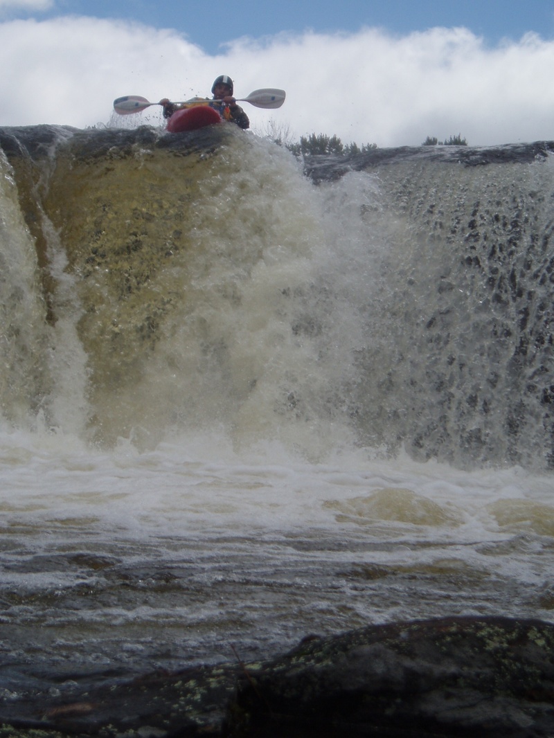
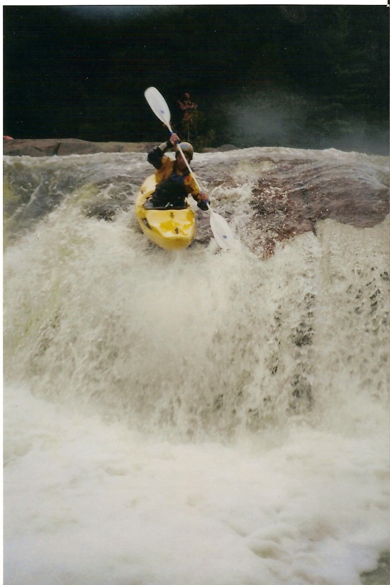
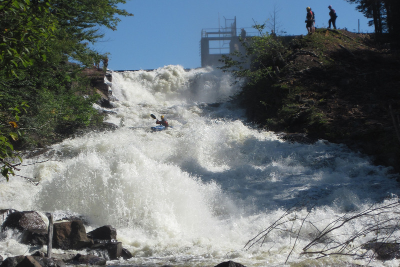
This is the jewel of the Beaver. It begins with a couple of easy waterfalls, followed by some technical rapids; the last rapid, Moshier Falls, is a long, technical Class V. Moshier Falls is easily accessible from the takeout, which yields quite a number of spectators with cameras and video cameras. It's a serious rapid, with body-beating rocks and an undercut cave. The trail on the right does double-duty as a portage route and an attainment trail for those who want to rerun it.
Also see the Taylorville Section (Class III), and the Eagle Section (Class V), both of which run on weekends in September. See also the Raquette (Stone Valley) Section(Class V), which has two releases on Labor Day weekend.
The Beaver River originates from Stillwater Reservoir in the western section of the Adirondack Park northeast of the village of Lowville. The area is undeveloped and camping is available throughout the area.
Terrific campsites are available at the Soft Maple Campground centrally located between the Taylorville and Eagle runs. Boaters also often crash at the Moshier put-in. However, camping at the Taylorville put-in is no longer permitted after reports of public nudity and midnight low-water descents of the drops at Taylorville were brought to the attention of Orion.
Hazard Warning!
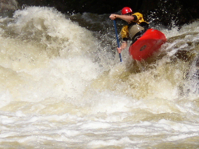
Moshier Falls, the last rapid on this reach, has a very nasty sieve on River Left. Just downstream of the boater in the photo above, a paddler got sucked under a rock on Aug. 31, 2003. Quick action by boaters with ropes helped stabilize him and get him out of the hazard. Moshier Falls is no place to swim!
Posted by Chris Koll:
The releases are a product of negotiations by American Whitewater that resulted in a series of 11 whitewater releases during a typical year spread over three challenging sections of Beaver River whitewater. The sections are dry except for release days when Orion Power allows water to spill back into the natural river bed creating whitewater runs ranging from class 3 to class 5.
The runs are typically short--varying in length from one to four miles--and on most release days water is scheduled on two different parts of the river. Boaters can easily paddle one section of the Beaver in the morning and then catch a second section in the afternoon.
The whitewater sections include the Taylorville run, a 1.5-mile stretch that features six class 3-4 drops. While some of the drops appear intimidating--particularly a steep 30-foot slide--the rapids are fairly straightforward and are appropriate for strong intermediate paddlers looking for an introduction to steep creeking.
The Moshier section is the jewel of the river--a 4-mile run that includes two runnable waterfalls, a number of easy class 3 rapids, and concludes with a long, technical class 5 rapid composed of four discernible drops. The section is appropriate for experts or strong intermediates with judicious scouting and/or portaging.
The Eagle section is short and demanding. Only a mile in length, the run starts off with four class-5 drops where the river drops the equivalent of 475 fpm. Eagle is a demanding expert run.
Questions regarding the Beaver can be directed to Chris Koll by email or by calling 315-652-8397.
Tug Hill - Old Forge Area Reaches
Beaver (1. Moshier)Beaver (2. Eagle) Beaver (3. Taylorville)
Black (1.) Black (2.) Black (3.)
Black (4.) Black (5.) Black, S. Branch
Cincinnati Creek Crystal Creek Deer River (Section 1)
Deer River (Section 2) Fish Creek, E. Branch Independence River (1. Upper)
Independence River (2. Main) Indian (S.Br. Moose trib.) Little Black Creek
Little Woodhull CreekMad River Mill Creek
Mohawk (1.) Moose (1. Middle) Moose (2. Lower)
Moose (3. Bottom)Moose, Middle Branch Moose, S. Branch (1.)
Moose, S. Branch (2.) Negro Brook Otter Creek
Roaring Brook (Brokeback Gorge) West Canada Creek (1.) West Canada Creek (2. Ohio Gorge)
West Canada Creek, S. BranchWoodhull Creek (Upper) Woodhull Creek (Middle)
Woodhull Creek (Miracle Mile)
Google Map of New York Whitewater
New York Whitewater Paddlers Facebook Group
Rapids in this Run (2)
Waterfalls (2)
Hazards & Portages (1)
Caution: The following locations may require scouting or portaging. Always check current conditions.
Difficulty
Class IV-V
Length
2.0 mi
Rapids
2
1 Hazard
Access Points
Shuttle Info
**Directions** (see the [stylized Beaver map](http://www.americanwhitewater.org/content/Photo/detail/photoid/8721/) or the [Google Map](http://maps.google.com/maps?f=q&hl=en&q=Lowville,+ny+to+43.871168+N,+75.136871W&ie=UTF8&om=1&z=11&ll=43.819666,-75.330505&spn=0.209072,0.468292)):
Most boaters will reach the Beaver via Interstate 81 north of Syracuse, NY.
Exit I-81 at Adams Center and take NY 177 east to West Lowville.
At that point, take NY 12 to Lowville.
In Lowville, just South of where Rte. 12 breaks off from Rte. 26 to the Left, turn Right onto Number Four Road.
Follow Number Four Road about 18-20 miles to Number Four. Turn Right onto Stillwater Road.
After about 2-3 miles, take a Left onto Moshier Road. At the end of Moshier Road is the **takeout**.
Just before the end of Moshier Road, bear Right onto the dirt road. Follow it about 2 miles to where you see the gigantic water pipes. Park in that area along the road, cross under the pipes with your boat, and follow the path down to the **putin**.
Difficulty Classes
I Easy
II Novice
III Intermediate
IV Advanced
V Expert/Extreme
VI Unrunnable
Current Conditions
5-Day Forecast
Whitewater data from
American Whitewater
American Whitewater