1. Natural Bridge to Woodruff Bridge
Gauge Conditions
Runnable: 300.0 – 1,500.0 CFS
Data from American Whitewater & USGS
Run Map
Description
This run is best in the summer when all else is too low. The spring-fed water is cold and clear all year long most years and the run is more fun at low water. In the winter you can drag your boat down a mile of snow and throw it into the icewater, but just try to get back to the highway from Woodruff Bridge. The run features a chance to show off before amazed spectators, a chance to scare your pants off, a probable back-flip, a rugged portage, a collapsed lava tube so narrow I saw a Stubby get stuck sideways, and a too easy runnable waterfall. This run is too short. Make sure you are confident where the portage is. If it is not obvious from the description and map you can walk the nice trail on river left first.
Description:
Unload at the Natural Bridge Viewpoint parking area. Be quick and discrete as boating is discouraged here. There are a couple ways to get your boat to the water, but both start with walking down the paved tourist trail. One way is to cross the foot bridge, hop over the stone wall, hump downstream through the woods and scramble down to put in on river right. Some people also do a river left seal launch underneath the footbridge, but this is discouraged if there are tourists around.
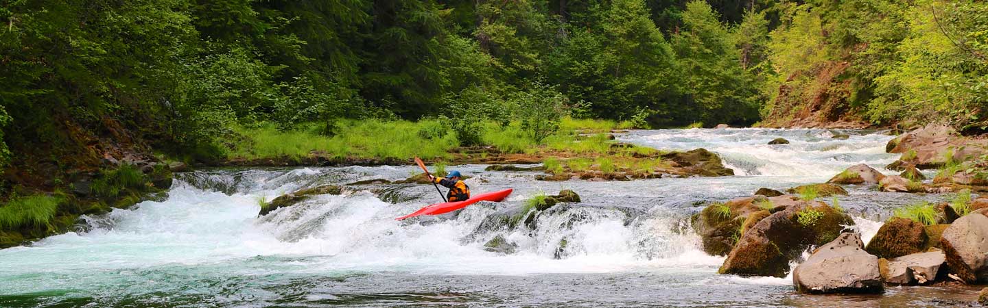
The class V rapid above the footbridge has been run but beware of the cave on river left. At the river right launch there's a class IV- drop then for the first mile plenty of fun whitewater. Don't forget to look up at the colorful rock formations and mature forest. When you come to a short pool at the top of a IV- drop with a couple of moderate-sized boulders it is time to wake up. Go ahead and run this drop and eddy out to scout Karma (class IV).
The next rapid, Karma, is the crux rapid. Karma is a long, steep, rocky rapid that continues around a blind left turn and should be scouted (left). Once you commit there are few/no eddies until you come out the bottom. There are possible lines on the left, center and right, each of which might be better at a certain flow. There is an easier blind horizon below Karma and then the gradient eases up.
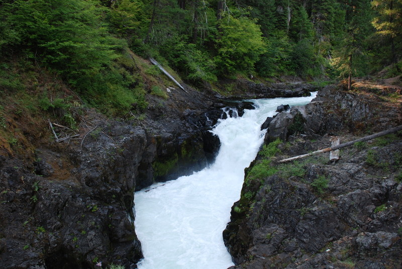
Soon after Karma you come to a pool on a hard right bend, and then a long left bend. The portage trail for knob falls is a short distance around the left bend. If it is your first time down you might want to stop at the pool to scout and make sure you don't miss that last left eddy. Knob Falls aka Therapy Falls (class V) is typically portaged, and it is located at the apex of the bend back to the left. The portage route is on the left, up a soapy dirt slope with roots for steps and handholds, then down bedrock to a 10' seal launch, or farther over another ridge to a lower launch. The falls has been run but some who used to run it don't anymore. There have been some close calls there, so a good safety net is advisable if folks decide to run it.
Below the gorge there are a couple fun rapids finishing off with an unavoidable hole in a narrow chute that may be easiest to punch on the right. At this point the pace slows down considerably.
After a mile or so of flat water you come two collapsed lava tubes that form narrow chaotic slots. The second can be scouted for logs from the take-out before starting or it can be sneaked on the left. The narrow slot on the right is more fun though, so scout.
The last drop is within view of Woodruff Bridge. Find the small blind channel on the far river right and follow it to the final horizon which is an easy auto-boof. If you were to run the left channel you'd go over a falls into a narrow gorge which could result in death in full view of all the fishermen.
Take out on the rock shelf river left underneath Woodruff Bridge. Downstream from this access is a mile of flatwater before the class V Takelma gorge. The river trail (river left) provides good scouting opportunities for 3 of the 5 major rapids in the gorge. It is a 3 mile round trip hike to see Takelma gorge, for those who are considering it.
Logistics:
Take-out: Go north (on Oregon State Highway 62 East) past Prospect. At Highway 62 mile 51.3 turn left on USFS 68 toward Woodruff Bridge. Go 1.8 miles, cross the bridge and park.
Put-in: Go back to Highway 62. Turn left go three miles to the Natural Bridge Campground turn-off (Highway 62 mile 54.9). Turn left and follow the signs to the Viewpoint (0.7 mile from highway). Before you carry your boat down the asphalt 'trail' and over the foot bridge, walk all around and gawk at the natural bridge.
Rapids in this Run (1)
Waterfalls (1)
Difficulty
Class III-IV
Length
3.2 mi
Gradient
42 ft/mi
Rapids
1
Access Points
Shuttle Info
**Shuttle:** [Road Map](http://www.americanwhitewater.org/photos/?photoid=2182)
To get to the take-out: Go north (on Oregon State Highway 62 East) past Prospect. At Highway 62 mile 51.3 turn left on USFS 68 toward Woodruff Bridge. Go 1.8 miles, cross the bridge and park.
Scout: Cross Woodruff Bridge to river right. Turn right, and at MP2 (a hundred feet) turn right onto 6800-300. Bear left at the fork and then turn right onto 6800-304. Go to the end and check out the tube. This is also a fine camp spot.
To get to the put-in: Go back to Highway 62. Turn left go three miles to the Natural Bridge Campground turn-off (Highway 62 mile 54.9). Turn left and follow the signs to the Viewpoint (0.7 mile from highway). Before you carry your boat down the asphalt 'trail' and over the foot bridge, walk all around and gawk at the natural bridge.
Difficulty Classes
I Easy
II Novice
III Intermediate
IV Advanced
V Expert/Extreme
VI Unrunnable
Current Conditions
5-Day Forecast
Whitewater data from
American Whitewater
American Whitewater