1. Route 1987 (Randleman) to Route 2221 (Cedar Falls)
Gauge Conditions
Runnable: 1.2 – 4.5 FT
Can be a boney run. Only consider this range if flows peaked above this and are now holding. Common in summer.
Data from American Whitewater & USGS
Run Map
Run Time Estimate
Select put-in and take-out to estimate time.
Plan This Trip
See wind-adjusted speed maps, forecast planning, and detailed time estimates.
Sign in to generate an AI timing estimate for this run.
Whitewater timing varies with scouting, portages, and group pace. Use as a planning baseline.
Description
The floatable section of the Deep River begins below Randleman Lake, the river generally a flatwater float, but a few notable rapids exist sporadically. This run previously started just below the low-head dam above Worthville Rd (Route 2128), thus excluding 2.2 miles from the presently described run. To hit every major rapid, a nice ledge is found 300 yards upstream from the Main St. put-in, accessed by walking some foot trails connected to the greenway on the southern side of the river. I have dubbed this bigger rapid "Peter's Ledge" after the original mill owner. One more ledge rapid just above E. Naomi St, then the paddling gets flat and peaceful again and remains that way until the rapids at Cedar Falls (except for portages around dams....described below).
The Deep River suffers greatly from the stifling number of dams/weirs every few miles. There are three on this section and all are unrunnable to my knowledge. The first is found just upstream from Worthville Road at mile 2.2 and can be portaged on either side. The second is at mile 6.7, found off the end of Franklin Dr. The last dam is at 8.0 miles, found near James Ray Drive in Cedar Falls and should be portaged river left.
Cedar Falls "Park n' Run" Whitewater Subsection- This is a micro-run, but it's fairly easy to access, and has some good features for the central piedmont. The run is only about 2000 feet of flow but drops 30 feet during it's course. Customary to "ledge" rapids, there are often multiple lines with completely different personalities from one side to the other, and dramatic changes as flow increases. This is a great spot for diverse paddling groups, as you can run it multiple times in different ways, do some playing, with good variety depending on river level. Honestly, I'm surprised that more people don't frequent this section (BLP).
Approach: Despite posted signs along most of the riverbank, fishermen and paddlers regularly park on the dirt/gravel pull-in near the Loflin Pond Rd / Cedar Falls Rd intersection. There is plenty of room and the sheriff's department seems to patrol regularly. Hiking-shuttle Option 1: Drop-in anywhere near the bridge and paddle upstream staying River Left for about 100 yards. Exit out of your boat on the island with the picnic shelter (or just walk your boat across the small braid and begin hiking). Collect your gear and head west (upstream) of the shelter, looking for a lonesome picnic table next to the woods. Look closely and find the wooded foot trail. Follow the best path, which usually means bearing right. The trail is fairly open until the end where it runs into a low bouldery section. Keep heading upstream until the trail goes back into the woods or forget the first small rapid and put near Camel's Gate. Option 2: Park along Wicker Lovell Rd (west) and keep your eye on the purple painted trees (posted) above the old mill races. The upper mill pond will diverge from the road just before a stand of planted bamboo. Drop in here and take a meandering paddle upstream in the backwater until you get near the upper (main, #3) dam. Sometimes the water level will allow you to paddle right into the river, but usually there's a block wall or a few rocks and logs to negotiate. James Ray Dr is a private road and should not be considered for access.
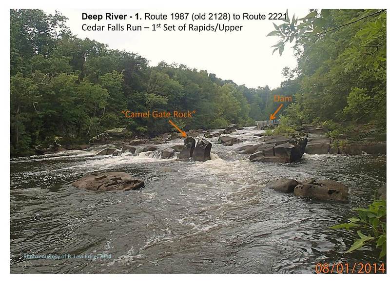
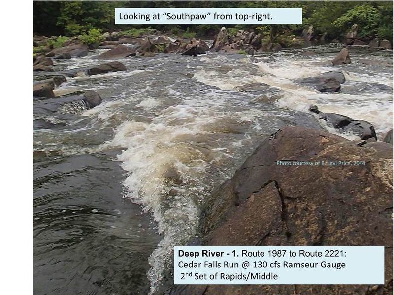
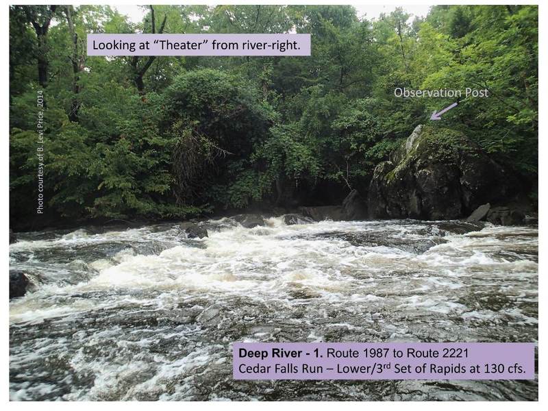
_Low-Water Run at 1.2 ft / 130cfs:_ There's only so much you can say other than simply follow the main flow. If you pay attention, you can keep yourself from getting barricaded by shallow rocks. Once you get to the rapid I'm calling "Camel's Gate" (reference to ancient stone gates made to keep livestock out but let camels pass), there's 3 or 4 different ways to cross the ledge. In any case, you'll want to get toward river right afterwards in order to avoid a long, boney boulder garden on the north side. A secondary current flows straight down "Southpaw" but the right-to-left run is more fun. You can also drop off the right ledge, but beware of strainers and trees that can stack up on the downstream side against the bank. After one more small rapid, there's a relaxed riffle leading you across a easy ledge (playspot at higher levels), with the main flow river left. Make the next left curve and get ready to run the "Theater", with the best line on river left. This name comes from the fact that the rapid is tiered and curved like theater seating with a boulder on the northeast side serving as a balcony for observers or rescuers. Do not approach on far left, as there are several sweeping branches over the river that will dump you at almost all levels. Enter just left of the rocks and work across the rapid toward the center, curving right to avoid the "balcony boulder".and then take a break in any of the several eddies on both sides. This is a decent playspot when the level gets around 2.5 ft or more. After that, there are a few diagonal surf lines and small rapids, then you can either go home or pull over left to do it all again.
In my opinion, this section is probably Class II+/III from 400 to 700 cfs. Southpaw is fairly technical and the current gets pushy enough over 1300 cfs (3.5ft) that it probably begins to approach Class IV status. In addition, high flows create new rapids and make some of the otherwise mundane features a little sticky. -BLP 11/07/15
According to Paul Ferguson's "Paddling Eastern North Carolina", the rapids at Cedar Falls increase to Class IV as flow goes above 600 cfs (2.5 ft.).
Rapids in this Run (2)
Waterfalls (1)
Playspots (3)
Hazards & Portages (2)
Caution: The following locations may require scouting or portaging. Always check current conditions.

Difficulty
Class I-II(III)
Length
8.5 mi
Gradient
25 ft/mi
max 80
Rapids
2
2 Hazards
Access Points
Shuttle Info
See map. 30 minutes from Greensboro/High Point, 20 minutes from Julian/Liberty, 10 minutes from Asheboro. Just west of Franklinville.
Difficulty Classes
I Easy
II Novice
III Intermediate
IV Advanced
V Expert/Extreme
VI Unrunnable
Current Conditions
5-Day Forecast
Whitewater data from
American Whitewater
American Whitewater