1. Spada Reservoir to Powerhouse
Gauge Conditions
Runnable: 400.0 – 1,500.0 CFS
Data from American Whitewater & USGS
Run Map
Description
The Sultan River was one of the Pacific Northwest's premiere whitewater rivers before the construction (1965) and later enlargement (1982) of Culmback Dam. Today, paddling opportunities on the Upper Sultan only occur when the level of Spada Reservoir reaches the overflow tubes at 1450' ( view table) and water once again returns to the channel (this typically occurs only once every few years) or during extremely heavy rain events (i.e. flooding on area rivers). With the hydropower license issued in 2014, the utiliy has a goal of providing up to four whitewater boating opportunities each year with at least two of these scheduled in advance (typically in late April and early September). Check the Snohomish PUD whitewater page for more information on upcoming opportunities and to sign up in advance.
The run has a wonderful combination of complexity and difficulty without a sense of being truly dangerous. It's really the perfect advanced run; consistent, technical, and powerful. The gorge itself is absolutely beautiful: green, lush, isolated. It's a fantastic run in every sense.
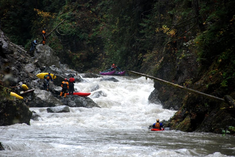
The Upper Sultan is a classic pool-drop river. There are almost no flat sections--medium-sized pools immediately lead into the next rapid. Aside from a potential wood portage, every drop is runnable and the difficulty factor is solid class IVs. Most of the run can be boat scouted and nearly every rapid is big, fun, and has a clear route.
You enter the first gorge section after passing beneath the old bridge and begin the first few miles of fun class IV boulder gardens. The action tapers off after a few miles when you squeeze through a narrow constriction in the canyon walls. This is an incredibly scenic section with some fun class III/IV rapids and some amazing waterfalls that cascade off the canyon walls.
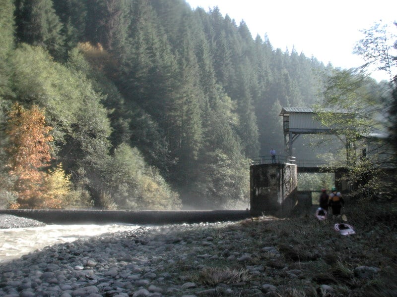
About halfway through the run (6.5 miles from the dam, 650' elevation) you reach an old diversion dam (constructed in 1930) that was used to divert water to Lake Chaplain before Culmback Dam. The diversion structure is still used and water can be piped in either direction to provide supplemental fish flows to the river or as a backup system to divert flows from the river to Lake Chaplain. The structure, which has been modified to allow fish passage, is portaged on river right. Downstream from this point the river picks up in intensity with class IV+ rapids. These are some of the best drops on the run and you'll likely have good flow coming in from side creeks that pump up the flows a bit more. It is possible to put in at the diversion dam by hiking 3.1 miles down a gated road on river right, and this reach would likely be boatable during highwater periods even when the Culmback Dam is not spilling.
Just downstream of Marsh Creek Falls which is a large waterfall on river left a massive landslide completely blocked the river in December 2004. The landslide was caught on video by a paddling group that was just below. Another group that was above this landslide was forced to hike out in the dark on river left. The landslide resulted in a fun class V rapid that could be portaged on the right. It was slightly modified to faciliate upstream fish passage and a few years later the debris forming the rapid washed downstream leaving very little evidence of this once formidable rapid. The action then tapers a bit as you reach the Horseshoe Bend section with a beautiful gorge and some great class III rapids. By the time you reach the powerhouse you've run 11 miles of great whitewater and beautiful river canyons.
If you still have daylight when you reach the Powerhouse, you can continue on the Powerhouse Run. If you have enough flow to run the Upper they will probably be running the generators at full capacity (1300 cfs) and adding this flow to the river. Last Nasty gets pretty big and sneaks up on you quickly so use caution. After that you have fun class III to the take-out.
Stephen Cameron reflects on the special qualitities of this run--'I've run hundreds of rivers all over the world in my 30 years of paddling and can say that the Sultan is probably the best and most fun whitewater run I have ever done. I'd do it in a heartbeat if I ever had the chance again.'
_with contributions from Stephen Cameron and Jennie Goldberg_
The Upper Sultan may be rated class IV, but given the length of the run, the complete inaccessibility for most of the run, and the potential for unpredictable wood hazards, this should really be viewed as a run for class V boaters or very solid class IV+ boaters already stepping it up to class V. For most of the run, hiking out is just not an option. If you swim and lose your boat or it breaks going over a drop full of water, it's going to be really bad! If you lose your paddle and don't have a breakdown, it's going to be really bad! If you get hurt and can't continue downstream, it's going to be really bad! While hiking out at the diversion dam is theoretically possible, you should not consider it an option unless there is some sort of emergency, and should instead plan on taking out at or bellow the power plant.
Continued access is dependent on showing Snohomish PUD that we are a group of responsible boaters who are not going to cause them problems. While the releases were negotiated as part of the dam relicensing and are a condition of their hydropower license, this is a cooperative arrangement between the Snohomish PUD and the boating community.
Any incidents on the Upper Sultan reflect badly on the boating community as a whole. If someone were to get hurt or lose their boat and require a rescue, it would jeopardize access to this gem for the entire boating community. This is NOT a run for stepping up to class IV! This is a run for people who already paddle class V at least occasionally. There is no hiking out of the Upper Sultan! Also, keep in mind that given the potential for wood and the tight canyon walls, it's possible that at some point in the future we might encounter a must-run rapid (cannot be portaged) with wood hazards, turning an otherwise class IV rapid into a solid class V-V+. While this is a fantastic river, and will be a pleasure for even the most hard-core class V+ boater, you should really only be attempting this run if it is half a step BELOW what you normally paddle. It would be easy to get in trouble in such a remote, inaccessible gorge, and no one wants to see anyone get hurt or killed. Please use your head, and don't attempt this run unless you have the skills and physical stamina to paddle it safely.
Logistics:
PUTIN: Just east of the town of Sultan (Highway 2 mile 23.1) turn north up Sultan Basin Road towards the Sultan Basin Recreation Area. Follow this road 13.5 miles to Olney Pass. The Culmback Dam Road heads down to the left. This road was gated for a few years but is now generally open and a public easement provides access to Forest Service property (in the past the Hydroelectric Plant Supervisor has answered questions regarding gate access and he can be reached at 425-783-8804). Just before you reach the dam an old forest road turns off to the left (FR 6122, aka the Jenny Ring Road). This road is gated but on release days the PUD will generally have the gate open so paddlers can drive in and drop off boats but park outside the gate. The traditional put-in was reached by following this road to the old log bridge a couple miles downstream from the dam (47.9701N, 121.7228W, WGS84). As a condition of the new hydropower license American Whitewater negotiated the development of a new trail into the canyon that was professionally constructed to Forest Service trail standards and completed in 2014. This trail puts you in the river one mile below Culmback Dam. Scrambling down the face of the earthen dam is tempting but considered trespassing by Snohomish PUD. Snohomish PUD has installed security cameras at the dam and informed us that they will not tolerate trespassing on the dam. The other difficulty with putting in at the base of the dam is there are reports of some class V rapids in this section that may be difficult to scout or portage. Steep canyon walls limit access between the dam and the old bridge site although there are a couple spots where river access is possible.
TAKEOUT: Most continue on the Sultan below Powerhouse run and use the Sultan fishing access at Trout Farm Road. You can reach it by taking the first street east of the Highway 2 bridge across the Sultan. After turning onto this street in the town of Sultan, take a left headed back towards the river. When you get to First Street follow it north as it parallels the river. As you pass out of town, slightly less than a mile down First Street, Trout Farm Road turns off to the left. Follow this 1.3 miles to a well marked fishing access point on the Sultan River. Park in the gravel parking area near the road and walk down a dirt road to the river. Alternative access points are available at the Powerhouse but gates will likely be locked by the time you get there, requiring you to continue downstream (they may be open on scheduled release days however).
For additional information:
- Thomas O'Keefe's Upper Sultan story and Jeff Bowman's story on Jason Rackley's Oregon Kayaking site.
- Priscilla Macy's Trip Report from 2015 at Into the Outside.
- Gary Chester's run description in: Bennett, J. and T. Bennett. 1997. A guide to the whitewater rivers of Washington, second edition. Swiftwater Publishing. Portland, OR.
Rapids in this Run (2)
Difficulty
Class IV+
Length
10.8 mi
Gradient
81 ft/mi
Rapids
2
Access Points
Difficulty Classes
I Easy
II Novice
III Intermediate
IV Advanced
V Expert/Extreme
VI Unrunnable
Current Conditions
5-Day Forecast
Whitewater data from
American Whitewater
American Whitewater