2) Allaben Portal to Phoenicia
Gauge Conditions
Runnable: 5.0 – 8.0 FT
Data from American Whitewater & USGS
Run Map
Run Time Estimate
Select put-in and take-out to estimate time.
Plan This Trip
See wind-adjusted speed maps, forecast planning, and detailed time estimates.
Sign in to generate an AI timing estimate for this run.
Whitewater timing varies with scouting, portages, and group pace. Use as a planning baseline.
Description
The Allaben portal is where water from the Schoharie Reservoir is piped into the Esopus for transport to the Ashokan Reservoir. There is almost always a minimum flow of perhaps 100CFS from the portal, and augmented flows to facilitate paddling are possible a few times a year. The usual dates are the first full weekend of June, the second weekend of July, Labor Day weekend, and the first weekend of October. Those augmented flows are dependent on approval by the NYC water supply department, and do not always happen. Confirmation of the releases will usually be posted on the website of KCCNY.
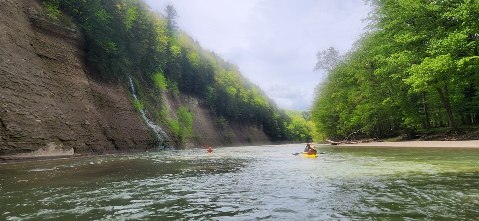
The banks of the Esopus are very prone to erosion, and there have been several deaths as a result of entrapment in strainers between the portal and Boiceville. Paddlers and tubers should expect to find strainers every time they run the Esopus. While strainers most likely on the outside of bends where the current undercuts the banks, narrower sections or channels occasionally have river-wide strainers.
About 1/2 mile down from this put-in is a left-hand turn with a very large and seemingly permanent strainer that claimed the life of a private tuber and a kayaker in the summer of 2002. They are easily avoidable but one must be aware of this danger. As a result of this strainer and the deaths the tubing companies and most paddlers put in at the fishing access next to the cemetery about 3/4 of a mile downstream of the portal. This access is labeled on Google Maps.
From the cemetery access you get right into the first playspot called "Cartwheel Hole" which is a double squirt line separated by a large boulder in the center of the river. Mystery moves have been gotten here by squirt boaters between 5.5 and 6 ft. This is also a great place to practice ferries, peel outs and eddy turns to get warmed up before continuing.
From here it's more of a technical class II with some surf-on-the-fly waves and squirt lines, always different depending on levels.
Immediately upstream of the creek at Woodland Valley is the class III "Tenderizer" hole (rarely playable but fun to try), the railroad wave (class II surf), and then Railroad Rapid (still listed as an AW benchmark class III, but now only class II at typical flows) which is the site of long-standing slalom races. Many boaters get out here, about 3 miles down from the portal. The next significant rapids occur as you enter Phoenicia.
After the Phoenicia bridge, the third bridge from the put-in, is Elmer's Bend, a class III rapid with many different characteristics depending in the level. The most common route starts by going right of the prominent boulder in the center, and then left to right thru the rock garden, while continuing straight thru river right and over a little drop is another option, especially at higher levels. Elmer's also offers plenty of eddy hopping for those wanting some practice. There's also a challenging surf at the very bottom.
There are several take-out options below Elmer's. The most common is a fishing access about 1 mile downstream on river left. It's also possible to continue another mile to the river right access at the parking area on Route 28 or to continue another 5 miles to the river left take out behind the Boiceville IGA. See the AW description for that section for more information.
Catskills Area Reaches
Basic CreekBatavia Kill Bear Kill
Beaver Kill (Delaware Trib)Beaver Kill (Hudson Trib) Beer Kill
Beer Kill, W. BranchBowery Creek Bush Kill
Callicoon Creek, E. BranchCallicoon Creek, N. Branch Catskill Creek (1.)
Catskill Creek (2.)Catskill Creek (4.) Claverack Creek
Coxing KillDelaware Delaware, E. Branch
Delaware, W. BranchLittle Delaware Dry Brook
East KillEsopus Creek (1) Esopus Creek (2)
Esopus Creek (3)Esopus Creek (4) Esopus Creek (5)
Hannacrois CreekKaaterskill Creek (1.) Kaaterskill Creek (2.)
Kinderhook Creek (3.)Kiskatom Creek Mombaccus Creek
Mill BrookNeversink (1.) Neversink, E. Branch
Neversink, W. BranchPeters Kill Platte Kill
Plattekill CreekPotic Creek Roeliff Jansen Kill (1)
Roeliff Jansen Kill (2)Rochester Creek Rondout Creek (1)
Rondout Creek (2)Rondout Creek (3) Sandburg Creek
Saw Kill (1)Saw Kill (2) Saw Kill (3)
Schoharie Creek (1.)Schoharie Creek (2.) Shingle Kill Creek
Squirmer CreekStony Clove Creek Ten Mile Creek
Thorp CreekTremper Kill Wallkill
West KillWoodland Creek Vly Creek
Google Map of New York Whitewater
New York Whitewater Paddlers Facebook Group
Rapids in this Run (2)
Hazards & Portages (1)
Caution: The following locations may require scouting or portaging. Always check current conditions.
Difficulty
Class II-III
Length
4.6 mi
Rapids
2
1 Hazard
Access Points
Difficulty Classes
I Easy
II Novice
III Intermediate
IV Advanced
V Expert/Extreme
VI Unrunnable
Current Conditions
5-Day Forecast
Whitewater data from
American Whitewater
American Whitewater