2. Brewster Bridge to Burnt Mill Bridge
Gauge Conditions
Runnable: 300.0 – 4,000.0 CFS
Reasonable low-water run.
Data from American Whitewater & USGS
Run Map
Description
This run starts off with under Brewster's Bridge. There's ample parking at the put in and good river access.
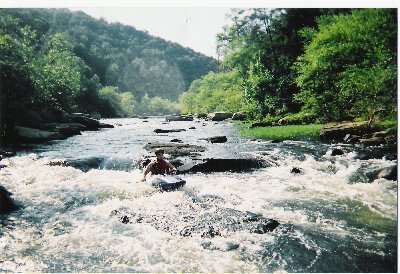
The first few miles are pretty calm. You will travel through a narrow sandstone gorge before the action picks up. At mile 4 the first rapid of significance will appear. Look for a large over hanging rock on river right. This is Decapition Rock. At lower flows the river forces you to go under the overhang, but at flows above 1500cfs the river is to high to pass under the overhang. This forces you to boof over the big rock in the middle of the river. Scouting is best on river right. If you have to boof this drop, be aware that the hole at the bottom will be very sticky. At levels over 1500cfs I would classify this as a III.
There are a few more small rapids before the confluence with Whiteoak Creek, which comes in on the right. (There is some beautiful scenery up Whiteoak Gorge, making it a fine run, if you don't mind the flatwater paddle-in). Not far down stream there will be a long flatwater section and a sandy beach area on the right with a rope swing. You are now less than 3 miles from the take out. After the beach there are some faster sections of water.
The next rapid of significance is Swimmers Rapid about 0.7 miles downstream. This is a small ledge that has a large "flipping rock" in the middle. Best run from right to left to avoid the rock. At higher levels this becomes a riverwide hole. There is a large recovery pool at the bottom.
About 1 mile past Swimmers, there are two campsites on river left. If you look closely you will see trails leading to the river from the campsites. After the campsites there are a few short rock gardens before the long flatwater paddle to the take out. Beware at lower levels as the flatwater section can be dangerous on river right. There have been numerous drownings on these sections. This is not a problem if you stay in your boat and don't get out to swim.
The take-out is on the left before the bridge.
Playspots (1)
Hazards & Portages (1)
Caution: The following locations may require scouting or portaging. Always check current conditions.
Difficulty
Class II+
Length
10.5 mi
Gradient
14 ft/mi
max 40
Rapids
0
1 Hazard
Access Points
Difficulty Classes
I Easy
II Novice
III Intermediate
IV Advanced
V Expert/Extreme
VI Unrunnable
Current Conditions
5-Day Forecast
Whitewater data from
American Whitewater
American Whitewater