2. Chatham Church Rd to Deep River confluence
Gauge Conditions
Runnable: 200.0 – 1,200.0 CFS
Upper limit now at 1200, based on 11/03/15 run.
Data from American Whitewater & USGS
Run Map
Interactive run map
Loads as you approach this section.
Run Time Estimate
Select put-in and take-out to estimate time.
Plan This Trip
See wind-adjusted speed maps, forecast planning, and detailed time estimates.
Sign in to generate an AI timing estimate for this run.
Whitewater timing varies with scouting, portages, and group pace. Use as a planning baseline.
Description
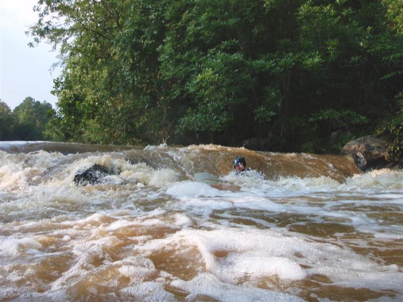
This is a nice run to try when the Lower Haw is at flood. It is a bit harder than the Middle Haw and a bit easier than the Lower Haw. At good flow levels there is one class III ledge and bunch of class I to II+ rapids along this stretch. There are lots of small play features - bring the playboat if you have one.
Before starting, check out the run from the 15/501 bridge over the Rocky River. This bridge is about 7 miles south of Pittsboro. After crossing the bridge, turn into the drive on the left and park on the old road right of way that parallels 15/501. You can then use the bridge to take a look at the river. If you see a lot of rocks downstream from the bridge, it is probably too low. The class III ledge can be seen upstream from the 15/501 bridge in the distance. There is also a visual gauge on the river right downstream bridge support. There is a goat trail down to the river you can use to look at the visual gauge. A good minimum is probably -6 inches. The run is fun at 6 inches to 1 foot. At 2 feet, bank sweepers are common and the river washes into the trees in numerous places. There are lots of great play features at around 2.5 feet. Many of the small features probably start to wash out above 3 feet.
The put-in is where Chatham Church Road crosses the Rocky River. This is a one-lane dirt road with a steel trestle bridge, with decent pullouts on both sides. Access trail is river-left. The takeout is just before the Rocky River confluences with the Deep River, in TLC's White Pine Preserve. You have to hike about 10 minutes up a well-maintained trail to the parking lot.
From the put-in there is about 2/3 a mile of flatwater for a nice warm-up. You will see a small deck/dock on the left and then the river bends to the right. Just after the bend, class I rapids begin. It starts with some pretty mild ledges. There are some small waves to surf just to warm up a bit. After a few ledges, there is a larger rapid. This rapid is a 4-5 foot ledge. On river right it is a broken ledge of 2 or 3 drops depending on the spot chosen. On the river left it is a single drop with a fairly sticky hole at the bottom. At higher flows, this one can rip the paddle out of your hands and thrash you a bit. In the middle there are a couple of nice slots with a two stage drop that are fun. Pick your line - a nice recovery pool awaits below to pick up the pieces if needed.
Once you eddy out below the rapid, you can spend some time playing a small wave near the middle of the river. After you finish playing, a couple more rapids await before crossing below the 15/501 bridge. After crossing under 15/501, there are a few straight-forward rapids. The river bends to the left and the class I-II rapids continue. There are a few playspots but nothing too interesting. The second stretch of flat water begins near where the river makes a bend to the right. At about mile 2.5 in this section, there is a larger creek entering on river left (look for a duck blind) across the river from a private picnic area. Look closely and you'll see a 3-4' waterfall 100 yards upstream. A nice place to paddle into to appreciate the moment.
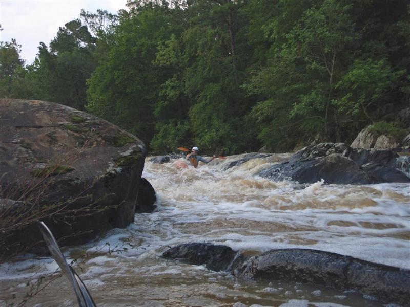
After about 1/2 mile of flatwater, the river bends around to the right and the rapids start again. From this point, the gradient picks up a bit and the rapids are pretty constant to the takeout. The right side of the river begins to drop through a small gorge. It is very pretty in the spring when the mountain laurel and rhododendron are in bloom.
In this last section there are several nice class II+ ledges and rock gardens. There are a bunch of places to surf and play your way down the river. Somewhere around mile 3.1, a small island splits the river for a short distance and there is one ledge that begins to form a hole above 1.5 feet. After a bit over a mile of fun, the last rapid is a wavetrain. Pay attention and you'll notice a small power line passing over head, white pines growing on the bluffs, then one more small rapid. After this rapid, when the river is running you normally hit the backwater from the Deep River. Once in the flat water, move to river right and look for a small creek (after TLC's property corner) along with trail markers. You can take out here and follow the trail up to the parking lot.
Difficulty
Class II+(III)
Length
4.0 mi
Gradient
18 ft/mi
max 40
Rapids
0
Access Points
Shuttle Info
From the 15/501 bridge over the Rocky River, you reach the takeout by going south on 15/501 to the next 4 way intersection. Turn left onto River Fork Road. You then make an immediate left which is still River Fork Road. You follow this a bit less than a mile and turn right which is still River Fork Road (going straight is a dead end). You follow this for a little less than a mile and bear to the left when another road comes in from the right. The road turns to gravel at this point. You continue on until you see signs for the White Pines Preserve. You park in the lot at the White Pines Preserve (managed by Triangle Land Conservancy). From the lot it is a 10 minute hike down the hill to the river. You follow the trail just to the left of the map board in the parking lot. This trail goes down the hill, past the power line right of way, then down past a gate. A bit after the gate the trail forks - take the left fork down to the river. You might want to check it out when setting shuttle so you know what to look for when taking out.
From the takeout parking lot, retrace back to where River Fork Road crosses 15/501. Go straight across 15/501 and the road changes name to Walter Bright Road. You follow Walter Bright Road about half a mile and turn right onto Wade Bright Road. You follow Wade Bright Road for about half a mile until it ends at a "T" intersection. Turn right onto Asbury Church Road. You follow Asbury Church Road for about half a mile and then the name changes to Chatham Church Road. Follow this road after it turns to gravel and it will cross the Rocky River. After crossing the river, make a sharp right onto a gravel drive and park under the bridge.
The shuttle directions sound complicated but they aren't really that bad.
Difficulty Classes
I Easy
II Novice
III Intermediate
IV Advanced
V Expert/Extreme
VI Unrunnable
Current Conditions
5-Day Forecast
Whitewater data from
American Whitewater
American Whitewater