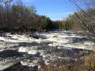
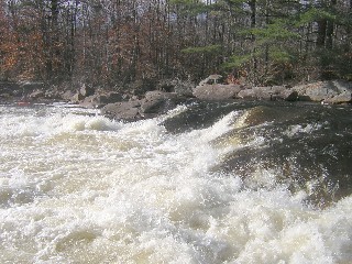
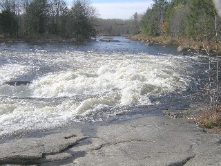
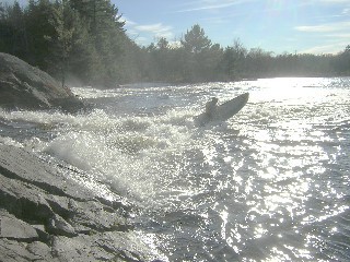
2. Lower: Rock Island to Fowlersville
Gauge Conditions
Runnable: 3.8 – 10.0 FT
It gets quite bony much below 4 ft, but the rapids can still be real at the lower levels.
Data from American Whitewater & USGS
Run Map
Interactive run map
Loads as you approach this section.
Description
## Video Guide Click Here
Logistics:
See the Lower Moose Map. The normal putin is at Rock Island, off Moose River Road, about three miles West of Rte. 28. The takeout is at Fowlerville Road, the normal putin for the Bottom Moose. To get to the takeout from the putin, continue West on Moose River Road for about 4 miles.
Bear Right at Porter's Corners, staying on Moose River Road.
After another 2.5 miles, take a Right onto North South Road.
At the T intersection, hang Left onto Penny Settlement Road.
After a short drive, take your first Right onto Fowlerville Road. The river's about a mile and a half along Fowlerville. Park before the river, on the left or the right. (There's a good sandy parking area on the left.)
See also the Google Directions from Utica.
Those wishing to run the class-4 section usually put in at Rock Island. Those wishing to run the class-3 section (Middle Moose) usually take out at Rock Island: Longitude - 75, 09, 27 and Latitude 43, 36, 01.
See also the Middle Moose, Class III, and Bottom Moose, Class V.
Tug Hill - Old Forge Area Reaches
Beaver (1. Moshier)Beaver (2. Eagle) Beaver (3. Taylorville)
Black (1.) Black (2.) Black (3.)
Black (4.) Black (5.) Black, S. Branch
Cincinnati Creek Crystal Creek Deer River (Section 1)
Deer River (Section 2) Fish Creek, E. Branch Independence River (1. Upper)
Independence River (2. Main) Indian (S.Br. Moose trib.) Little Black Creek
Little Woodhull CreekMad River Mill Creek
Mohawk (1.) Moose (1. Middle) Moose (2. Lower)
Moose (3. Bottom)Moose, Middle Branch Moose, S. Branch (1.)
Moose, S. Branch (2.) Negro Brook Otter Creek
Roaring Brook (Brokeback Gorge) West Canada Creek (1.) West Canada Creek (2. Ohio Gorge)
West Canada Creek, S. BranchWoodhull Creek (Upper) Woodhull Creek (Middle)
Woodhull Creek (Miracle Mile)
Google Map of New York Whitewater
New York Whitewater Paddlers Facebook Group
Difficulty
Class III-IV
Length
8.1 mi
Rapids
6
Access Points
Shuttle Info
**Logistics:**
The map shown below may not be correct; I'm not at all certain that you can cross the river on the bridge that they recommend you use.
See the [Lower Moose Map](http://www.americanwhitewater.org/photos/?photoid=13873). The normal putin is at Rock Island, off Moose River Road, about three miles West of Rte. 28. The takeout is at Fowlerville Road, the normal putin for the Bottom Moose. To get to the takeout from the putin, continue West on Moose River Road for about 4 miles.
Bear Right at Porter's Corners, staying on Moose River Road.
After another 2.5 miles, take a Right onto North South Road.
At the T intersection, hang Left onto Penny Settlement Road.
After a short drive, take your first Right onto Fowlerville Road. The river's about a mile and a half along Fowlerville. Park before the river, on the left or the right. (There's a good sandy parking area on the left.)
See also the [Google Directions from Utica](http://maps.google.com/maps?f=q&hl=en&q=Utica,+NY+to+43.6086006N,+75.161499W&ie=UTF8&z=9&ll=43.355141,-75.171204&spn=0.858741,1.966553&om=1) and see the [Google Directions from the takeout to the putin](http://maps.google.com/maps?f=d&hl=en&geocode=14003560346497251340,43.621113,-75.274597%3B497224474998262109,43.608601,-75.161499&saddr=43.6211128N,+75.2745972W&daddr=43.607245,-75.289135+to:43.6086006N,+75.161499W&mra=dpe&mrcr=0&mrsp=1&sz=13&via=1&sll=43.600657,-75.245018&sspn=0.055443,0.122395&ie=UTF8&z=13).
_Latitute/Longitude coordinates verified by GPS._
Difficulty Classes
I Easy
II Novice
III Intermediate
IV Advanced
V Expert/Extreme
VI Unrunnable
Current Conditions
5-Day Forecast
Whitewater data from
American Whitewater
American Whitewater