2 - Pilchuck Creek Campsite to Highway 9 Bridge
Gauge Conditions
Runnable: ? – ? CFS
Approximate reading: This gauge is 6.0 miles away on Pilchuck Creek. Use as a general reference only.
Data from American Whitewater & USGS
Run Map
Run Time Estimate
Select put-in and take-out to estimate time.
Plan This Trip
See wind-adjusted speed maps, forecast planning, and detailed time estimates.
Sign in to generate an AI timing estimate for this run.
Whitewater timing varies with scouting, portages, and group pace. Use as a planning baseline.
Description
Pilchuck Creek has a beautiful low-elevation gorge and a fun 16' waterfall. The flashy nature of this creek that runs on winter rains makes it a hard one to catch. It can be at a perfect level on a Thursday, but way too low by the weekend. It used to be more challenging to figure out when the creek was running until Washington DOE added a real-time gage. Those who time it right are rewarded with a journey through a very rare low-elevation river system with no development in the river corridor. Logging occurs in the upland forests and it has been a popular dumping ground for old cars (resulting in closure of the road to the put-in), but the lush green gorges remind one of some of the runs on the Olympic Peninsula. It's a wonderful place in the middle of an otherwise grey Pacific Northwest winter. Although this run is mostly continuous class III+ at moderate flows, there are a couple of drops that push class IV, and the whole run can become class IV at higher water levels. Although a road runs along river right, access to the canyon is relatively limited.
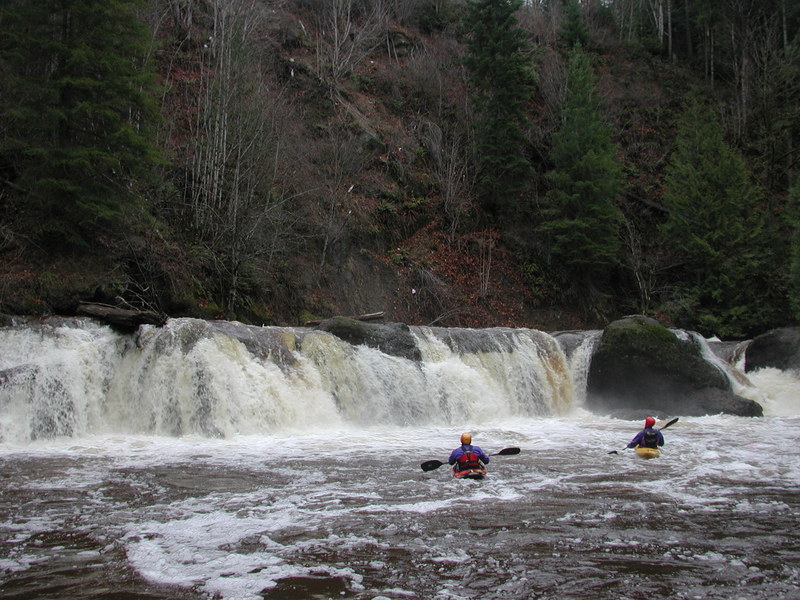
The run starts out with class III which builds to III+ as you enter the first bedrock canyon. It's a short paddle to Pilchuck Falls. You'll recognize it from powerlines overhead. The river takes a hard bend to the left and crashes through the most significant rapid on this section as the powerlines come into view. A large pool forms at the end of the last rapid above the falls so get over to river right to scout or potentially portage the falls.
Scouting Pilchuck Falls will quickly reveal that you want to avoid the nasty hydraulics on river left (where most of the flow heads). There are routes on river right or towards the center. If you have never run the falls it's best to go with someone who has and knows the lines. They aren't too difficult to figure out, but a rock to the left of the center line is submerged at higher flows. The drop is often rated class V, but the launch from the pool at the top is fairly straightforward and the bottom has a good recovery section. At high flows, the powerful hydraulics that develop convince many to portage. Whit Deschner's has a story of his first descent of the falls in his book, When the Wet Suits You. If you elect to portage the falls, then you have to scramble up the bank on river right. A rope is useful.
Downstream from the falls, the river bounces through two awesome canyon sections with nearly continuous rapids. These are generally III+ at moderate flows, but build to a class IV flush at higher flows. Some fun play spots can be found throughout the run and you are rewarded with views of lush ferns and mosses which carpet the gorges formed of bedrock and loose gravel deposits. Use caution as you approach some of the narrower sections. There are a couple points where river-wide strainers have blocked the river in some years.
As you leave the second gorge the river opens up and you are at the take-out bridge. Take a peak at the staff gauge as you pass on river right about 50 yds. upstream from the bridge.
Those looking for a longer 10 mile run can also add Pilchuck Creek's Upper Section.
Access Logistics:
Paddlers meet at the Highway 9 Bridge just north of Arlington at Highway 9 mile 34.9. Parking and a trail to the river are found on the downstream river right side of the bridge. From the bridge, drive 0.3 miles north on Highway 9 and turn right onto Finn Settlement Rd. (labeled as 44th Ave NE in the Gazetteer). Drive 4.5 miles along this road and turn right at the Y. Take the right fork to reach the river but you'll have to start hiking as WA DNR gated the road in 2003.This road parrallels the river and you can get a look at Pilchuck Falls 0.3 miles from the Y. You'll see a spot to pull off the road and a trail that takes you down to where you can check out the falls (and the end of the rapid just upstream). For those who know they don't want to run the falls, scrambling down the bank and putting in here is an option. Otherwise continue up the road to a logging bridge 0.9 miles from the Y. You can put-in at the campsite on the upstream river left side of the bridge.
Waterfalls (1)
Difficulty
Class III-IV(V)
Length
5.8 mi
Gradient
57 ft/mi
Rapids
0
Access Points
Difficulty Classes
I Easy
II Novice
III Intermediate
IV Advanced
V Expert/Extreme
VI Unrunnable
Current Conditions
5-Day Forecast
Whitewater data from
American Whitewater
American Whitewater