2 - Town Creek Church Bridge (a/k/a Garnett Bridge) to Copper Mine
Gauge Conditions
Runnable: 600.0 – 20,000.0 CFS
Data from American Whitewater & USGS
Run Map
Description
Sources: S. Welander, B. Sehlinger and D. Otey, A Canoeing & Kayaking Guide to Georgia (2004); B. Sehlinger and D. Otey, Northern Georgia Canoeing (1980).
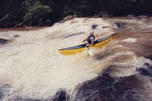
This is the most exciting section of the Chestatee, including Class II-II+ rapids at the put-in and in the first 2+ miles, Class 5.0 Grindle Falls (a/k/a Grindle Shoals)and Class III+ Copper Mine at the take-out. The two miles from shortly below Grindle Falls to shortly above Copper Mine are flatwater.
The put-in at Town Creek Church Bridge (a/k/a Garnett Bridge) includes a parking area sufficient for several cars. The easest way down the steep hill to the river is via the path on the upstream side of the bridge, right at the parking area.
There is an alternative put-in/take-out at Grindle Bridge, 1.8 miles below the put-in. Parking is scarce, however, the land surrounding the bridge is privately owned and the owners are not big fans of boaters. Please use Grindle Bridge as a drop-and-drive put-in/take-out and do not leave vehicles parked there during your run.
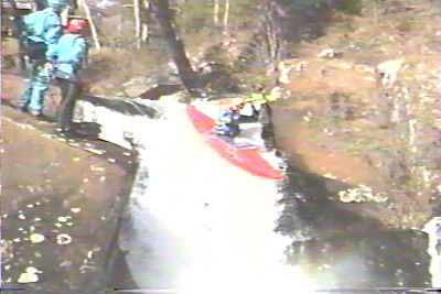
Grindle Falls (a/k/a Grindle Shoals) is a fun series of vertical drops and slides. The falls can be run by going either right or left of the island above them (see comments below): scouting is necessary to make sure the chosen route isn't blocked by trees. In the past there have been access problems with the landowner on the river right bank. Its best to be quick and discreet when scouting from either bank or portaging.
Portaging Grindle Falls is difficult: neither bank is easy, but the left is less difficult. The property on both sides is private, so do not linger. There is no good portgage option other than the banks: the least bad road portgage would be take the road east about a mile to where Tesnatee Creek nearly meets the road, then take Tesnatee Creek back to the Chestatee shortly below Grindle Falls.
Fun factoid: Sehlinger and Otey (1980) considered Grindle Falls to be a mandatory portage. To quote an unidentified contributor to this page, "we have come a long way since then."
NOTE: the property at the confluence of Testnatee Creek and the Chestatee (river right on Testnatee Creek, river left on the Chestatee) is currently on the market. If you know any potential paddling-friendly buyer for that property, please email the streamkeeper at chestateer@yahoo.com.
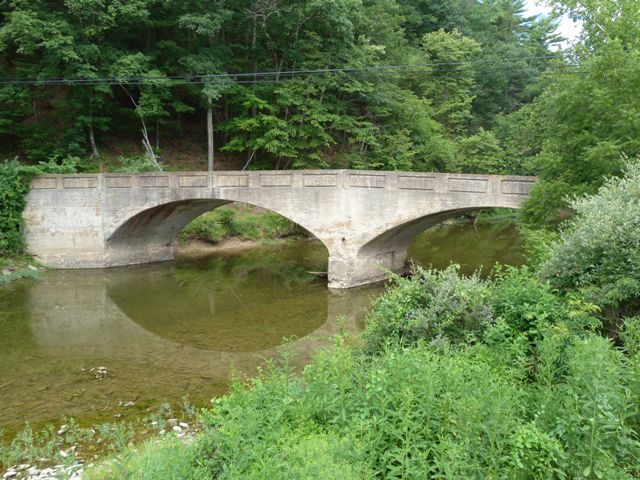
The takeout is just below the concrete bridge two miles below Grindle Falls. Just above the bridge is a small dam, the remnant of a collapsed larger dam that provided electricity for the now-closed copper mine. There are several lines through the dam, the largest and cleanest of which is to the left of center.
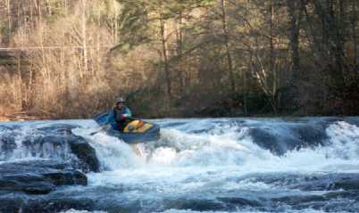
Class III+ Copper Mine, about 100 yards below the bridge, should be scouted. If you prefer to take out before Copper Mine, stay to the right of the small island on river left just below the bridge, then turn left just below the island and take out at the wash. You can follow the path back upstream to the bridge (don't go up the road to the right - its fenced at the top) or downstream to put back in below Copper Mine.
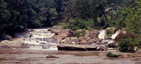
Copper Mine consists of three ledges, of which the first is the most challenging. The usual run is angling left, just to the left of the boulder slightly right of center, but other routes are possible. The usual route for the two lower ledges is on river right.
The take-out is shortly below Copper Mine, around the small point on river left. Take the path back to the bridge (don't go up the road to the right - its fenced at the top) or above the rapid to run it again.
An interesting feature at the take-out is the old copper mine the rapid is named for. The mine entrance is on river left near the end of the rapid. In the 1970's, a concert was held in the large chamber reached via that entrance. Another artifiact of the copper mining era is the steel remnant of the bridge that used to carry the road over the Chestatee and provided access to the mine.
Though rarely or never patrolled, the entire left bank is private property. Please do not litter, damage the property in any way or linger overlong.
DIRECTIONS:
Take Highway 400 to where it ends at Highway 60 in Lumpkin County. Continue straight on the two-lane road, through the stoplight at the Highway 52 intersection. The take-out is at the bridge about .8 mile beyond that intersection. The dirt road down to the river left bank is now blocked by a fence, so parking is roadside only. The path to/from the take-outs above and below Copper Mine rapid begins under the south (river left) end of the bridge.
To reach the put-in, continue north until the road ends at Cavender Creek Road. (From that intersection, the alternative put-in/take-out at Grindle Bridge is about 1.3 mile to the right on Cavender Creek Road.) Turn left on Cavender Creek Road, go about one mile and turn right on Town Creek Church Road. You'll recross the Chestatee in about 2 miles: parking for the put-in is on the left just beyond the bridge.
Rapids in this Run (1)
Waterfalls (1)
Playspots (3)
Hazards & Portages (4)
Caution: The following locations may require scouting or portaging. Always check current conditions.
Difficulty
Class II-V
Length
3.8 mi
Gradient
50 ft/mi
Rapids
1
4 Hazards
Access Points
Difficulty Classes
I Easy
II Novice
III Intermediate
IV Advanced
V Expert/Extreme
VI Unrunnable
Current Conditions
5-Day Forecast
Whitewater data from
American Whitewater
American Whitewater