3. Antioch Bridge to Devils Breakfast Table Bridge Wild
Gauge Conditions
Runnable: 300.0 – 2,000.0 CFS
Data from American Whitewater & USGS
Run Map
Put-in
Take-out
Rapids/Hazards
Wild
Run Time Estimate
Select put-in and take-out to estimate time.
Plan This Trip
See wind-adjusted speed maps, forecast planning, and detailed time estimates.
Sign in to generate an AI timing estimate for this run.
Whitewater timing varies with scouting, portages, and group pace. Use as a planning baseline.
Description
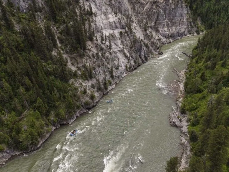
What a terrific run! The first couple of miles has a lot of flat water with several Class II to Class III- rapids to get warmed up. The confluence with Yellow Creek on river right is the sign that the difficulty will soon pick up. Within a quarter mile you will see the clifts of the 'canyon' section with super whitewater in the form of ledges and play holes. The big one here is 'Rattlesnake' (Class IV+) which as you might guess is a double curved rapid with a ledge at the end. By the way, the rattle is at the front and the 'fang' is the last ledge drop of the rapid which is ususally run center to right center.
Rob Martin contributed:
The scenery is spectacular! The water is emerald green. The whitewater is challenging without being extreme. Just mentioning Daddy's Creek Canyon will bring a smile on anyone's face who has experienced this place.
Caution!! Access to Devil's Breakfast Table is controlled by the Tennessee Wildlife Resources Agency. Catoosa WMA is closed for Feb 1 thru March 27, 2015 for a wildlife rest period and access to the WMA is closed to all users and no vehicle access is allowed. December 4-7, 2015 is closed for a deer hunt. April 10-12, 14-16, 18-19 (Young Sportsman Hunt), 21-23, 24-26, 28-30 and May 1-3, 2015 are turkey hunts. During these hunting days, the Catoosa WMA access is restricted to all but hunters. There are _usually_ signs posted during hunts and rest periods alerting you that the area and roads are closed to access. If you are uncertain, check at the NPS Obed Wild and Scenic River office in Wartburg or with TWRA. TWRA has fined boaters in the past for driving to and parking at the Devil's Breakfast Table parking area during these hunts and restricted times. The fine has been as much as $142 per person.
TWRA Contact: Jim Lane (931) 456-2479.
An alternate access point below Devil's Breakfast Table is located about 2 miles downstream on river left after the confluence with the Obed River, known as Obed Junction (OBJ). The carry-out is up a 3/4 mile steep, rocky trail. The shuttle from Antioch Bridge to OBJ is 43 miles in each direction. OBJ is very isolated with little traffic and has been the site of vandalism in the past. Don't leave valuable items in your vehicles.
Rapids in this Run (1)
Difficulty
Class III-IV
Length
6.8 mi
Gradient
37 ft/mi
max 100
Rapids
1
Access Points
Difficulty Classes
I Easy
II Novice
III Intermediate
IV Advanced
V Expert/Extreme
VI Unrunnable
Current Conditions
5-Day Forecast
Whitewater data from
American Whitewater
American Whitewater