3. Burnt Mill Bridge to Confluence with New River
Gauge Conditions
Runnable: 250.0 – 2,500.0 CFS
Data from American Whitewater & USGS
Run Map
Description
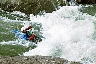
Clear Fork consists of mostly class II+ rapids with one class III near the end. It is frequented by boaters looking to make the Big South Fork of the Cumberland run longer.
Burnt Mill Bridge to Confluence Shuttle Information
From the takeout parking lot take John Long Road for 4.8 miles. Make a right on Airport Road for 1 mile. Turn left on Detour Road for 1 mile. Turn right across the railroad tracks. Make a right on Hwy 27. Go 6.0 miles to Old Hwy 27, which is the second right past the New River Bridge. Follow Old Hwy 27 for 1.3 miles to B&H Market and Deli. Make a right then a left at the next stop sign. Go about 2 miles to the Crossroads Church and make another right. Burnt Mill Bridge will be approximately 1 mile.
Here is a link to a Big South Fork area map. The roads mentioned above are very detailed on this map.
Camping Options
Camping options are available in the Big South Fork National River and Recreation Area.
Additional Information
For additional information about paddling in the Big South Fork National River and Recreation Area, checkout A Guide to Paddling in the Big South Fork.
Here is a link for all information on the Big South Fork National River and Recreation Area.
Contact the streamKeeper: Brandon Hughett, Knoxville, Tennessee
Rapids in this Run (1)
Difficulty
Class II+(III)
Length
3.9 mi
Gradient
20 ft/mi
Rapids
1
Access Points
Difficulty Classes
I Easy
II Novice
III Intermediate
IV Advanced
V Expert/Extreme
VI Unrunnable
Current Conditions
5-Day Forecast
Whitewater data from
American Whitewater
American Whitewater