3 - High Shoals to Price Mill
Gauge Conditions
Runnable: 100.0 – 8,000.0 CFS
Upper limit for best boatability uncertain. Please help your fellow boaters with a comment or report.
Data from American Whitewater & USGS
Run Map
Run Time Estimate
Select put-in and take-out to estimate time.
Plan This Trip
See wind-adjusted speed maps, forecast planning, and detailed time estimates.
Sign in to generate an AI timing estimate for this run.
Whitewater timing varies with scouting, portages, and group pace. Use as a planning baseline.
Description
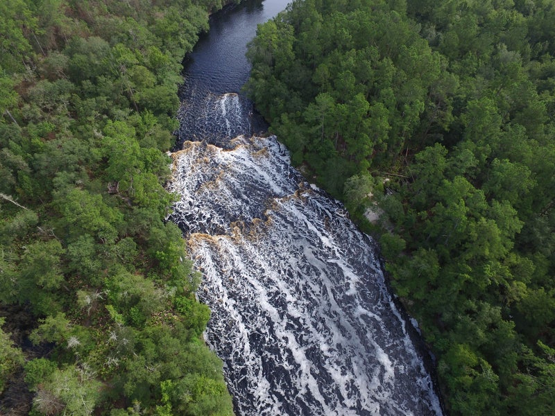
Directly below the Hwy 186 bridge, there is a 6 foot high dam followed by a series of small drops that lead to a large sliding drop of about 25-30' that ends in a big pool. The dam is best run far left. See WARNING below. The sliding drop can reportedly be run on most sides although the launch pad in the center is preferable for nice boofs at higher water.
Minimum level should be considered around 350 cfs, but at this level it will be mighty scrapy. Better flows are from 500 or so and more. Around 2000-3000 cfs, boofs off the launch pad get really fun and lofty.
Below High Shoals the river is class I-II until Price Mill Shoals which is just upstream of the Hwy 186 Bridge. Price Mill is a straight-forward rapid but does have several large hydraulics to punch.
WARNING: As of 2021 the landowners on both sides of the river, below Hwy 186, flanking High Shoals, do not want trespassers on their land. It is suggested that you scout the dam from under the bridge on river left. Run the dam far river left and make your way to the center island. You may be able to get out on the island and scout the final slide. If not study the image of the shoals below (to be posted soon). The blue line takes you right of the island, then cuts back left to hit a boof that skips you over the bottom hydraulic. The green line goes right of the island and is the direct, more steep route. Still good. WARNING: Do not get out on the beach on river left, this landowner is purportedly very aggressive to trespassers and may be armed. If you encounter this landowner, do not engage.
There is no known place to park and put on at Hwy 186. The best option is to park at the Post Office and find someone who is local and ask permission. Otherwise put in at Snows Mill Road upstream. To bypass High Shoals altogether, it may be possible to put in on Robinson Creek at Gober Rd and float/scrape 400 feet to the main river.
Rapids in this Run (1)
Difficulty
Class II-III(IV)
Length
5.0 mi
Rapids
1
Access Points
Difficulty Classes
I Easy
II Novice
III Intermediate
IV Advanced
V Expert/Extreme
VI Unrunnable
Current Conditions
5-Day Forecast
Whitewater data from
American Whitewater
American Whitewater