3. Horseshoe Bend (Redinger Dam to Kerckhoff Reservoir)
Gauge Conditions
Runnable: ? – ? CFS
Approximate reading: This gauge is 0.1 miles away on San Joaquin. Use as a general reference only.
Data from American Whitewater & USGS
CDEC Flow Data California
Data from California Data Exchange Center (CDEC)
Run Map
Run Time Estimate
Select put-in and take-out to estimate time.
Plan This Trip
See wind-adjusted speed maps, forecast planning, and detailed time estimates.
Sign in to generate an AI timing estimate for this run.
Whitewater timing varies with scouting, portages, and group pace. Use as a planning baseline.
Description
Horseshoe Bend is a beautiful section of river that has seen relatively little boating use in the past. It only has boatable flows during periods of spill; typically late Winter and Spring of an average to high water year. Many years there is no spill at all and therefore no boatable flows. Scheduled weekend recreation releases will happen in the future if certain fishery studies allow it. In the meantime SCE started providing real time flow information in the summer of 2006, which will allow boaters to use this reach whenever there is boatable flow.
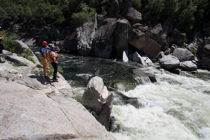
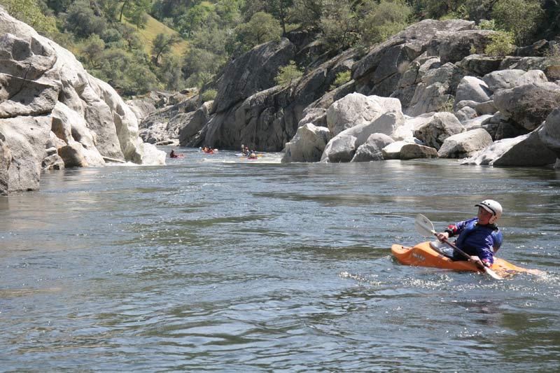
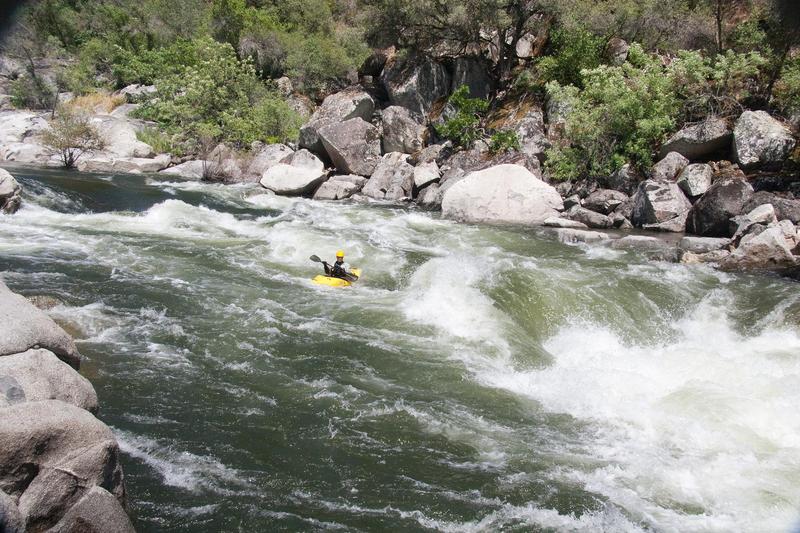
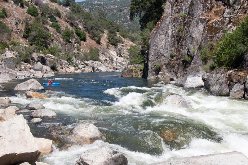
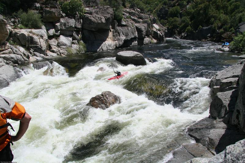
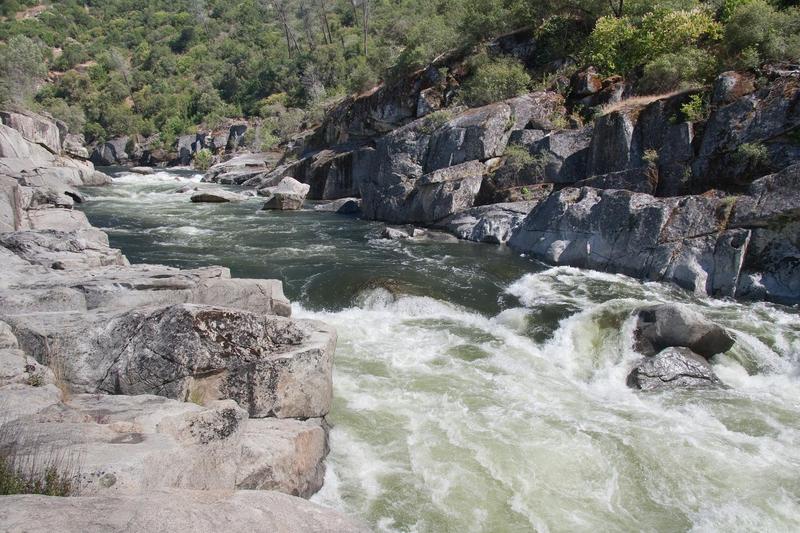
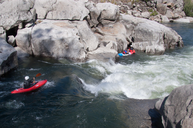
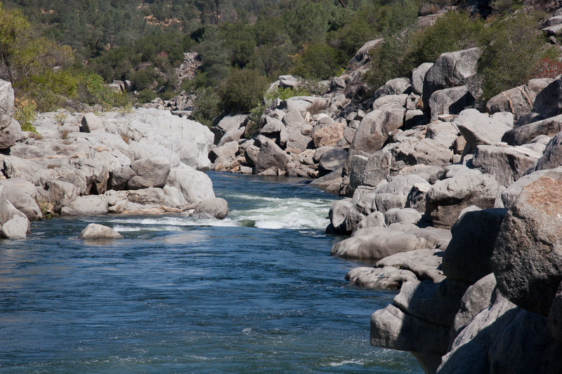
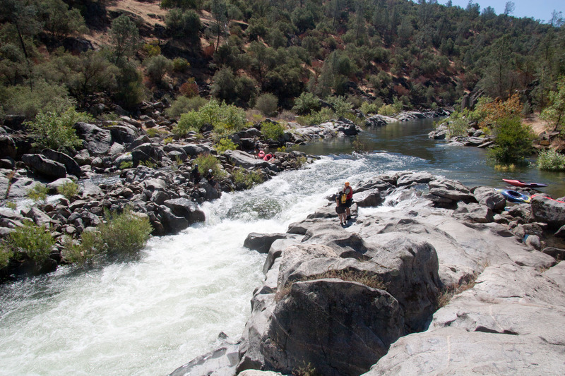
The river character is classic pool drop, with long pools separating relatively short steep drops. The streambed is a deep granite trench and many rapids are formed by large boulders. Most rapids, even the small ones, have distinct horizon lines, which hide any view of the correct route until you are just about entering the rapid or have in fact committed to the rapid. Low cliffs or sculpted boulders form much of the shoreline, but all rapids are easily scouted from shore. There are a few small beaches along the length and one large beach at about the halfway point. It is a very pretty section of river.
Time required: One can enjoyably spend all day, but fast trips are also feasible. A recent kayak trip at 2000 cfs with 3 boaters, doing 4 scouts, two portages, 1 swim, and numerous rolls, took 2 hours and 15 minutes from put-in to take-out.
The Horseshoe Bend Trail is on river right. It comes close to the river in a couple spots, but usually it is several hundred yards up on the hillside. Sometimes its path is obvious but in many other areas it is faint. The downstream end of this trail starts where the road to the powerhouse is gated. The upstream end starts from a level area a mile before you reach Willow Creek. At the upstream end, there is a sign for the trail and a dirt road leading to a power tower. Vegetation in the area is grasslands, brush, oaks and some Digger Pines.
Getting there: From Fresno, take Highway 168 (or highway 41 to Friant Rd to Auberry rd), to Prather. Continue a couple miles then turn left onto Auberry road and go to the town of Auberry. In town veer left at the school onto Powerhouse Rd. Drop down to Kerchoff reservoir, cross the bridge and immediately turn left into a parking area which is the take-out. Allow 1 hour and 10 minutes from Fresno. Continuing to the put-in, cross the highway to a small but paved road. Drive 4.5 miles to Willow Creek below Redinger dam.
From Madera take highway 145 to Friant, to Auberry rd, to Prather and Auberry, etc. Alternatively, one can take 145 to highway 41, north to North Fork Road to Auberry Road (Rd 222), to Kerchoff reservoir.
Put in: Is easiest at Willow Creek just downstream of the dam rather than at the dam itself. Drive on a dirt road on the left side of the creek to where a huge pipe comes out of the hill and crosses the creek. Duck under the pipe and follow the trail out to the main river. Kayakers often just launch into the creek itself and fight through the trees on the way to the river. Trees are thick in the creek just below the bridge and again very thick at the mouth. A new trail is to be constructed someday, but as of 2013, we are still waiting.
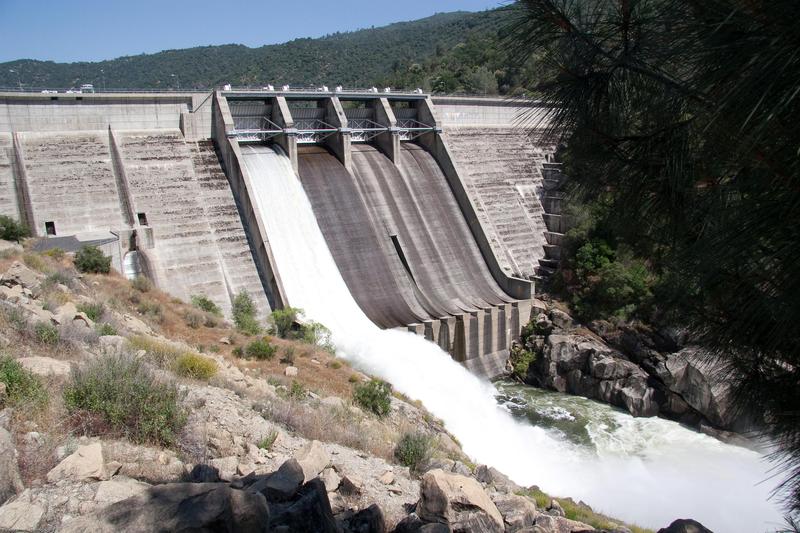
You can launch near the dam by walking down a short road then descending slabs to the pool below the spillway. However, the slabs below the spillway tend to be very slippery from the spray and algae. There is a safer trail and stairway that leads to a gauging station. Look for this trail at the gate blocking the short road down to the dam. Launching here allows you to run a big serious drop in Reddinger Gorge.
Take out: any where at Kerchoff Reservoir. There is a large turnout on the northwest side of the highway bridge and a decent take out underneath this bridge. It is a short carry with kayaks from the water up to the road, but rafters usually paddle across the reservoir to good beaches with easy car access. The shuttle is about 4.5 miles on a paved one lane road. Allow 15 minutes driving time each way.
Amenities:
Toilets and primitive campsites are available at Smalley Cove campground on Kerchoff reservoir. People also seem to stay overnight at the several obvious places along Kerchoff reservoir. Toilets are also available near the boat ramp on Reddinger Reservoir, just past the dam. There are a number of areas suitable for primitive camping near the put-in, but signs discourage camping outside of "designated campgrounds". No "designated campgrounds" are marked at Redinger and the areas near the toilets are barren parking areas suitable only for motorhomes.
There is a grocery store, several decent resteraunts, even a library in the nearby town of Auberry, up the hill to the south of the take out. Ten minutes further are more stores and restaurants at the shopping mall in Prather, at the junction of Auberry Rd. and Highway 168. To the north, are store and resteraunts in the the town of North Fork. Cell phone reception is pretty good (for some networks) at the top of the shuttle road, but there is no reception at the put in or take out.
FERC Information: Redinger Reservoir and Big Creek #4 powerhouse operate under FERC license # 2017 reissued in December 2003.
Scheduled whitewater releases were negotiated as part of the license, but their implimentation is dependant on the outcome of ongoing studies of the native aquatic species. Below are links to the study reports:
2010 Study Report
2012 Study Report
2013 Study Report
Threats to the River:
The downstream area of the San Joaquin is presently under study for several potential large dam and reservoir sites which could also affect this section of the river. See: Upper San Joaquin Basin Storage Investigation Three sites are under serious investigation! One site is about one mile upstream of the confluence with Finegold Creek and could have a maximum size of around 2.1 million ac/ft. Another site is downstream of Temperance flat and could be as big as 2.7 million ac/ft. The last site is upstream of Squaw Leap about halfway through the Patterson Bend section. This would only contain 1.4 million ac/ft. Despite their size, maximum annual yield is only 200,000 ac/ft. All of these reservoirs will bury the Patterson Bend section and will also bury some or all of the Horseshoe Bend section. Maps from the study showing the sizes of the proposed reservoirs are linked below.
A speech by Gary Bobker of the Bay Institute, gives some arguments against building new dams at these locations.
Paul Martzen
Guidebooks: Cassady & Calhoun, Holbek & Stanley
Chris Labounty comments:
Ran Horseshoe on Sunday (May 29, 2005) with a stomping flow (10,000 cfs). Redinger had one door full open, and a second maybe half way. Big water, confusing currents, and random whirlpools that liked to try to turn you sideways or backwards right above holes. I can't recall a time I've ever had to fight so hard to catch eddies, but I scouted about 5 times. Scouting Big Dog was near impossible, as the big river right eddy appeared to be at a higher elevation than the current going past. There was one enormous hole a little ways before Little Dog that took most of the right half of the river. An exciting run to say the least, and I look forward to doing it again at a downshifted flow. Interestingly, later in the afternoon, they had shut off the second door of the damn and took things down a notch from the looks of the 1st rapid.
Local Clubs:
For more information on this and other local paddling areas, please feel free to contact these local clubs: NEW Kayak Club, or Gold Country Paddlers.
Online:
You can get more information from California's Whitewater Community at boof.com.
Rapids in this Run (16)
 Rapid
Rapid
Redinger Dam
Rapid
V
Redinger Gorge
Rapid
Staff Gage
 Rapid
IV
Rapid
IV
Study rapid
 Rapid
III
Rapid
III
Scenic Corridor
 Rapid
III+
Rapid
III+
Two Holes Hiding
Rapid
III
Rapid
Rapid
IV
Long and Shallow
Rapid
Backbone Creek
 Rapid
IV
Rapid
IV
Four Holes
 Rapid
IV
Rapid
IV
Little Dog
 Rapid
V
Rapid
V
Big Dog
Rapid
III+
Wa Hoo!
 Rapid
III+
Rapid
III+
Constriction
 Rapid
III
Rapid
III
Soul Surfer
Rapid
II
Big Creek #4 Powerhouse
Hazards & Portages (1)
Caution: The following locations may require scouting or portaging. Always check current conditions.
Difficulty
Class III-IV(V)
Length
7.0 mi
Gradient
33 ft/mi
max 50
Rapids
16
1 Hazard
Access Points
Shuttle Info
The shuttle road between take out and put in is short, but windy and narrow, so it takes around 15 minutes drive time each direction. The road is paved.
From the south, the take out is about one hour drive time from downtown Fresno on excellent highways.
From the north take highway 99 to Madera and cut off to 145 to highway 41. It appears to be about the same amount of time to go north on 41 to North Fork road and then south to Kerchoff reservoir, or to continue on 145 to Millerton road to Prather, then north to Auberry and down to Kerchoff.
Difficulty Classes
I Easy
II Novice
III Intermediate
IV Advanced
V Expert/Extreme
VI Unrunnable
Current Conditions
5-Day Forecast
Whitewater data from
American Whitewater
American Whitewater