3. Leavenworth to Cashmere
Gauge Conditions
Runnable: 2,500.0 – 20,000.0 CFS
Data from American Whitewater & USGS
Run Map
Run Time Estimate
Select put-in and take-out to estimate time.
Plan This Trip
See wind-adjusted speed maps, forecast planning, and detailed time estimates.
Sign in to generate an AI timing estimate for this run.
Whitewater timing varies with scouting, portages, and group pace. Use as a planning baseline.
Description
As the winter wears on, west-side boaters dream of the big Wenatchee play waves, sunny eastern Washington skies, and lounging on the grass at the Cashmere take-out. The most popular season for this run is late spring as soon as the snow melt kicks into gear, through the summar as long as snowmelt lasts. Don't expect to find either solitude or a scenic wilderenss setting. While this run has some of the best playboating in the state, it's not uncommon to find yourself waiting in lines in the eddies (often you can get the river to yourself on weekdays or during the early morning on the weekend). Apple orchards have dominated the streamside vegetation here but over the years they have transitioned to home site as riverside land has increased in value. It's hard not to enjoy the experience though and for those feeling the need for an audience or a look at the season's newest playboats (or the museum pieces the old timers bring out) this is the place to find it.
*Leavenworth Town Segment, 2 miles, class II*
The first segment in town from the Icicle Creek Road Bridge features the easiest whitewater as the river calms down after its wild romp down Tumwater Canyon. While the water is swift and cold in the spring, these section is often enjoyed by tubers and SUPs in the summer when the water is a little warmer.
*Leavenworth to Peshastin, 5 miles, class II-III*
Starting in Leavenworth the first major rapid is Boulder Bend which is just downstream of the Highway 2 bridge. At higher flows you can find some good surf waves and dodge a few holes on the outside (river left) of the bend. Be aware of wood hazards which can collect along the river left shore. Those looking for the easier line can stay to the right on the inside of the bend.
Once you get through Boulder Bend, the river is mostly swift flatwater for a few miles until you get to Peshastin. Happy Wave, a fun little surf spot on river right with it's on private access point is on this section. Paddlers can get permission to use this for park and play by joining the Happy Wave Beach Club.
*Pehastin to Rodeo Hole, 5.5 miles, class III*
If you have less time, the flows are lower, or you want to focus your time on the best rapids, Peshastin makes a popular starting point for many trips.
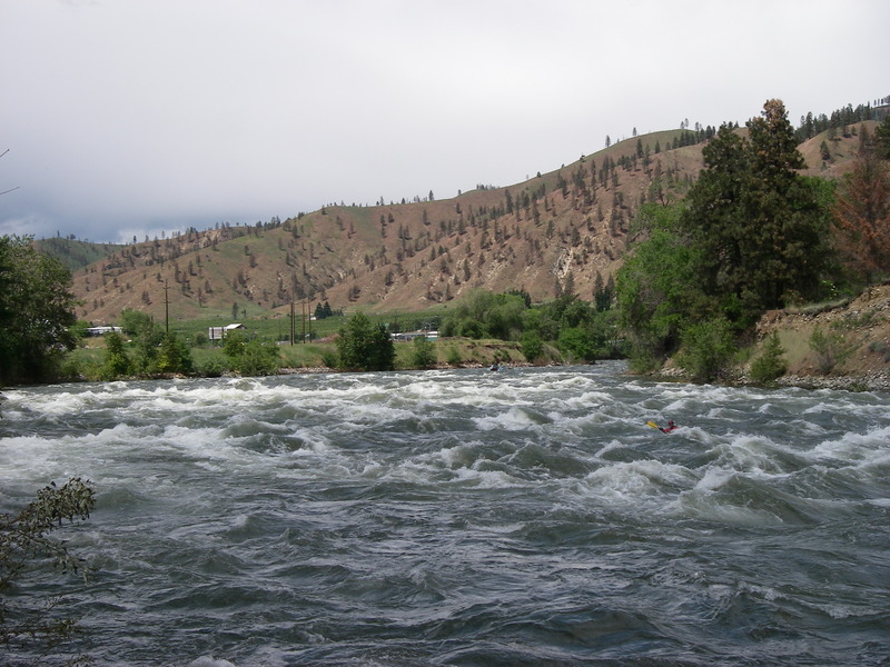
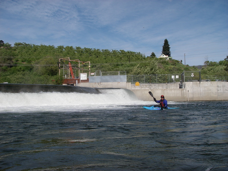
Below Peshastin, the first major rapid is Rock and Roll. This 200 yd. rapid is typical of those on the Wenatchee with a big wave train and a big hole--on this rapid it forms right of center and is known as Satan's Eyeball. The river continues along at a moderate pace until you reach the lowhead dam where Peshastin Creek enters. The terminal hydraulic that forms at the base of this dam is a drowning machine (especially on river right) except at the lowest flows. The concrete structure of the dam is easy to see from upstream and the portage trail is on river right. The sneak that develops around the left at some water levels is for regulars--don't try it unless you know the line, have the skills to execute it, and understand the dangers associated with lowhead dams.
After the dam, the river flows through the rural landscape to the first of many highway bridges below the dam. This is one of the first places where you'll see a line of brightly colored kayaks as there is some good surfing to be had on a couple smooth glassy waves that form on river right just upstream of the bridge at Auto Return. From this point on, the river presents an endless supply of class III rapids and excellent catch-them-on-the-fly surf spots.
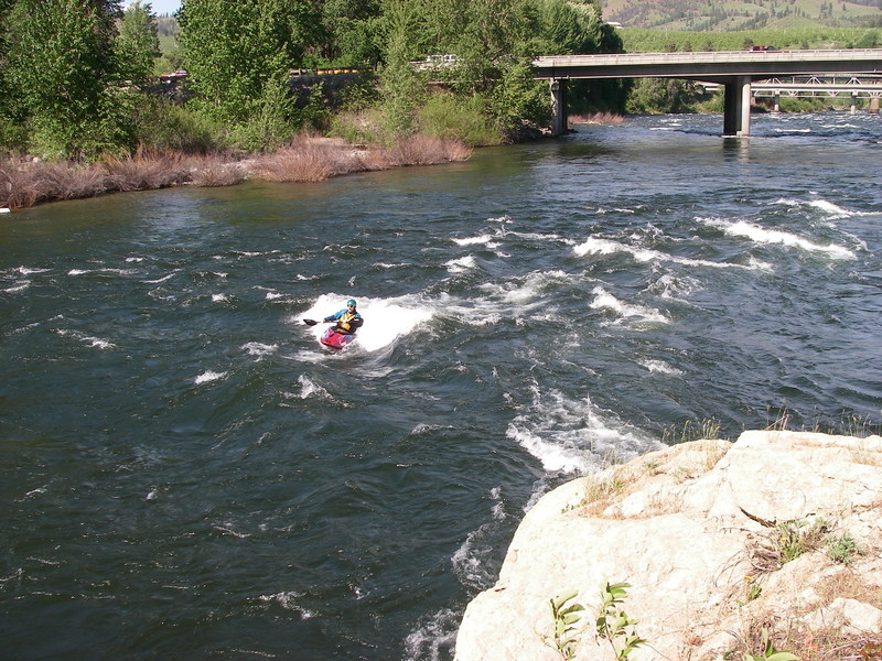
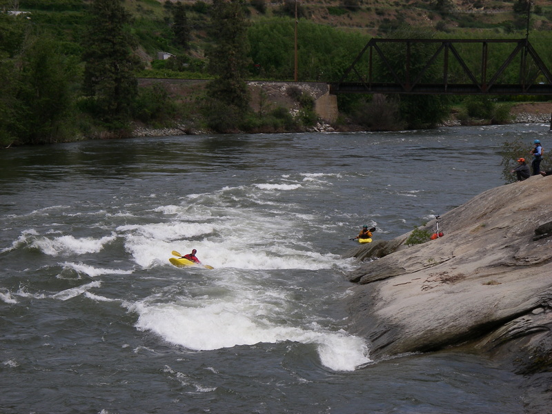
The next significant spot to stop to show your stuff is Rodeo Hole. It's just upstream of the third railroad bridge (about 4 river miles downstream from the lowhead dam). You can recognize this spot by a large granite face (room for a couple dozen spectators) that slopes down to the river on the right hand side. This is a popular stop for lunch and surfing so if the water is at a good level (best above 10,000 cfs) expect a crowd in the eddy and a group cheering from the rock.
R*odeo Hole to Leavenworth, 4 miles, class III*
You can access the river at Rodeo Hole at standard flows paddle up to surf in the hole. Accessing the river here is a popular option for those who want to maximize their playboating time.
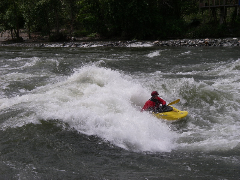
Drunkard's Drop follows a short distance around the corner from Rodeo Hole. It's recognized by a large dirt cliff on river left and a big wave train extending downstream. The photographers will be shooting as you come through Drunkard's. Hop onto Pit Stop, the big wave at the top that you need to catch on the fly. From there you can eddy out for the opportunity to surf the waves at Drunkard's Drop. For those in longer boats you may be able to catch the waves from the eddy on river right at around 5,000 cfs and you can even find some fun stuff around 3,000. As flows rise above 10,000 Trinity Wave over on the left side is where the action is.
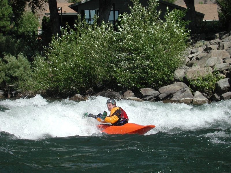
The next significant feature on the run is a surf wave on river left known as Turkey Shoot. This is one of the best spots in the state to hone your playboating skills. A friendly feature with easy eddy service that is great at a wider range of flows than any other feature on the river, makes this a popular stop.
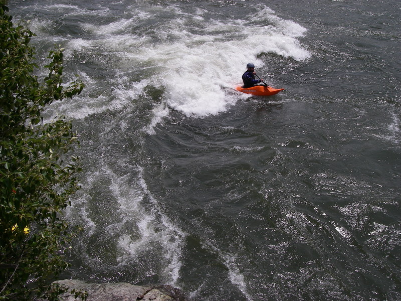
The last formidable rapid on the river is Snowblind. If you're looking for a clean line, this is one of the more technically challenging rapids on the river as there are several waves and holes of different sizes to be negotiated. Otherwise you can punch through just about everything although there are a couple holes that get a little intimidating at some water levels. You can find some decent play in this rapid but for most of it you only get one shot. Granny's is a short distance downstream before you cross under the highway bridge into Cashmere. The waves here provide some of the best surfing at low water and you typically have decent eddy service at the gravel bar to river left of the wave, but look out for Suffocator right below. It will either provide you with some great play or eat you for lunch depending on levels and your skills. Once under the bridge look for the takeout ramp on river right.
Here's what Clay Wright has to say about this great springtime play run at flows around 12k:
'Today the Rodeo Hole is kickin' and we're going big on past-vert blunts to the right on river right - there is actually a tube at the very corner to kick you around hard. Out on river left we're popping straight airs -air blunts, clean blunts, back air blunts, flip turns, and donkey flip/ air screws. Trinity wave is huge too, and some BIG air was had, but lots of workings too. Very fast, so kinda violent when you flip. Snowblind is chock full of surfing - too many holes to hit in one round. Too bad you can't walk back up! Suffocator wave at the end is now a breaking wave and we're hitting air blunts on that too. Working the 'Macho move' a downstream loop off a wave-train between rapids, and of course the kickflips are flying high too. Gotta go - second session leaving soon.'
Logistics:
There are basically three different common put-in options depending on your preference for a longer run or a shorter run that concentrates on the best play features.
1 - River Cruisers: When the flows are high, or if you just want to spend a long day on the river, you can put in at the access in Leavenworth. This access is upstream of the Highway 2 bridge across the Wenatchee (near the Safeway) on river right. Follow East Leavenworth Road 0.7 mile up to the public access with a big parking area. The most popular put-in for those who want to run the river and take in the best features, particularly if flows are below 10,000 cfs, is in the town of Peshastin (you'll need a Discover Pass to use this access) which gives you about an 8 mile run. At Highway 2 mile 103.6 turn east on to Main Street and cross the bridge into the town of Peshastin. After you cross the river, turn right onto School Street. Continue past the school and down the gravel drive to the river access on river left. The put-in is on the edge of a residential neighborhood and was nearly closed after complaints from locals. Drive slowly through town and use discretion when changing here. Although the put-in is a little dusty, the take-out at Riverside Park in Cashmere is first class. A ramp runs right down into the water making it a simple task to get out on shore and find your way over to the crowd of boaters sitting out on the grass. Here you can enjoy the seemingly endless supply of chips and cold beverages that seem to emerge from shuttle vehicles. There are picnic tables and changing rooms here. To reach this takeout take Highway 2 to mile 111.1, turn west onto Aplets Way, and cross the bridge into Cashmere. Turn left and work your way towards the river (the park is downstream river right of the bridge). Although most kayakers have had enough by the time they get to Cashmere, there is another takeout at Wenatchee River County Park in Monitor.
2 - Play and Cruising
For those who want to shorten the run a bit (by about a mile and half) you can put- in at the base of the diversion dam where Peshastin Creek enters the river. Turn off from Highway 2 just south of the Highway 2 bridge across Peshastin Creek (at Highway 2 mile 105.2) and follow Saunders Road 0.3 miles back to Peshastin Creek. Turn right before you cross the creek onto a road that takes you 0.4 miles to an unimproved parking area next to the dam that was recently acquired by WDFW (the good news is the access, which was previously owned by DOT and threatened for closure or possible sale, will remain public but it now requires a Discover Pass. You can also combine the big water of the Wenatchee with a creek boating entry by boating Peshastin Creek down to the Wenatchee. Use the same take-out in Cashmere as described above.
3 - Playboaters
A final option for a put-in that is popular with the playboating crowd is to put-in at Rodeo Hole. This is a much shorter run (4 miles) but you can spend as long as you want at all of the best rapids. To reach Rodeo Hole directly, turn north on to Johnson Road at mile 106.5 off Highway 2 (it's easy to miss this turn--it's right by the sign to Dryden). Take an immediate left on to Frontage Road which then becomes Stine Hill Road. On the way to Rodeo Hole you will dip down close to the river at one point just upstream of the trailer park and this roadside access has been used by folks who don't have a vehicle access pass, but most continue on to the main parking area. In 1.7 miles from the Highway 2 turn-off you will see a cream colored house with a blue/gray roof (as of 2012) at a break in the guardrail. Head down the gravel drive to the north side of the house, 0.2 miles through the orchards, and down to the public parking area near the railroad bridge (you'll need Discover Pass to use this access, yes they do check and you will get a ticket). Rodeo Hole is a couple hundred yards upstream of the railroad bridge. If you're using this access you'll probably run your shuttle on river right. It's 3.2 miles to Cashmere and you'll pass an excellent taco stand. Continue on downstream on Stine Hill Road which becomes Sunset Highway. When you get to Cashmere turn left and cross the railroad tracks. After crossing the tracks take your second right and follow it about a block and half to Riverside Park.
for additional information see
- Bennett, J. and T. Bennett. 1997. A guide to the whitewater rivers of Washington, second edition. Swiftwater Publishing. Portland, OR.
- North, D.A. 1992. Washington whitewater. Mountaineers. Seattle, WA.
Rapids in this Run (15)
Rapid
Trout Unlimited Park Put In
Rapid
Waterfront Park in Leavenworth
Rapid
III
Boulder Bend
Rapid
II
Happy Wave
Rapid
Peshastin River Access
Rapid
III
Rock and Roll/Satan's Eyeball
Rapid
Dryden Dam Access
 Rapid
II
Rapid
II
Auto Return
Rapid
Roadside
 Rapid
III+
Rapid
III+
Rodeo Hole
Rapid
Rodeo Hole Access
 Rapid
III
Rapid
III
Drunkard's Drop
 Rapid
III
Rapid
III
Turkey Shoot
 Rapid
III
Rapid
III
Snowblind
 Rapid
III
Rapid
III
Granny's/Suffocator
Hazards & Portages (1)
Caution: The following locations may require scouting or portaging. Always check current conditions.
Difficulty
Class III+
Length
17.0 mi
Rapids
15
1 Hazard
Access Points
Difficulty Classes
I Easy
II Novice
III Intermediate
IV Advanced
V Expert/Extreme
VI Unrunnable
Current Conditions
5-Day Forecast
Whitewater data from
American Whitewater
American Whitewater