3. Marmot Dam site to Revenue Bridge
Gauge Conditions
Runnable: 400.0 – 5,000.0 CFS
Data from American Whitewater & USGS
Run Map
Run Time Estimate
Select put-in and take-out to estimate time.
Plan This Trip
See wind-adjusted speed maps, forecast planning, and detailed time estimates.
Sign in to generate an AI timing estimate for this run.
Whitewater timing varies with scouting, portages, and group pace. Use as a planning baseline.
Description
Widely known as the Sandy Gorge, this section is gorgeous, enjoyable at a wide range of flows, and really close to Portland. It has been run down to 200 cfs, but most people prefer it over 800 cfs. The run is most difficult in its teens (1300-1900 cfs) and turns more playful above 2,000. The riverbed is dynamic, with rapids changing during every flood, and wood obstacles that shift on a daily basis. Visitors are advised to seek current local information rather than relying on this writeup.
Parking at the takeout (at intersection of Kubitz and Ten Eyck Roads) is limited and the locals are not happy about the increase in boater use. If you are coming here with a large group, please meet in the town of Sandy, dress out, and consolidate boats and paddlers to the minimum number of vehicles. This way you can simply drop off your takeout car on your way by and minimize both the time spent and the number of cars left. Please avoid worsening the mud problem. Please minimize nudity at the takeout parking. Build bridges not bonfires.
There are several possible put-in locations. Some boaters launch downstream from the log jam by parking at the first large pullout on the right when Big Sandy Dam Road levels out. Be prepared to line boats down a short steep section of trail. If you continue driving to the next major pull-out (after the gate which stays open, identifiable by the concrete blocks) there is an old road down to several short trails that access the water above the log jam by ~1/4 mile. If you drive all the way to the end of Big Sandy Dam Road there is a gated park, open only in summer, which adds a mile of enjoyable class III to the run. If the gate is locked, simply shoulder your boat, walk around the gate and enjoy the 10 minute hike in on the road and access the river just downstream of the bridge at the Marmot Recreational Site.
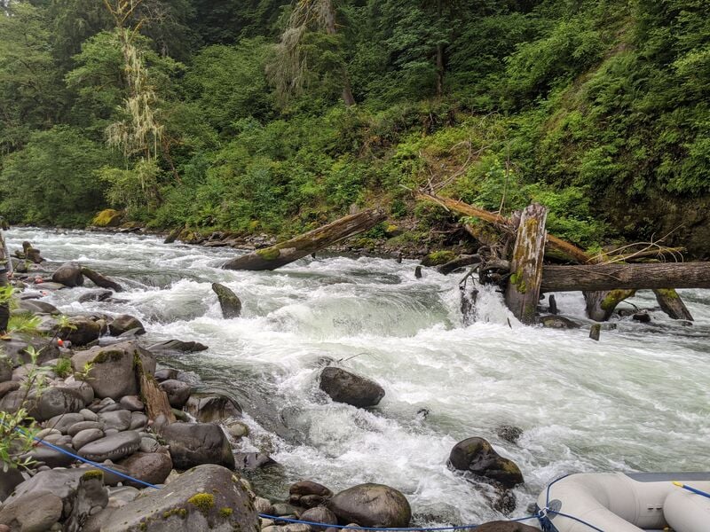
From the Marmot Dam site the river flows through straightforward whitewater down to the '64 Logjam where giant trunks block the main channel and can collect additional debris. Scout right. In the past, '64 Logjam was almost always portaged on the right but as the wood has rearranged over the years, clear lines exist at almost all flows. At very high water (>4,000cfs) a runnable channel opens up to the right of the cobble bar. There is another 2 miles of class III whitewater with one long class III+ before you reach the first class IV: Boulder Rapid.
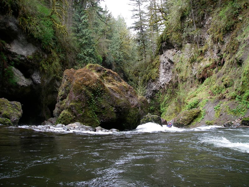
When the river disappears into a magical gorge with hanging gardens that drape down the sides of the bedrock walls, you are at Boulder Rapid. This rapid is full of undercuts and sieves, and the slots on the right collect wood. It can be run both left and right depending on flows, wood, and your skills. Most people run it in the channel immediately left of the giant Boulder.
Scouting Boulder is tricky. If you're curious about the rarely-run right side channels, climb high on the cliff on the right. When the river goes out of sight, assume that it piles into a sieve. Scouting from the left boulders may mandate a partial portage because you can't get back to the entrance. A spooky but easy sneak (narrow with blind corners, in the dark under the cliff) goes far far left to a point midway down the rapid. This sneak is a good option when the regular channel is obstructed. If you get in there and run out of water, you can get out and drag. At very low water a gravel bar emerges upstream from the largest Boulder and is a good place to stop and look around.
Rasp Rock is the next named rapid. Here the gradient steepens, the channel narrows and there are some holes to negotiate. The rapid begins with a fast slide down the middle of a small ledge. About 50m below this opening ledge, the river narrows and then is divided by 2 rocks forming 3 channels. There is a good scouting eddy on the left before this bottom section. Wood can be present in any of the channels but generally the right channel is preferred. The giant hole that used to form here at high flows has not been seen much in recent years as the riverbed has changed again.
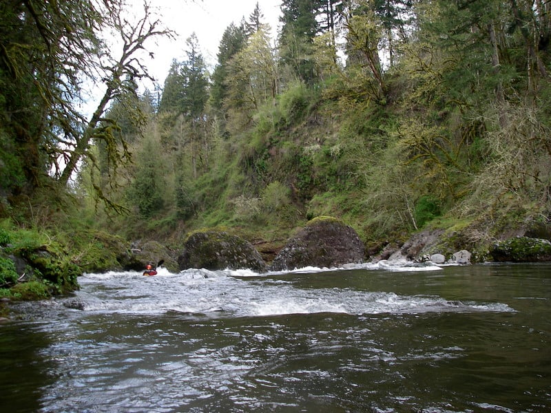
Drainhole comes up next and it's worth a scout, especially if it's your first run, or it's lower water than you've seen. It is a dangerous class IV with a nasty undercut on the left that is harder to avoid at low water. To the right of this undercut is a line of large boulders forming narrow slots and collecting wood. The water accelerates down a steep ramp toward the undercut and the goal is to hit the eddy on the right at the bottom of the ramp. The farthest right slot around the line of boulders at the bottom is largest and most often run.
Scout Drainhole on the right if you're likely to portage, because then you can just shoulder your boat and go. Scout left if you think you might run it, because you get the best view of the rapid. For those who already know the run, you can see most of the rapid from the last eddy on the left.
You will known Revenue Rapid by the bridge coming into view. The rapid is much bigger than it looks from the bridge. It has two parts: a messy boulder pile at the top and then a big water finish. The boulder pile often collects wood, so scout from left or right (or both) to detect blockages. You really can't see the routes from shore, so the best way to find a route is follow someone who has been there recently. The portage is on the left. This rapid is constantly changing. There are multiple options to get through the top rocky section although many of them are messy, particularly at low water. The relatively Straight Shot (where rafts can get through at 1500 and more) just to the right of a rounded boulder at the very top of the rapid is very common. There used to be an option on the far right along the wall but it has mostly been filled in at the top although still probably do-able at higher water. There is also usually an option that hooks around the back of the rounded middle rock from the left but that is rockier than it used to be. After the rocky top part the water piles into the right wall, and then there are eddies on the left above the big water bottom part.
After Revenue rapid the take-out comes up immediately on river left, either upstream or downstream of the bridge. Climb up to the road via trails beside the bridge on either side and be courteous to locals as there have been hostilities. Carry your boats up to the parking area at the junction of Kubitz Ave and do not park or load up at the junction of Dusty Lane. Do not get naked or urinate in public here.
Logistics:
From Highway 26 in Sandy turn north onto Ten Eyck Rd. Follow this road 1.9 miles down into the Sandy gorge and the Revenue Bridge. This bridge is the take-out where a trail leads up from the river on the downstream river left side. Parking is extremely limited and local landowners have complained about the congestion--plan to meet and consolidate vehicles somewhere in the town of Sandy and be quick and efficient with your load and unload. Don't block driveways or tear up the shoulder. A few parking spots are available by heading back up the hill a few hundred yards to the intersection of Ten Eyck Road with Kubitz Road.
To reach the put-in continue on Ten Eyck Rd. another 0.2 mile and turn right onto SE Marmot Rd. Head 4.1 miles to the BLM access road at 48770 SE Marmot Rd. Turn right onto this road and head down the hill to one of several possible launch spots. It's 1.3 miles down to where the road levels and the first pullout on the right is where you can access the river downstream from the logjam. Cross the gully and drop down to the left to get to the water. The second pullout on the right where the concrete blocks are is also used by following the road down to one of several trails that head off to the right and down to the water. Continue to the end of the road for the full run, park in one of the spaces on the south side of the road and begin your hike around the gate down to Marmot Recreational Site.
In October 2002 American Whitewater signed the Settlement Agreement resulting in the removal of Marmot Dam in 2007 and restoration of this river for fish, wildlife, and recreation. We are continuing to work with our partners to realize the full potential of this spectacular river as Bureau of Land Management develops the management plan for lands previously owned by Portland General Electric that have been transferred to public ownership.
Additional Information:
Some pretty but outdated photos are available on the Sandy River Gorge page on Jason Rackley's Oregon Kayaking site. Rasp Rock has changed a lot since then.
Difficulty
Class III-IV
Length
6.2 mi
Gradient
40 ft/mi
Rapids
6
Access Points
Difficulty Classes
I Easy
II Novice
III Intermediate
IV Advanced
V Expert/Extreme
VI Unrunnable
Current Conditions
5-Day Forecast
Whitewater data from
American Whitewater
American Whitewater