3. Schaghticoke Dam to Powerhouse
Gauge Conditions
Runnable: 1,200.0 – 4,000.0 CFS
Data from American Whitewater & USGS
Run Map
Run Time Estimate
Select put-in and take-out to estimate time.
Plan This Trip
See wind-adjusted speed maps, forecast planning, and detailed time estimates.
Sign in to generate an AI timing estimate for this run.
Whitewater timing varies with scouting, portages, and group pace. Use as a planning baseline.
Description
Contents:
Overview
Flow Study Completed! American Whitewater at Work!
Directions
Scouting the Upper Gorge (and portaging around it)
Conduct at Put-in and Take-out
Put-in
Take-out
Whitewater Releases
Overview:
----------
Note: As of 2016/2017 the dam operators have fenced off the area around the gorge and do not allow access except during a single yearly scheduled release (see below). Running this section on any other day would involve trespassing. AW members are currently working to restore access.
\-\-\--------
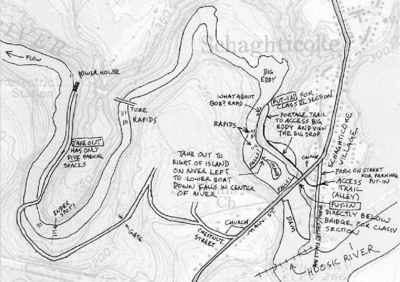
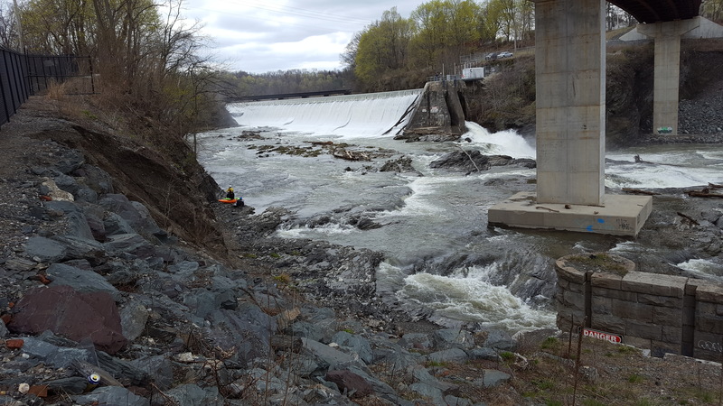
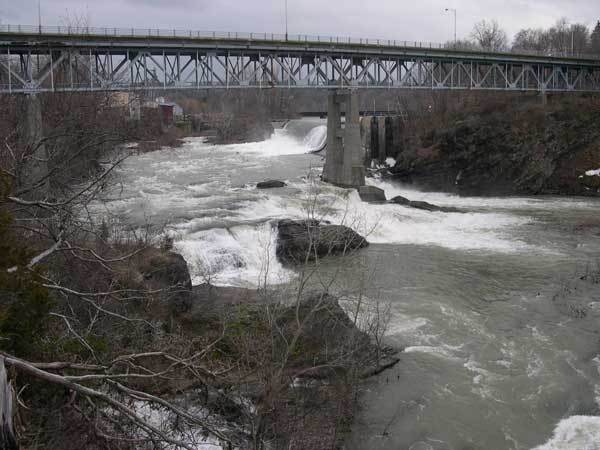
A dam in the town of Schaghticoke diverts the flow of the Hoosic river to generate electricity, de-watering the gorge. When flow exceeds generation capacity (about 1600cfs) the remaining water enters the gorge and paddling becomes possible. The gorge drops about 150 feet in total, but most of that gradient (100 feet including the dam) comes in the first 4/10 mile. There are two distinct sections to the gorge, the upper and the lower. The upper can be run alone, it can be portaged and the lower run alone, or both sections can be done together. A trail runs through the woods beside the upper gorge all the way to The Big Eddy and should be used for scouting.
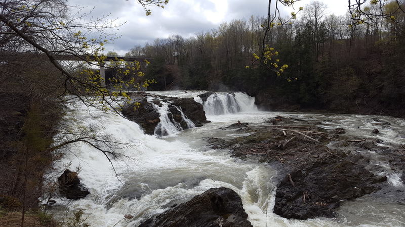
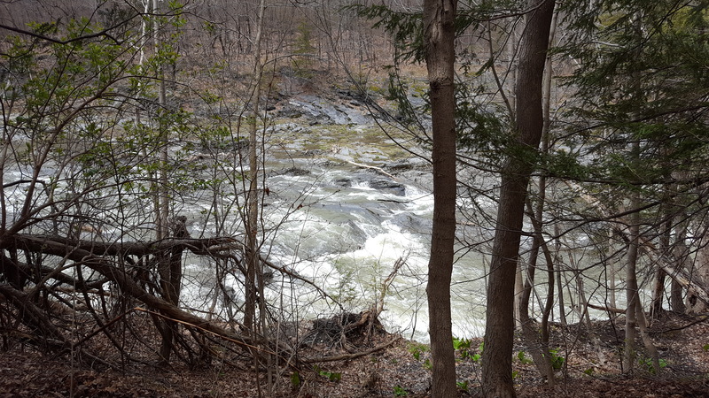
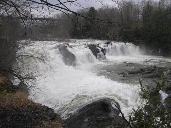
The upper gorge consists of a class IV drop, a class V waterfall, a section of unnamed class III+, and a final class IV. The first drop is under the Rte 40/67 bridge (see photo below "Under the Bridge"). This rapid changed significantly in 2015/2016 when the old bridge was demolished and a new one constructed. The class V falls follows shortly after (see photo below "The Big Drop"). The class III+ runout from the falls leads to the class IV "What About Bob?" which then empties into The Big Eddy. You can take-out at The Big Eddy and walk back to the top of the gorge, or continue down the class II-III lower gorge.
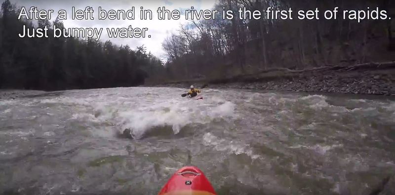
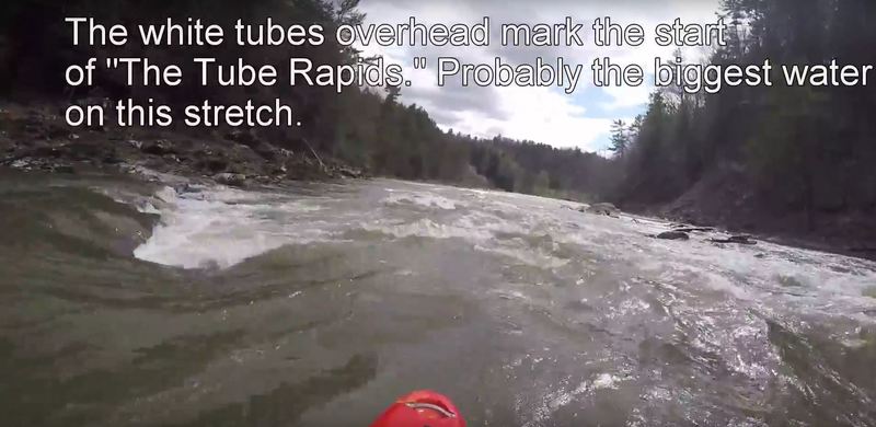
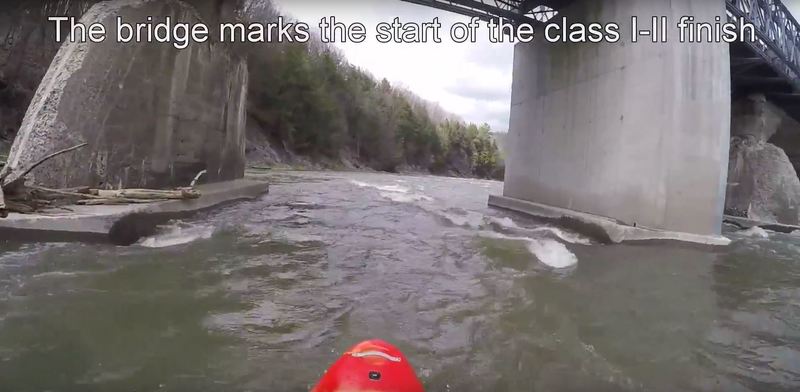
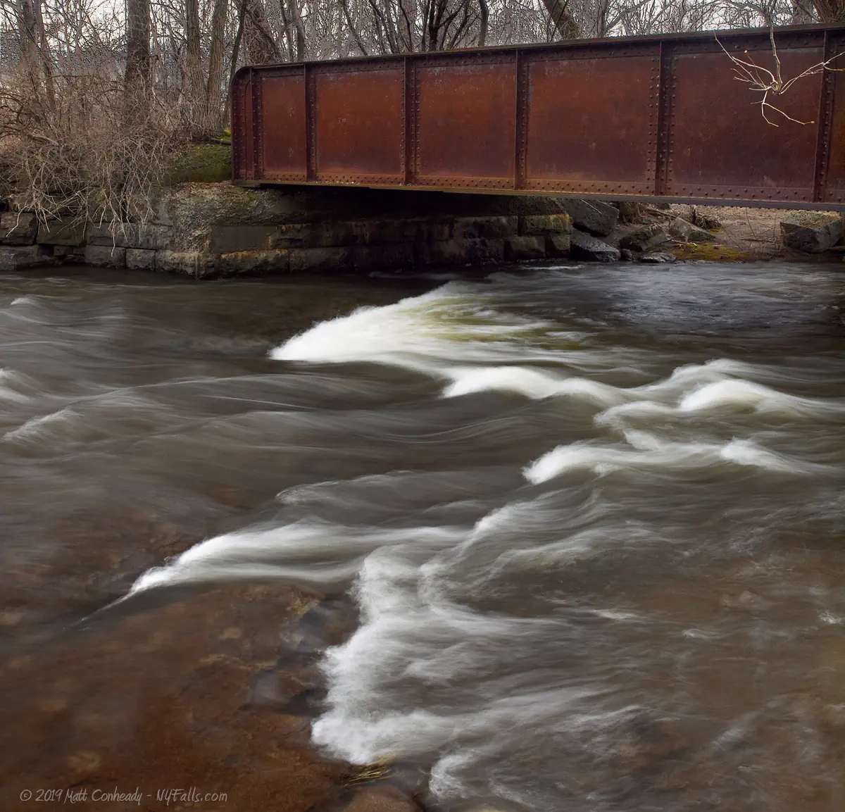
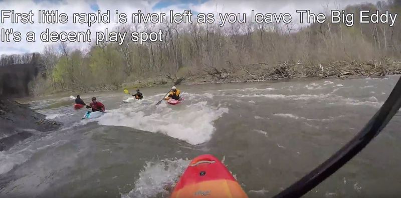
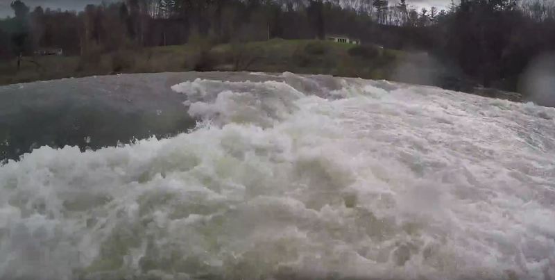
The lower gorge is class II-III and has several potential play spots. It runs from The Big Eddy to the Powerhouse located at the end of Powerhouse Rd. You can skip the upper gorge and put in directly at The Big Eddy (accessible by a trail) or run the upper gorge and continue down the lower. The first small play-spot is river left as you leave The Big Eddy. The first stretch of class II rapids is around a sharp left bend shortly afterwards. You will then pass under the white tubes and enter The Tube Rapids, a set of class III that ends with a large ledge drop and has some potential play spots. Afterwards you will pass under the Powerhouse Rd. bridge and a short series of class II to the take-out.
Caution: Most of the rocks here are sharp slate.
Flow Study Completed! American Whitewater at work!!! On June 10 & 11, 2003, a flow study was conducted by American Whitewater with the cooperation of Reliant Energy. Participants included members of the American Whitewater and the Adirondack Mountain Club as well as open boat paddling legend Jim Michaud. John Gangemi did a fantastic job organizing the event. He coordinated getting John Duncan and Jason from Sacandaga Outdoor Center to participate, and they were critical to the success of the flow study by providing shuttle transportation with their van and trailer. (Not to mention that Jason really helped me out by fishing me out of the whirlpool.) Thanks to Aaron for participating despite the last-second notice. (Sorry about the pieces of shale in your boat, Colleen!) Without the success of this flow study, we could not have demonstrated the whitewater potential of the gorge, and Reliant Energy probably would not have had to have any releases scheduled at all. Water was released into the gorge from the gate on the far river left end of the dam. Over the two days, four flow levels were investigated. Because of the location of the release, the rapids under the bridge (see photo) were not available. Until this flow study, it was not known what the exact potential for whitewater recreation was. As a result of the flow study, we know that the Hoosic Gorge is a fantastic whitewater resource! Every drop was run. Only one line on Big Drop was run, but it was run by several people. One of the rapids got a terrific name: "What About Bob?" Everyone had fun, and there were only a couple of swims.
Directions to Schaghticoke:
Directions are described in relation to the Rte 40/67 bridge over the Schaghticoke Gorge in Schaghticoke. Take I-87 (Adirondack Northway) to Exit 9. Head east on Rte 146 to Mechanicville. In Mechanicville, take Rte. 67 east across the Hudson river and stay on Rte 67 until you reach Schaghticoke.
Scouting the Upper Gorge (and portaging around it):
A trail runs along the upper gorge on river right down to Big Eddy. The best scouting of the major drops is along this trail. The entrance is down an ally directly across from the restaurant Sammy Cohen's in Scaghticoke. Park on the street not in the alley. The top of the gorge has been fenced off, and the entrance to the trail is straight ahead after passing through the fence gate. For those wishing to portage the upper gorge, continue all the way to The Big Eddy. Numerous sports along the trail provide good scouting vantage points of the river.
Conduct at put-in and take-out:
There is limited parking in the town of Schaghticoke and at the take-out. In Schaghticoke try to park on a side street out of respect for the locals--we want to cultivate a positive relationship with the local community. That positive relationship starts with you. On release day the restaurant Sammy Cohen's will sometimes allow parking for those who get a drink or meal afterwards. The United Presbyterian Church of Schaghticoke will also sometimes allow parking on release day. At the powerhouse take-out there is parking for only 5 cars, so be prepared to shuttle. Powerhouse Rd is dirt and goes over a one-lane bridge so don't plan on bringing a bus or large trailer.
Put-in
There is a trail which runs down the river right side of the gorge. You can get to trail by taking your first right after crossing the bridge heading north. Street parking is available. There is an alley way across from the bar. Carry your boat to the down the alley. Just under the bridge there is a steep trail to carry your boat down to the drop under the bridge. During releases, start there. To get to the put-in for the Class III section at Big Eddy, continue to carry down the trail until you get to the river. Great views of the upper part of the gorge are available along this portage.
Take-out
GPS coords (see below) refer to the powerhouse at the end of the gorge. From the gorge bridge, head SW again, and take a right on Chestnut Street. Keep bearing left to wind your way down to river level. Proceed along at river level to cross the Hoosic to get to the powerhouse. The two land-owners on this road to the take-out did not want to grant the public easement during the relicense process. The Federal Power Act requires public access to the project. Rather than force the issue legally we reached a settlement agreement whereby parking is limited to 5 vehicles. The objective of limited parking is to reduce traffic on the road to the powerhouse. Boaters need to be conscientious and respectful of this desire of the local landowners on this road. Coordinate shuttles with other boaters. Overflow parking is available at the Church on Chestnut street. Drive 20 mph or less on this road--speed limits in excess of this will jeopardize relations with these land-owners and potentially future releases. Be sure to educate other boaters that may not have read this web page or are slow to learn that their actions affect perceptions of the sport in general.
Whitewater Release Schedule:
American Whitewater negotiated five whitewater releases in the relicense process. These releases started in spring 2004. For the first three years there was one whitewater release annually starting the first Wednesday evening (5 PM to 8 PM) after April 15th. In year four, additional releases will be added (up to five total) provided twenty-five or more boaters attended each release in the year prior. In the event that ten or fewer boaters attend a release one release will be subtracted from the annual total. Upon two or more releases the schedule will alternate between Wednesday evening (5-8 PM) and Saturday (1-4 PM).
In 2011 a release was conducted after several postponements and no boaters showed up. As a result, Brookfield Renewable stopped conducting releases until 2017. In 2017 a release was scheduled for Saturday April 22nd. Fewer than 25 boaters came out which means there will be only a single release in 2018 (date to be determined).
Release Levels:
The flow in the gorge is calculated as follows. The gauge at Eagle Bridge is multiplied by 1.254 to get the flow at Schaghticoke. The power company diverts up to 1640cfs to generate electricity. Any remaining flow enters the gorge. For example, if the gauge at Eagle Bridge reads 2000cfs, the flow at Schaghticoke will be 2508cfs. 1640cfs will be diverted for power generation, leaving 868cfs in the gorge itself.
During a release, the dam operators redirect water away from their power generation and back into the bypass (the gorge) until it reaches the recommended flow for boating (between 1200cfs and 1600cfs, typically 1400cfs). If additional water is available they will continue generating power. Releases continue for 3 full hours AFTER reaching optimal flow, at which time water will be diverted back to their power facility and away from the gorge.
Proposed Language from American Whitewater Comments on the Hoosic River Project, FERC No. 2616:
"Licensee shall make a whitewater release into the Schaghticoke bypass from the dam provided inflow to the Johnsonville reservoir is >638 cfs (this is using 1.254 as the multiplier) on the first Wednesday after April 15. I f inflow to the Johnsonville reservoir is >1278 cfs (this is using 1.254 as the multiplier) then the Licensee can resume power generation with the excess water provided 1600 cfs remains in the bypass channel. If inflow to the Johnsonville reservoir is < 638 cfs (this is using 1.254 as the multiplier) then the whitewater release will be postponed until the following Wednesday. If inflows sufficient to trigger a whitewater release are not achieved by November 30th of that year then the Licensee has no obligation to fulfill this license condition for that calendar year. Wednesday releases will start at 5:00 PM."
Use extreme caution! Scout carefully during the releases!
Capital Region Area Reaches
Basic Creek Batten Kill Claverack Creek
Cobleskill Creek Fox Creek Hannacrois Creek
Hoosic Hudson (Lock 2) Kinderhook Creek (1.)
Kinderhook Creek (2.) Kinderhook Creek (3.) Kline Kill
Normans Kill (1.) Normans Kill (2.) North Chuctanunda Creek
Mohawk (Upper Cohoes Wave) Mohawk (Cohoes Wave) Poesten Kill (0.)
Poesten Kill (1.) Poesten Kill (2.) Quacken Kill
Schoharie Creek Stony Kill Wyant's Kill
Google Map of New York Whitewater
New York Whitewater Paddlers Facebook Group
Rapids in this Run (6)
Playspots (2)
Hazards & Portages (2)
Caution: The following locations may require scouting or portaging. Always check current conditions.
Difficulty
Class III+(V)
Length
1.8 mi
Gradient
75 ft/mi
max 200
Rapids
6
1 Hazard
1 Portage
Access Points
Shuttle Info
**Directions to Schaghticoke:** Directions are described in relation to the Rte 40/67 bridge over the Schaghticoke Gorge in Schaghticoke. Take I-87 (Adirondack Northway) to Exit 9. Head east on Rte 146 to Mechanicville. In Mechanicville, take Rte. 67 east across the Hudson river and stay on Rte 67 until you reach Schaghticoke. [Click here for a Google Map from I-87 to the putin.](http://maps.google.com/maps?f=d&hl=en&geocode=9346068922336126177,42.862433,-73.775428&saddr=I-87+S+%4042.862433,+-73.775428&daddr=42.891571,-73.5893478&sll=42.862628,-73.77594&sspn=0.006889,0.014591&ie=UTF8&z=12)
**Put-In**
There is a trail which runs down the river right side of the gorge. You can get to trail by taking your first right after crossing the bridge heading north. Street parking is available. There is an alley way across from the bar. Carry your boat to the down the alley. Just under the bridge there is a steep trail to carry your boat down to the drop under the bridge. During releases, start there. To get to the put-in for the Class III section at Big Eddy, continue to carry down the trail until you get to the river. Great views of the upper part of the gorge are available along this portage.
**Take-out**
GPS coords (see below) refer to the powerhouse at the end of the gorge. From the gorge bridge, head SW again, and take a right on Chestnut Street. Keep bearing left to wind your way down to river level. Proceed along at river level to cross the Hoosic to get to the powerhouse. The two land-owners on this road to the take-out did not want to grant the public easement during the relicense process. The Federal Power Act requires public access to the project. Rather than force the issue legally we reached a settlement agreement whereby parking is limited to 5 vehicles. The objective of limited parking is to reduce traffic on the road to the powerhouse. Boaters need to be conscientious and respectful of this desire of the local landowners on this road. Coordinate shuttles with other boaters. Overflow parking is available at the Church on Chestnut street. Drive 20 mph or less on this road--speed limits in excess of this will jeopardize relations with these land-owners and potentially future releases. Be sure to educate other boaters that may not have read this web page or are slow to learn that their actions affect perceptions of the sport in general.
Difficulty Classes
I Easy
II Novice
III Intermediate
IV Advanced
V Expert/Extreme
VI Unrunnable
Current Conditions
5-Day Forecast
Whitewater data from
American Whitewater
American Whitewater