4 - BZ Corner to Northwestern Park Wild
Gauge Conditions
Runnable: 500.0 – 2,000.0 CFS
Data from American Whitewater & USGS
Run Map
Put-in
Take-out
Rapids/Hazards
Wild
Scenic
Run Time Estimate
Select put-in and take-out to estimate time.
Plan This Trip
See wind-adjusted speed maps, forecast planning, and detailed time estimates.
Sign in to generate an AI timing estimate for this run.
Whitewater timing varies with scouting, portages, and group pace. Use as a planning baseline.
Description
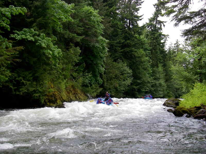
Emerging from the slopes of Mt. Adams, the White Salmon is one of Washington's greatest whitewater resources. With a range of whitewater opportunities from a popular beginner training run to some of the most challenging whitewater in the country this river has something for everybody. Commercial rafting trips are popular on this section and the river typically has good flows throughout the year. With it's consistent and dependable whitewater, the river has hosted many races and events over the years. The water is always cold so be sure to dress appropriately. While mid-day sun penetrates the canyon it is often much cooler down in the gorge particularly on hot summer days in August.
Most rafters run from the BZ Launch down to Northwestern Park but many kayakers take out at Husum or put in at Husum, dividing this section into the 'Middle' or 'Lower' depending on whether they want a class III or a class II experience.
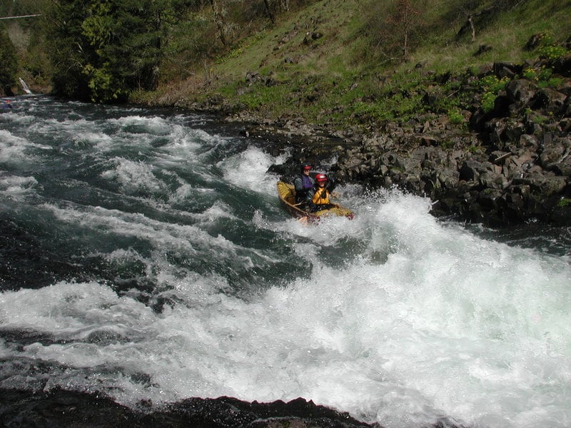
Middle White Salmon, 4.5 miles, Class III+
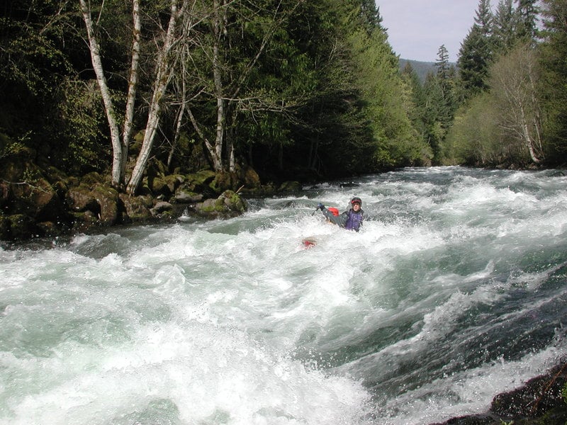
The section starting at BZ Corner is known as one of the best intermediate whitewater runs in the state. With near consistent action, beautiful scenery, and a big drop at the end that always attracts a crowd of spectators, this is a destination for folks from around the region. Those who have been a part of the whitewater scene for the past few decades remember the privately owned put-in located in a residential area along the gorge. A cableway high across the river was used to lower rafts down into the gorge while kayakers and raft passengers paid their fee to hike the trail down to the river. With the future of the access in question American Whitewater partnered with the Trust for Public Land to negotiate a deal and transfer ownership of the property to the Forest Service. The old billboard with the oversized map of the river is gone and a set of rails to slide rafts down along the trail has replaced the cableway, but the land is now in public ownership effectively securing the best possible access point for future generations of paddlers. The Forest Service is always open to user feedback so let them know if you have constructive thoughts on how to improve the access.
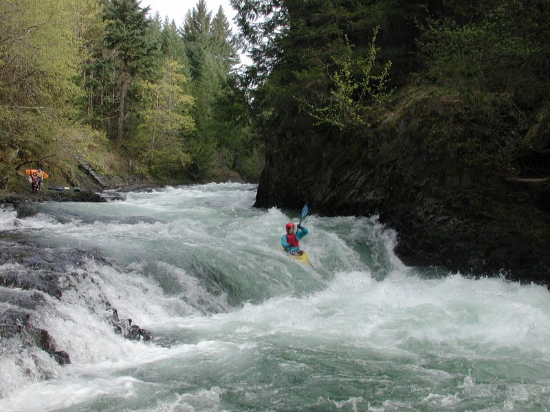
The trail down into the gorge ends at the put-in above a relatively straight forward class IV- drop with two holes. First comes Maytag and then the rapid finishes with a ledge drop into a good-sized hole known as Top Drop. Skirt the edge or punch it through the middle depending on flows. If you prefer a bit of a warm-up before jumping on to one of the more challenging rapids of the run you can always put-in to the downstream end of the drop. Spectators can watch the action from the bedrock ledge at river level or from high above on the Glenwood Road Bridge.
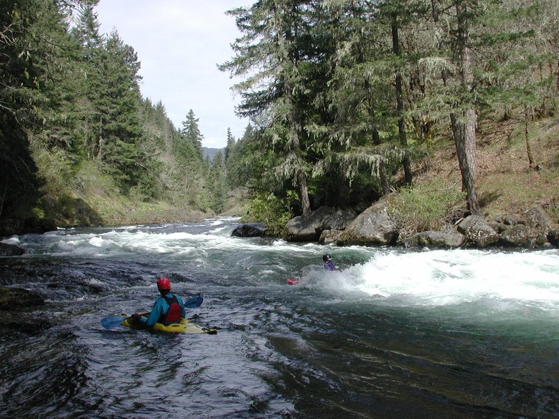
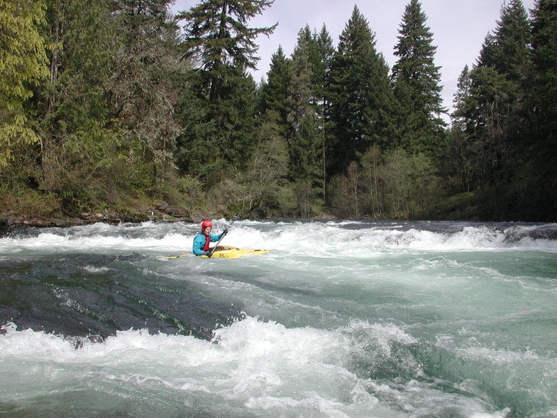
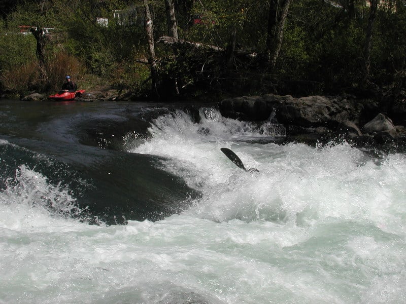
Once you pass under the bridge the action starts right away with several of the best rapids and nearly continuous action for the next two miles. One hazard to be aware of near the start of the run is a cave on river right. Stay to the left away from the wall and you'll be fine. Class III rapids in this section include Grasshopper, Siwash, Corkscrew, and Waterspout. The drops are all relatively easy to boat scout and consist of fun wave trains and ledge drops through the narrow gorge. The hole in Waterspout sometimes gives people trouble for those not expecting it. Punch it down the center or sneak it along the left. The river tapers off for a bit before you reach Stairsteps which is a series of fun ledges. This is the last of the significant rapids before you reach Husum Falls.
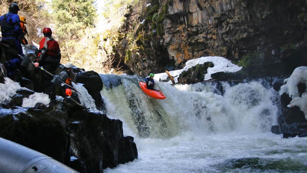
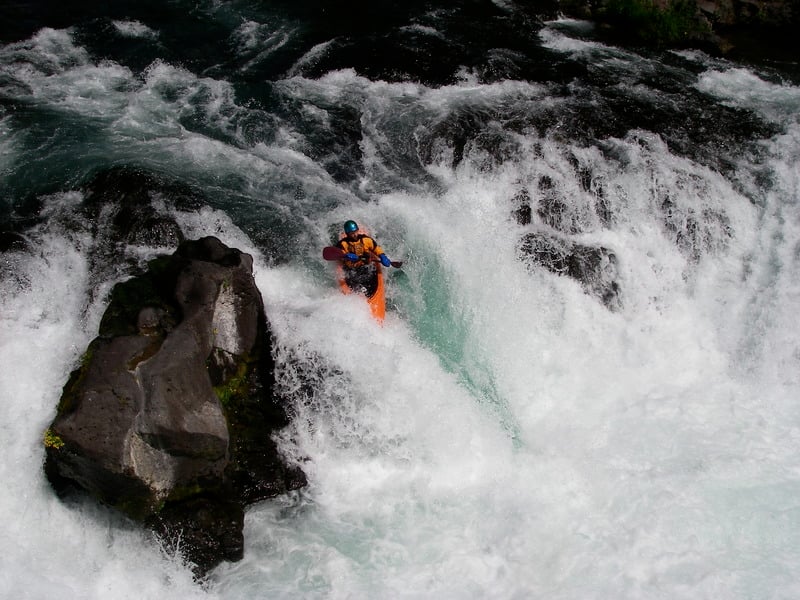
Husum Falls, 100 yards, class V
A sign marks the approach of Husum Falls and points to a take-out on river right above the falls (for those who don't plan to continue downstream) or a portage trail on river left a bit closer to the edge. Intermediate paddlers should have no trouble exiting the river before the falls and many end their trip here. You can also recognize the approach by the highway bridge and an obvious horizon line. Once paddlers land in the eddy above the falls and start scouting a crowd will begin to form. A walkway on the bridge provides convenient access to several different vantage points and a platform to record any carnage. Spectators gather along the railing to cheer both the good and bad lines. The typical line is to run the drop center right just to the left of a large rock that protrudes above the surface at all but the highest flows. Expect to get munched in the hole if you stray too far to the center. Other lines are possible depending on flows and your skills. Some call this drop a class V because it does require a challenging move to run it clean, but the approach is free of obstacles and the run-out offers plenty of opportunity for recovery. Carnage is not uncommon however especially if you end up in the powerful hole in the center. The drop provides easy access for multiple runs or park and huck.
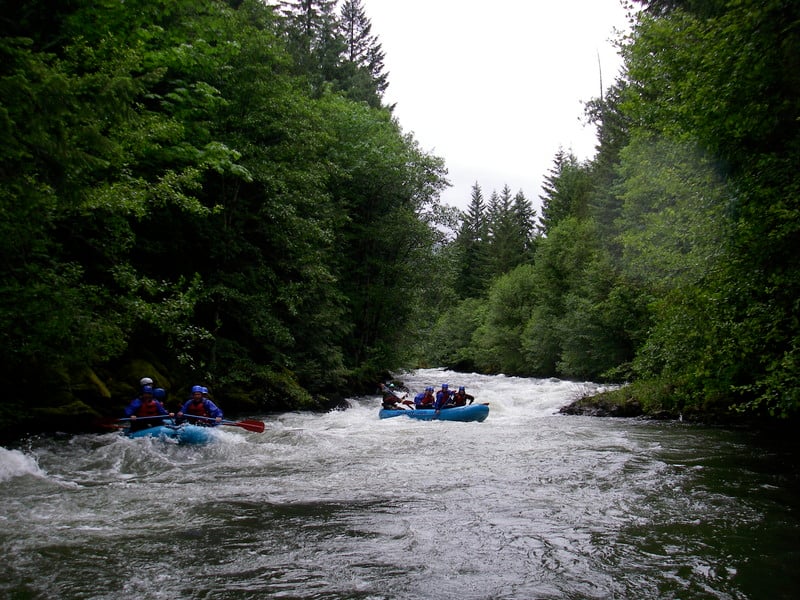
Lower White Salmon, 2.5 miles, Class II
This lower section can be run as a continuation of the middle section but those seeking a good class II training run can start their trip here. The access is on river left just below the second bridge. Immediatlely downstream is Rattlesnake, a good class II/III rapid which at some flows provides a nice park and play spot. The river through this section has approximately two miles of class II rapids including a great surf spot known as Cave Wave. Since Condit Dam was removed in 2011, the class II-II+ rapids continue all the way to the takeout.
The takeout at Northwestern Park on river right is a long gravelled ramp just after a bridge, and requires class II eddy-catching skills. This lower section is a great beginner training run with the hardest rapids at the start. It provides consistent action with several fun but forgiving rapids.
Additional information in: Bennett, J. and T. Bennett. 1997. A guide to the whitewater rivers of Washington, second edition. Swiftwater Publishing. Portland, OR.
Rapids in this Run (14)
Rapid
III+
Top Drop
 Rapid
III+
Rapid
III+
Maytag
 Rapid
III
Rapid
III
Sharks Tooth
 Rapid
III
Rapid
III
Grasshopper
 Rapid
III
Rapid
III
Sidewinder
 Rapid
III
Rapid
III
Corkscrew
 Rapid
III
Rapid
III
Waterspout
 Rapid
III
Rapid
III
Barge Wave
 Rapid
III
Rapid
III
Stairstep Falls
Rapid
Husum Access, Above Falls
Rapid
Hot Launch Access
Rapid
Paddler Staff Gage
Rapid
Husum Access, Below Falls [private]
 Rapid
III
Rapid
III
Rattlesnake
Waterfalls (1)
Difficulty
Class III+(V)
Length
7.5 mi
Gradient
45 ft/mi
Rapids
14
Access Points
Shuttle Info
Follow Hwy. 14 along the Columbia River and at mile 63.6 take Alt Hwy 141 north (this turn is a couple miles to the west of the Hood River bridge across the Columbia). Continue 2.2 miles to the junction with Hwy. 141. It's another 2.0 miles north to the turn-off for the last potential take-out (Hwy. 141 mile 6.7). Here you'll turn west on Northwestern Lake Road and follow it 0.4 miles to a bridge. There is a park with a launch ramp, picnic tables, and a changing area on the downstream river right side of the bridge. Many kayakers also use the take-out upstream at Husum Falls at the bridge across the White Salmon (Hwy. 141 mile 8.8) Parking is available on the upstream river right and downstream river left side of the bridge. To reach the put-in continue north to the Forest Service launch site (acquired from private ownership with the help of the Trust for Public Land) at Hwy. 141 mile 12.8 in the town of BZ (just north of the turn-off for Glenwood Rd.).
Difficulty Classes
I Easy
II Novice
III Intermediate
IV Advanced
V Expert/Extreme
VI Unrunnable
Current Conditions
5-Day Forecast
Whitewater data from
American Whitewater
American Whitewater