4) Hwy 287 Bridge to Missouri R.
Gauge Conditions
Runnable: ? – ? CFS
Approximate reading: This gauge is 0.0 miles away on Dearborn. Use as a general reference only.
Data from American Whitewater & USGS
Run Map
Run Time Estimate
Select put-in and take-out to estimate time.
Plan This Trip
See wind-adjusted speed maps, forecast planning, and detailed time estimates.
Sign in to generate an AI timing estimate for this run.
Whitewater timing varies with scouting, portages, and group pace. Use as a planning baseline.
Description
chris goble shared:
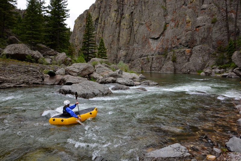
Most of the river is Class I+. The challenge is mainly to keep from hitting the cliff walls that the run goes by. There are 3 rapids that I can remember. The first two are easy II and the last is a shallow boulder garden that runs for a 100m or so before a turn and some medium sized waves. Class II+ or III-. This is one of the prettiest rivers I have seen. There is a small playspot for kayaks about 50m below the put in bridge. The majority of the run is distinguished by the spectacular canyons it goes through. The first canyon is fairly wide open with fairly low walls. Another section has extremely tall cliffsbut is still fairly open. The last section reminds me of a flooded slot canyon in Utah. It is very windy with cliffs extending right into the river.
Rapids in this Run (2)
Difficulty
Class II-III
Length
19.4 mi
Rapids
2
Access Points
Difficulty Classes
I Easy
II Novice
III Intermediate
IV Advanced
V Expert/Extreme
VI Unrunnable
Current Conditions
5-Day Forecast
Whitewater data from
American Whitewater
American Whitewater