4. Mill Creek Falls to Lost Creek Reservoir
Gauge Conditions
Runnable: ? – ? CFS
Approximate reading: This gauge is 1.3 miles away on Rogue. Use as a general reference only.
Data from American Whitewater & USGS
Run Map
Run Time Estimate
Select put-in and take-out to estimate time.
Plan This Trip
See wind-adjusted speed maps, forecast planning, and detailed time estimates.
Sign in to generate an AI timing estimate for this run.
Whitewater timing varies with scouting, portages, and group pace. Use as a planning baseline.
Description
This is a short but great continuous class IV creek-ish run on the upper Rogue River. The first 1.3 miles from Mill Creek Falls to North Fork/Prospect powerhouse is nearly continuous whitewater with many class IV drops connected by class II and III whitewater. Below the powerhouse, the river eases off to class III but the powerhouse adds up to an additional 1,000 cfs. Most paddlers take out at the powerhouse to take advantage of the free shuttle on scheduled release weekends. Continuing downstream to Lost Creek Reservoir increases the total run length to approximately two miles and adds several class III rapids but requires a hike out at the end once you reach the reservoir.
Before embarking on the Mill Creek run, curious paddlers may want to take a look at the stout Avenue of the Boulders section upstream. The best view is from the bridge over the Rogue on Mill Creek Drive. This class V-VI section has been run in parts but is more scenic than paddling material for most. Upstream from the bridge is the class V+ Prospect Falls that was featured in a now-vintage Ashland Mine Productions film. From this scenic view spot it's 0.4 miles down the road to the Mill Creek and Barr Creek Falls trailhead parking area, from which you hike your boat to the water.
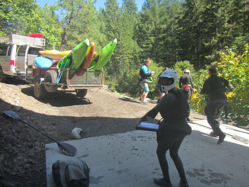
Getting to the put-in is more frightening and strenuous than the river for the experienced creek boater. During PacifiCorp's scheduled recreational flow releases there is a free van shuttle from the powerhouse take-out back to the put-in. Be sure to sign up for the shuttle at the put-in using the the clipboard that's on the picnic table at the southeast corner of the of the parking area. From this spot the hike is all downhill, gentle at first and then ridiculously steep. Take the most direct downhill trail at each intersection. The hike is gentle until the trail drops into the basalt gorge, where you shoulder your boat on the right and down climb a steep trail using handholds on the cliff to your left--or perhaps rope your boat down, as you wish. When you feel the mist from Mill Creek Falls you are almost there. You can split to the right (downstream) to reach the regular put-in, or if you are hungry for more action you can carry your boat upstream to run some of the lower end of the Avenue of the Boulders above Mill Creek Falls (class IV-V or VI if you go too far).
Once on the water the action kicks in immediately. From the standard launch (downstream from the rapid at the base of Mill Creek Falls) there's a class III rapid and then the river disappears over a horizon in a wide boulder garden. First timers will want to go far left and hit eddies down the left side until they either get out to scout the ledge, or see their line from an eddy. This is the steepest short section, and a friendly pool awaits below it.
About 1/4 mile of class III-IV boogie water continues down to the next steeper section, which is the longest boulder garden on the run. At the top a large boulder appears marking the cleanest channel which is to the left of that boulder then back right into the main flow. The action keeps rolling around a long left bend and toward the bottom of the rapid where you encounter three steep waves immediately before the final ledge which forms a stout hydraulic. At the lower release flow (250 cfs) it is boofable but at the 450 cfs flow or more you may want to cut either left or right to go around it. You will find a very short pool below this rapid.
Below this point many class IV drops continue but if you have made it through this first section in one piece you will probably start having a lot of fun. It is read and run (barring new wood) and there are multiple lines through every rapid. Expect to encounter a few sticky holes, lots of boofs, and endless eddy turns. In other words, this is creekin' heaven and if you don't play around in there the 1.3 miles to the powerhouse it will go by way too fast. Many people do multiple laps on the run when the shuttle is operating. A speed run can be done in under 20 minutes on the water.
Locating the take-out point is important. There are actually two powerhouses and you boat past the first one, then take out in a four-boat eddy on river right just upstream from the second one. It's a steep climb on riprap up to a flat spot where the free van shuttle awaits. If, however, it is not an official release weekend there will be no van shuttle waiting and the road is gated so you can't drive in there. You will have to boat down to Skookum Creek and carry your boat up a big hill that requires crossing a short segment of private land to exit the gorge. This is preferable to paddling the reservoir below but few paddle this reach when the shuttle isn't operating.
This reach was dewatered by PacifiCorp's Prospect Hydropower Project though adequate flows still occur during rainy season. During the 2008 FERC relicensing American Whitewater negotiated for the few recreational releases we have now and for real-time flow information and information on scheduled whitewater releases and planned outages (i.e., days when the powerhouse is not operating and the full flow of the river is returned to the natural river channel). The flow in the run is a combination of releases from the dam and from tributaries, notably Mill Creek. Negotiated releases are 250 cfs and 450 cfs, with the lower release occurring one day and the higher one the next. During low water years there may not always be enough available water to make a 450 cfs release.
Logistics
To access the run, take Oregon State Highway 62 to Prospect and turn onto Mill Creek Drive that parallels the highway and takes you through the town of Prospect. The turn onto Mill Creek Drive is at Highway 62 mile 38.5 at the south end of town and mile 45.3 at the north end of town.
Mill Creek Drive has mile markers counting up from south to north and the key locations are as follows:
Mile 1.8, Lost Creek Reservoir take-out: This is the take-out where the North Fork and South Fork join together and end at Lost Creek Reservoir. Here a wire fence with a pull-out for a couple cars marks the start of an old road that has turned to trail. The trail leads down to the reservoir. The trail crosses Skookum Creek which is a good waypoint marking the take-out. This take-out crosses a small piece of private property and permission of the landowner is required. American Whitewater has explored solutions to bring this trail into public ownership and volunteers interested in pursuing this project are encouraged to contact us. Another option is to arrange for a pickup or paddle out on the reservoir.
Mile 4.1, Prospect Powerhouse take-out: This is the turn for the road that leads down to the PacifiCorp powerhouse at river level. In the past paddlers were allowed to drive down the road, but the road is now closed to the public. On release weekends PacifiCorp operates a shuttle service that picks up paddlers at the powerhouse and brings them back up to the put-in at Mill Creek Falls.
Mile 5.3, Mill Creek Falls put-in: The Mill Creek and Barr Creek Falls trailhead is a day use area for those viewing this dramatic waterfall that cascades into the North Fork Rogue River. Hardboaters (or adventurous rafters) will need to follow the rough social trail down into the gorge (bring ropes). Rafts may be easier to get to the water still rolled. Those seeking a stout class V challenge can continue upstream to the 'Avenue of the Giant Boulders.'
Mile 5.8, Mill Creek Drive bridge: This bridge crosses the North Fork Rogue and offers a dramatic view down into the the Prospect Falls.
Rapids in this Run (1)
Difficulty
Class IV
Length
3.3 mi
Gradient
109 ft/mi
max 164
Rapids
1
Access Points
Difficulty Classes
I Easy
II Novice
III Intermediate
IV Advanced
V Expert/Extreme
VI Unrunnable
Current Conditions
5-Day Forecast
Whitewater data from
American Whitewater
American Whitewater