5. FR 9039 to Swift Reservoir (Lower)
Gauge Conditions
Runnable: 700.0 – 3,000.0 CFS
Data from American Whitewater & USGS
Run Map
Run Time Estimate
Select put-in and take-out to estimate time.
Plan This Trip
See wind-adjusted speed maps, forecast planning, and detailed time estimates.
Sign in to generate an AI timing estimate for this run.
Whitewater timing varies with scouting, portages, and group pace. Use as a planning baseline.
Description
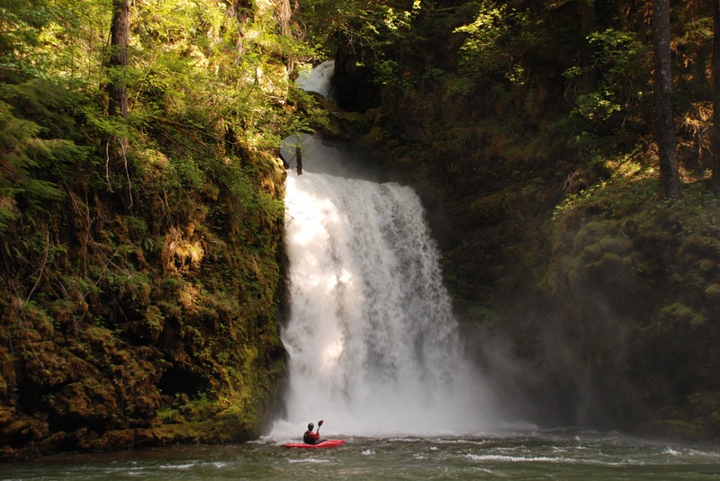
This section of the North Fork Lewis is a beautiful and short scenic run with fairly continuous class II and a couple of rapids that push class III particularly at the higher flows. You can put-in at the FR 9039 bridge where a short scramble on the downstream river right side of the bridge gets you down to the water. You are immediately swept into a beautiful gorge with fun rapids along the weigh and as you round one of the first corners you will be greeted by the spray from Curly Creek Falls. This waterfall is one of the most impressive sites along any river in the region with a double step cascade that flows under a natural rock arch. You can play around in the spray at the base of the falls.
Continuing on downstream there are a couple more falls, seeps, and springs that enter the gorge and maintain a lush native plant community that thrives in the spray zone along the rock walls. About halfway into the run the walls peel back and the river opens up into a broader alluvial valley. There is still plenty of graident and some fun rapids but beware of a few log jams that form along the edges of the river. As you pass Pine Creek which comes in from the right the river descends through one last stretch of nice whitewater as you pass beneath the Eagle Cliffs and the take-out bridge comes into view.
This is a short run but a great option if you are in the area and passing through. With good camping and hiking options in the area it's a great option if you are enjoying a multisports weekend on the Gifford Pinchot National Forest. Some guides describe an alternate put-in at Rush Creek but this road was closed a few years ago. For a longer run you can add on the upstream run and some groups even do this as an overnight trip.
Playspots (1)
Difficulty
Class II-III
Length
3.8 mi
Gradient
26 ft/mi
Rapids
0
Access Points
Shuttle Info
The take-out at Eagle Cliffs is 45 miles from Interstate 5 on Highway 530. The Eagle Cliffs bridge crosses the river at FR 90 mile 15.9 at the head of Swift Reservoir. Easy river access and parking can be found on the upstream river right side of the bridge at a park maintained by PacifiCorp. To reach the put-in continue up FR 90 to mile 20.6 and turn left on FR 9039 and head 0.6 mile down this unpaved road to a bridge across the river and a trailhead downstream river left. This can be done as a bike shuttle or you can likely catch a ride up FR 90 which sees regular traffic particularly on sunny spring weekends.
Difficulty Classes
I Easy
II Novice
III Intermediate
IV Advanced
V Expert/Extreme
VI Unrunnable
Current Conditions
5-Day Forecast
Whitewater data from
American Whitewater
American Whitewater