5. K1 to K2 (Kerckhoff #1 PH to Kerckhoff #2 PH)
Gauge Conditions
Runnable: ? – ? CFS
Approximate reading: This gauge is 3.0 miles away on San Joaquin. Use as a general reference only.
Data from American Whitewater & USGS
CDEC Flow Data California
Data from California Data Exchange Center (CDEC)
Run Map
Description
This short run is just the tail end of the Patterson Bend run, but the K1 parking lot provides a fairly convenient access point. In the past the K1 powerhouse would release up to 1750 cfs during the fall when the Kerchoff #2 powerhouse is shut off for maintanence. However, the K1 powerhouse is old and PG&E has chosen cease generation there. Now, when K2 is down for maintenance any flows in the river will be spilled from Kerchoff Dam at the top of the Patterson Bend Run. Boaters might still choose to do this short run if they have only a little time.
Getting there: From Fresno, take highway 168 into the foothills. Turn left on Auberry Road to the town of Auberry. In Auberry, veer left onto Powerhouse Road at a fork next to the school. From Auberry, follow Powerhouse Rd. just a few miles to a left turn onto Smalley Rd. There should be signs for the "San Joaquin River Gorge Recreation Area" (SJRGRA) which is owned by the BLM. Follow Smalley Rd. to the very end which is the take-out. A gate and some parking areas indicate that you are on top of the underground Kerchoff #2 powerhouse. Walk down the river access trail if you wish to inspect the end of the run. This trail reaches the river near the top of the last rapid.
Put-in: From the take out parking at the end of the road, backtrack 1.5 miles and turn left at a junction. Immediately park at a parking area as the road may be gated just beyond. From here you must carry down to the old powerhouse. Carry around the first gate and follow the road towards some sheds, (1/4 mile). Just before the sheds another gate blocks a narrow road dropping off to the left down to the powerhouse (4/10 mile). From the parking lot at the powerhouse, descend next to the fence, then climb down an awkward 50 feet to the river.
If the gate is open, you can park near the visitor center, then hike down the road to the powerhouse, or park past the visitor center and find a way down the hill upstream of the powerhouse.
Take-out: Drive to the very end of Smalley Rd. and park outside a gate. The transformer station and high tension lines indicate that you are on top of the new underground powerhouse. On the river, paddle a last long class 4ish slalom and eddy out on river left in the channel below the outlets from the underground powerhouse. Carry back upstream and look for a trail heading steeply up the hill.
google map
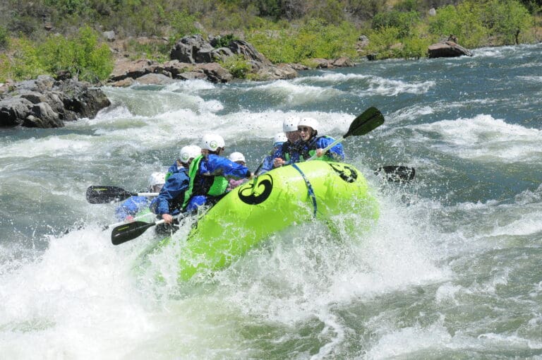
General description: For a warm up at the put-in, paddle upstream past the powerhouse till your path is blocked by boulders. Paddling downstream, pass under a bridge and then enter a fairly long class 2-3ish rapid. The horizon line of a steep class 4, follows immediately. Worth scouting to see the best lines. A nasty hole is at bottom left. A long pool and big boulders follow. Next rapid is a narrow chute on river right. Stay on the tongue. The right side hole and eddy seems to keep boats and swimmers. A long pool leads to the upper falls, a huge boulder blocking the entire channel. Scout or portage on river left. Run a tight creekish route on far right. Scout the lower falls on river right. Portage is very difficult. Run or ski jump a center falls, then run the chute down the left wall. A nasty hole blocks the center and right side at the bottom of the chute. This hole will send you very deep. A long pool allows you to pick up any pieces. (the right chute has been run I think, but looks very ugly and the bottom center boulder is massively undercut on that side.) Several short but interesting class 3 - 4 rapids occupy the remainder of the gorge. The river bends to the left and opens up, then a wonderful long class 4 slalom finishes the run. Boaters can continue down into the Millerton Bottoms run if they are willing to deal with the take-out issues of that section.
The parking area at SJRGRA is about 1,000 feet elevation, with lots of Oaks, grass, brush, and a few pines. There are toilets, picnic tables, and now, even potable water. Camping is free. It is a popular area in fall, winter and spring, for horse back riding, hiking and mt. Biking. Groceries, gas and food are available in Auberry and Prather.
For more information about the SJRGRA see: SJGRA
Information about Millerton Reservoir State Rec Area is available at Millerton SRA
PG&E Kerchoff Project - FERC Relicensing:
The PG&E Kerchoff Project, FERC project No. 96 was last relicensed on Nov. 8, 1979. The license expires on Nov. 30, 2022. The project consists of the small Kerchoff dam &reservoir, and the two powerhouses. The generators at the two powerhouses have a combined rated maximum capacity of 174,075 KiloWatts. PG&E has informed Ferc in 2019 that they will no longer generate power at K1 and will officially decommission it. The building will remain and will be put to other purposes. Search for FERC documents related to Kerchoff at http://elibrary.ferc.gov/idmws/search/fercgensearch.asp In the Docket Number box, write P-96-\* to do a wild card search for any documents related to Project 0096.
The relicensing process typically starts about 4 years ahead of time, so will likely start in 2018. In this process, AW will advocate for scheduled releases from Kerchoff Dam to facilitate whitewater boating in Patterson Bend, K1 to K2 and Millerton Bottoms. We will also advocate for real time flow information below Kerchoff #2 when Millerton is low enough for boating in the Millerton Bottoms section.
Temperance Flat Dam: Temperance Flat Dam Proposal:
This area of the San Joaquin is presently under study for a large dam and reservoir. See: Upper San Joaquin Basin Storage Investigation Three sites were under serious investigation. As of 2014, the final selected site is about one mile upstream of the confluence with Finegold Creek and would have a maximum size of around1.4 million ac/ft. Despite the large size maximum annual yield is around 100,000 ac/ft. This reservoir will bury the Patterson Bend, K1 to K2 and the Millerton Bottoms sections. The study has maps and updates on the proposal.
Draft EIS is out September 2014. Comments are due by October 27, 2014. Send comments to: Melissa Harris
Friends of the River: Dam Facts, Dam Lies, and Statistics
Friends of the River Letter to Governor Schwarzenneger opposing new dams.
Rapids in this Run (8)
Hazards & Portages (2)
Caution: The following locations may require scouting or portaging. Always check current conditions.
Difficulty
Class IV+
Length
1.8 mi
Gradient
55 ft/mi
Rapids
8
2 Hazards
Access Points
Shuttle Info


Difficulty Classes
I Easy
II Novice
III Intermediate
IV Advanced
V Expert/Extreme
VI Unrunnable
Current Conditions
5-Day Forecast
Whitewater data from
American Whitewater
American Whitewater