5 - Northwestern Park to Columbia River Wild
Gauge Conditions
Runnable: 300.0 – 1,500.0 CFS
Data from American Whitewater & USGS
Run Map
Put-in
Take-out
Rapids/Hazards
Wild
Scenic
Run Time Estimate
Select put-in and take-out to estimate time.
Plan This Trip
See wind-adjusted speed maps, forecast planning, and detailed time estimates.
Sign in to generate an AI timing estimate for this run.
Whitewater timing varies with scouting, portages, and group pace. Use as a planning baseline.
Description
With a gradient comparable to sections upstream and a dramatic basalt canyon, paddlers wondered what whitewater treasures were buried beneath the waters held back by Condit Dam. With that in mind and recognizing the opportunity to restore this great river to free-flowing magnificence, American Whitewater formally requested a dam removal study in 1992 and was a party to the 1999 negotiated settlement to remove Condit Dam and drain Northwestern Reservoir. This reservoir buried the river for a century blocking fish migration and innundating a whitewater run. The dam was breached in October 2011and opened to paddlers in November 2012.
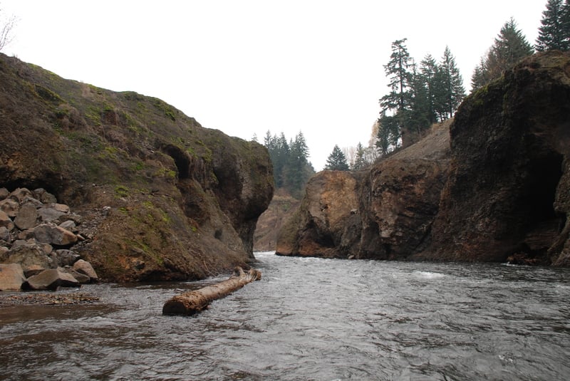
From the put-in at Northwestern Park near the Buck Creek confluence, the river flows through the historic reservoir descending into a basalt canyon. Vertical basalt walls rise on river right as you enter the Lower Gorge with a great series of class III rapids. Constructed fish habitat in the first mile, and naturally deposited wood throughout require that paddlers keep the alert level high for strainers. The former Condit Dam site is easy to miss. Waterfalls cascade in over sheer basalt cliffs making this one of the most beautiful and dramactic sections along the entire river--a section that was hidden from view for over a century below the waters of Northwestern Reservoir. The dam was built in a bedrock notch with a nice pool downstream. It makes a great spot to stop and marvel at the scale of the restoration effort.
The reach downstream of the dam has been paddled prior to removal of the dam. In 1992 American Whitewater volunteers paddled for a study as part of relicensing with PacifiCorp and the National Park Service. This relicensing process eventually resulted in the removal of the dam, and the recovery of significant salmon habitat.
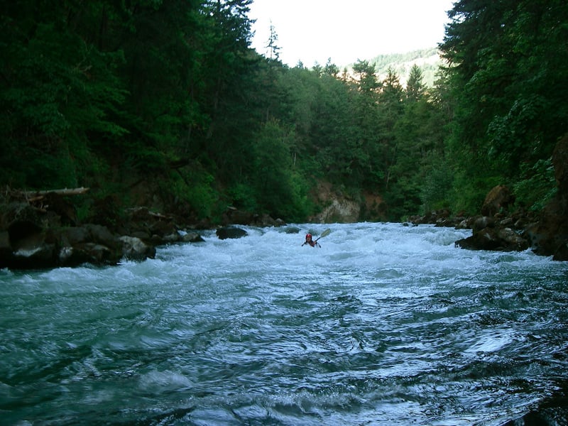
First timers should attempt this run at lower flows (around 2 feet) and work their way up. Summer groundwater flows tend to be steady and cold, making this another ideal run for the dry season in the Pacific Northwest. It is highly recommended to get current information about wood hazards from local regulars. Class IV skills are useful here, as mistake in class III could have significant consequences. Rapids in the gorge sections are difficult to scout due to steep walls.
Leaving Northwestern Park the river is open with a series of class II and then III rapids, some of which are long. Basalt cliffs rise along the right bank, showing bathtub rings from the former lake. When the river begins to gorge up, the whitewater stays class III with occasional pools. The dam site is at the second major constriction in the gorge, and is easy to miss. It is 3.3 miles from here to the Columbia. The gorge continues to deepen.
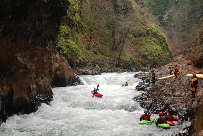
The first mile below the dam site is characterized by fun series of class III rapids with pools at lower flows. Proceed cautiously. A mile or so into the main gorge watch for right bend leading into a stout class III+, and below that a hard bend to the left. This rapid has some big holes at higher flows and can be somewhat sneaked on the left at most levels. Setting safety below it to prevent swims through Steelhead is reasonable. Looking downstream, the right bend leading into this rapid is in the distance.
Stop on river left _before_ the blind left bend, because just around it is Steelhead Falls which is significantly harder and more dangerous than the rest of this run. There are several eddies along the left bank before the bend, but no pool. There is one last eddy on the right at the outside of the bend, but from here one has no choice but to run the drop.
Steelhead Falls marks the entrance to the White Salmon Narrows and is a class IV/V rapid. It is often portaged, and sometimes run, both on the left. The river pours over a ledge creating a beefy hydraulic with a boil pushing to the right. At moderate flows (around 2') route options include a chute down the left side or a boof towards the center. In either case you want to be sure and avoid the hole. As flows increase the drop increases in power and intensity. A little above 3 feet or so on the stick gauge the scout/portage option closes off, and the hole takes on serious proportions.
The portage is a wading scramble along the left cliff, holding on to a rope bolted to the cliff with one hand while floating your boat alongside with the other. When you reach the point where you can see around the blind bend, there is a shelf you can pull your boat up on and finish the portage out of the water. It's the kind of scout/portage that class V creek boaters do on creeks throughout the region, but it can present a challenge for class III paddlers.
There is a nice bedrock bench downstream of the Steelhead Falls on river left that provides a great platform to set safety and take photos. A swim at Steelhead Falls will likely result in getting recirculated in the hydraulic and sucked over to the right wall. A good rope throw from the left shelf can reach a person here. If you are get shoved deep enough by the hole to get out, you are headed for the Narrows and its wood hazards.
Below Steelhead Falls the river flows through the narrowest part of the White Salmon Narrows. In the past wood has collected here and this could be an issue in the future so be sure to get a recent report from locals, especially if there has been a major storm. Below Steelhead the current is fast and eddies are few down to a blind right bend. Around the right bend the water slows and logs do sometimes lodged in the gorge walls.
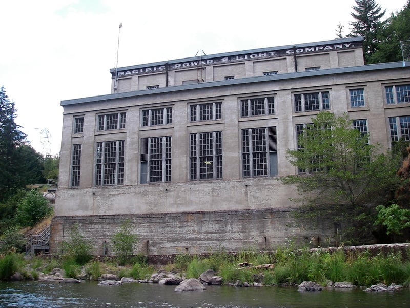
About 1/2 mile below the Narrows you will reach the powerhouse. There is more whitewater downstream, starting out as class II and finishing with a bang with a series of three long III-III+ drops. The last of these is great fun. The river quickly goes flat and you can either hike up the fishermen's trail to Highway 141 (the last one before the bridge is easiest), or continue another 1/2 mile downstream to the Columbia.
Difficulty
Class II-III+(V)
Length
4.9 mi
Gradient
50 ft/mi
Rapids
6
Access Points
Shuttle Info
**Takeout:** Follow Hwy. 14 along the Columbia River and at mile 63.6 there is a bridge across the White Salmon at the confluence with the Columbia providing river access. The public can't use the tribal site on river right but you can scramble up the bank on river left at the Alt Hwy. 141 junction ( [photo](http://www.americanwhitewater.org/content/Photo/detail/photoid/15058/)) to a medium pullout. There is more parking across the highway. Alternatively you can head up the river 1.1 mile from Hwy. 14 to a large pullout ( [photo](http://www.americanwhitewater.org/content/Photo/detail/photoid/15522/)) that provides access via a fishermen's trail that leads down to the river. From the river you can recognize this site by the cable that extends across the river overhead just downstream of the last significant rapid.
**To reach the dam site**, take Alt Hwy. 141 north from Hwy. 14 (just to the east side of the bridge). Continue 2.2 miles to the junction with Hwy. 141. Just past this junction you will see the turn for Powerhouse Road. Follow this road down to the dam where it will make a 90 degree turn to the left to continue downstream. If you look over the edge at this point you will be able to see down into the gorge where Condit Dam once stood.
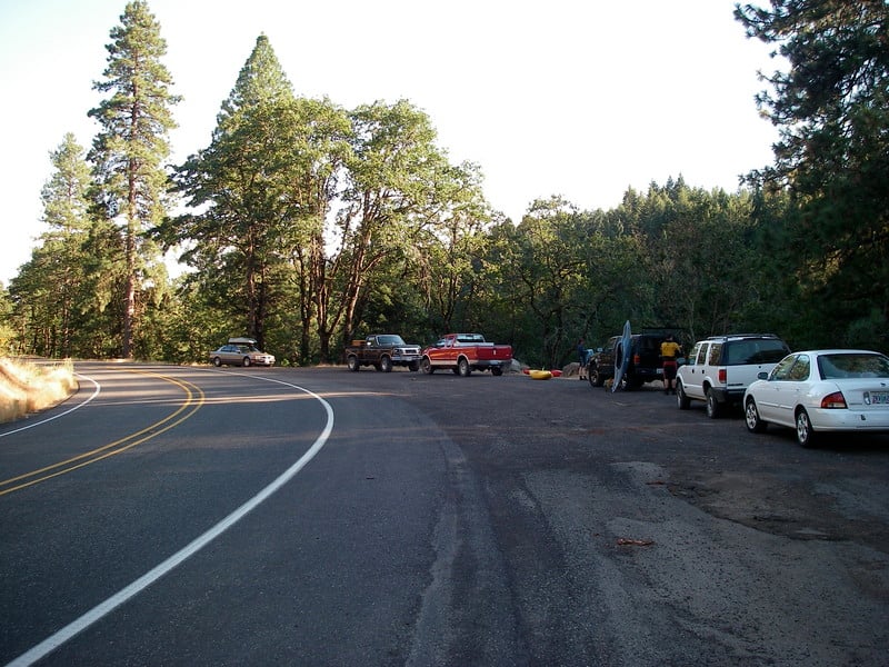
**To reach the put-in**, head 2.0 miles north of the junction between Alt Hwy. 141 and Hwy. 141 and turn onto Northwestern Lake Rd. (Hwy. 141 mile 6.7). Follow it 0.4 miles down to a bridge. There is a park with a launch ramp, picnic tables, and a changing area on the downstream river right side of the bridge.
To make the run longer or to accomodate a variety of paddling skill levels, you can launch above or below Husum falls (see info for river section upstream). This adds 3 miles of mostly class II whitewater and one great surfing wave.
Difficulty Classes
I Easy
II Novice
III Intermediate
IV Advanced
V Expert/Extreme
VI Unrunnable
Current Conditions
5-Day Forecast
Whitewater data from
American Whitewater
American Whitewater