5. Slab Creek Dam to Rock Creek Powerhouse
Gauge Conditions
Runnable: ? – ? CFS
Approximate reading: This gauge is 0.1 miles away on American. Use as a general reference only.
Data from American Whitewater & USGS
CDEC Flow Data California
Data from California Data Exchange Center (CDEC)
Run Map
Run Time Estimate
Select put-in and take-out to estimate time.
Plan This Trip
See wind-adjusted speed maps, forecast planning, and detailed time estimates.
Sign in to generate an AI timing estimate for this run.
Whitewater timing varies with scouting, portages, and group pace. Use as a planning baseline.
Description
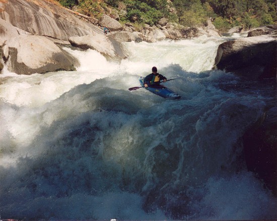
The Slab Creek Run begins with several Class IV+ rapids that are within sight of the put-in. The river has a very continuous nature for the next four miles. Many of the rapids are long and require good Class IV skills. Mosquito Road Bridge at river mile 3.25 provides alternate access options. The most significant rapid on the run, Motherlode Falls (Class V), is not far downstream of the bridge.
The gradient eases after this point and the run becomes Class II/III in nature. There also is more vegetation, primarily alders, in the river channel in the lower section. Rock Creek enters on river right at river mile 5.5. The Rock Creek Powerhouse is the official take-out and is required to provide daily dawn-to-dusk public access; however, the powerhouse owner keeps the gate on the access road locked except during scheduled Slab Creek Run recreation releases.
Put in: From Highway 50 in Placerville, take the Schnell School Road exit and go north to Carson Road until N. Canyon Road. Follow N. Canyon Road to Slab Creek Reservoir road and follow that to a junction near the Slab Creek dam. Two gated roads head downhill. One road leads to the right and to the dam. The other leads to the river a short ways below the dam. Unless we can arrange otherwise, parking will be in the turnouts along the road above the USFS gates. The area by the gates must be kept clear as a turn around. Carry boats 3/10s of a mile down to the river. This will be the site of the future improved put-in.
Take out: IThe Rock Creek Powerhouse take-out located on the north side of the river at mile 5.5. From Highway 193 in Placerville go east 6 miles on Rock Creek Road. The entrance to the powerhouse will be the second road on the right after you cross over Rock Creek. The gate will be open during scheduled recreational releases by SMUD and limited parking is available by the powerhouse. The gate is required to be open daily dawn-to-dusk but the powerhouse owner, Hydroland LLC, ignores this requirement and keeps the access road gate locked at all times other than during scheduled releases. Wlk-in access is always allowed but please DO NOT BLOCK THE GATE.
Mosquito Road Bridge is an alternate take out allows boating the steepest few miles while avoiding Morthelode Falls and the easier water below. Unfortunately there only 3 to 5 parking spaces at this bridge. Make sure the bridge stays clear. There are some parking options further away.
Gage: SMUD is required by a FERC-license stipulation to provide a gage below Slab Creek Dam. The below website has proven to be somewhat more reliable than their dreamflows/CDEC pipeline and can serve as a backup if other gage displays are not reading.
\---------------------------------
From a rafting perspective River Runners President, John Kosakowsky wrote this excerpt from “Slab Creek: The Run That Time Forgot”:
I logged 8 trips on Slab Creek in December and January (some friends of mine rafted it 20 times!). The flows varied between 550 and 1600 cfs. At the low end, we R2ed 10 and 12 foot rafts. You can run all of the holes at low flows and are more worried about big rocks in the way than anything else. It’s a beautiful slalom course and it isn’t very pushy which is nice. At flows around 1000 cfs, a 13’ raft is ideal as there are really powerful drops and holes that want to surf your craft. At 1600 cfs it’s fast and powerful. There are at least 3 river wide ledges that have only one weakness to drive through. The lines are blind at times with the waves crashing high into the air. It starts to feel closer to Class V, and I’m sure the swims would feel at least that serious.
Read the full article on the River Runners website –
\---------------------------------
Jason Bates wrote at boof.com,
Got in their yesterday with a bunch of folks, GREAT time had by all at about 1000cfs (falling slightly during the run). Not sure what other runs to compare to honestly, but of the runs you listed I'd say that at that flow I think Slab is a tad bit easier than Cherry Creek and the South fork of the Salmon. While none of the rapids have moves that are more than class 4 in difficulty (except Motherlode), most rapids do require some strong 'read and run' skills to spot the holes and/or find the tongue or boof to deal with them.
There are a few surprises in there to keep you on your toes, but low to medium flows tend to be fairly open and forgiving while higher flows makes for a lot of very large and grabby holes. Less water things slow down a bit more, and there are more eddies to break things up but the lines get a bit more tight and technical. At moderate flows most class 5 type boaters will likely consider this run more class 4 in nature, while most class 4 boaters will likely find the run just a bit too exciting.
Taking out at Mosquito rd bridge eliminates Motherlode falls (which is a bit of work to sneak/portage). The rapid intensity builds from the bridge to Motherlode, with the last rapid or two above Motherlode being a bit of a step up from anything above the bridge. Other take outs involve more effort, in terms of hiking up out of the canyon or paddling across Chili Bar lake.
Overall I'd say this run is an a real classic: tons of fun challenging rapids, very little wood, very little 'mank' or 'sketch' factor, beautiful canyon, and a nice easy shuttle. It's such a shame that this canyon doesn't have flows more often, but while it does it's quite a nice treat to get to paddle it.
{C}{C}
\-----------------------
Thomas M. wrote ot Boof.com
I think medium flows are between 900-1300. The river starts to get more difficult above 1500 and is much more technical the lower it gets like 600-800
I would rate the run class IV+ overall at medium flows with the exception of mother lode falls V which has a sneak rout on the far left and a semi difficult portage on the right. Another option if you want your shuttle shorter and to avoid portaging mother lode is to take out on river left at Mosquito Ridge rd.
\-----------------------
I did the run today with 1200, last year at ~3000. At optimal flows between 1000-1500 I think the best way to describe it is a notch above Chamberlain's and a notch below 49 to Bridgeport. At that level it is very clean and generally pool drop but every rapid, one right after the next, all the way from put in to (Mosquito) bridge is class IV. At 3000 it's significantly pushier but not really more dangerous (though I'd rate it higher). Lower flows would actually worry me more since it would get quite rocky in a few places.
I highly recommend the take out at the bridge. Motherlode is definitely a bigger rapid than the rest but I didn't think it was all that memorable/worthwhile. And then there's quite a bit of flat water until the long, steep hike out...
There's some video from today on my blog:
*Last edited by bryant\_burkhardt; 06-07-2010 at Boof.com*
\-------------------------------
Other Information Sources:
Upper American River Project main page.
Upper American River Project Schematic.pdf
Chili Bar Reservoir Planning Unit.pdf
Boof.com-SlabCreek
Video-2009-by Bryan Burkhardt
A GUIDE TO THE BEST WHITEWATER IN THE STATE OF CALIFORNIA, HOLBEK & STANLEY, 1998
Rapids in this Run (3)

Difficulty
Class IV-V
Length
6.4 mi
Gradient
89 ft/mi
max 120
Rapids
3
Access Points
Difficulty Classes
I Easy
II Novice
III Intermediate
IV Advanced
V Expert/Extreme
VI Unrunnable
Current Conditions
5-Day Forecast
Whitewater data from
American Whitewater
American Whitewater