5 - Tanner to North Bend Wild
Gauge Conditions
Runnable: 800.0 – 2,500.0 CFS
The gauge is located about 6 miles above the put-in. There are a few large creeks, so during and after rain events, the actual flow can be significantly higher
Data from American Whitewater & USGS
Run Map
Put-in
Take-out
Rapids/Hazards
Wild
Scenic
Run Time Estimate
Select put-in and take-out to estimate time.
Plan This Trip
See wind-adjusted speed maps, forecast planning, and detailed time estimates.
Sign in to generate an AI timing estimate for this run.
Whitewater timing varies with scouting, portages, and group pace. Use as a planning baseline.
Description
SEASON: Winter rains through spring snow melt (typically October to July).
FUN FACT: Popular beginner training stretch used extensively by whitewater classes.
DESCRIPTION:
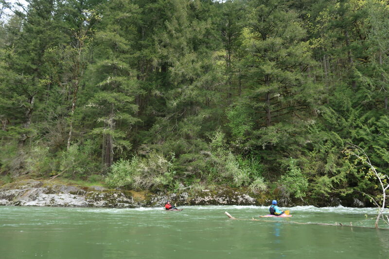
The Club Stretch is an easy class II run with a couple of class II+ rapids. It can be comfortably run as low as 800cfs in kayaks, and can run well into July. The scenery in this section varies between houses and forests. Don't be timid with any of the wavetrains. There are always recovery pools below.
Most of the best whitewater action is in the first mile and there are four good class II gravel bar rapids between the put-in and the Mt. Si Road bridge. This first section is a popular training run often used for instructional programs. Continuing downstream the next signifcant rapid is at Blue Hole which is a headwall drop that has good strong eddylines to practice on.
Many take out at the Blue Hole access. After that, the whitewater tapers off, but the scenery becomes more forested. Those who are out for a day of cruising on the river continue downstream.
A lot of the run is along the base of Mt. Si, and there are several nice views of the mountain, especially near the end. If you continue past the 428th St. Bridge, the river enters King County's Three Forks Natural Area and a paddling trip offers one of the best ways to see this river landscape which includes the confluence with the North Fork and then the South Fork. Be aware of wood hazards. The best public beach access serving as a take-out for this section is just upstream of the Snoqualmie Valley Trail crossing at Meadowbrook Bridge. Between this point and Snoqualmie Falls, the river flows through mostly private land with lots of rip rap making access difficult.
_with contributions by David Elliott_
LOGISTICS:
Tanner Put-in: To get to the put-in take exit 32 off I-90 and go north for 0.6 miles. At the T junction turn right onto North Bend Way and go 0.7 miles. At this point, past the spot where the river runs near the road, turn left onto SE Tanner Road. Take this road down 0.5 miles to the river access parking area. Powerlines crossing the road and leading down to the river mark the access corridor to the river which is along a King County right-of-way. There is a gate across this dirt access road that runs along the powerlines to the river (about a 50 yard hike).
Blue Hole Access: To reach the take-out, head downstream along North Bend Way into the town of North Bend. Turn north on Ballarat Ave. (one block east of the main intersection in town). Continue 0.2 miles and then turn right on Sixth St. Follow this road 0.8 miles to the dead end at the river (you will pass EJ Roberts Park). In the past you could hike downstream along the levee about 100 yards to the the Blue Hole access. Hiking along the levee requires crossing a small sliver of private land--the street end and Blue Hole at the bottom of the rapid are public property and for this reason we recommend only accessing the river at the street end. This was also a popular swimming hole during the summer prior to local property owners raising issues with trespass along the levee where it crosses private land.
Three Forks Natural Area, 428 St. Bridge Access: Another alternative access is downstream at the 428th St. Bridge across the Middle Fork. This access is 2.0 miles from the turnoff onto Ballarat Ave. Just follow Ballarat Ave. which will bend to the right and become SE 108th St. and bend to the left where it becomes 428th. St. Access at the river where the old Norman Bridge crossed the river (it has since been removed) on the upstream river right side of the 428 St. Bridge.
Meadowbrook Bridge, Snoqualmie Valley Trail: An additional access point is another couple miles downstream on river right and is just upstream of the Snoqualmie Valley Trail bridge (the Meadowbrook railroad bridge) at a beach just across from the junction of Reinig Road and 396th Dr. SE.
Rapids in this Run (2)
Difficulty
Class II
Length
6.2 mi
Rapids
2
Access Points
Difficulty Classes
I Easy
II Novice
III Intermediate
IV Advanced
V Expert/Extreme
VI Unrunnable
Current Conditions
5-Day Forecast
Whitewater data from
American Whitewater
American Whitewater