6. Millerton Lake Bottom (Kerchoff #2 PH to Millerton Reservoir)
Gauge Conditions
Runnable: ? – ? CFS
Approximate reading: This gauge is 4.5 miles away on San Joaquin. Use as a general reference only.
Data from American Whitewater & USGS
CDEC Flow Data California
Data from California Data Exchange Center (CDEC)
Run Map
Run Time Estimate
Select put-in and take-out to estimate time.
Plan This Trip
See wind-adjusted speed maps, forecast planning, and detailed time estimates.
Sign in to generate an AI timing estimate for this run.
Whitewater timing varies with scouting, portages, and group pace. Use as a planning baseline.
Description
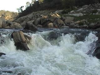
The Millerton Lake Bottom run is a short introduction to the main stem San Joaquin River. It is a good introduction. It has a classic San Joaquin feel with a deep and relatively narrow channel, banks of amazingly sculpted granite and big powerful drops. It is also runnable most years for a few months, typically August, September, October and November, with big flows ranging up to 5,000 cfs. This section of the San Joaquin is usually hidden beneath Millerton reservoir, but each summer the level of the lake gets lower as outflows exceed inflows. By the end of summer up to 3 miles of river can be revealed. Flows are provided into the river from an underground PG&E powerhouse.
The San Joaquin River Gorge Recreation Area (SJRGRA) provides access to the start of the run.
Getting There:
From Fresno, take highway 168 through Prather. Continue east for 2 or 3 miles, then turn left off of highway 168 onto Auberry Road heading north to the town of Auberry. Go through Auberry till the road splits by the school. Veer left onto Powerhouse Rd. After just 2 or 3 more miles turn left onto Smalley Rd and follow it to the SJRGRA.
From the north, take highway 145 from Madera through Friant to Auberry road. Turn left onto Auberry Road and drive east on Auberry Rd to the junction with highway 168 at Prather. Continue on as described above.
Put-in: Once in the San Joaquin River Gorge Recreation Area go all the way to the West end of the road at a gate and park. Carry your boats over the gate and down the road to the water (big switchback), or hike the trail which drops down more directly to the river. As you approach the gate turn right into the lower parking area. The trail starts at the right hand side of this lower parking area. The river elevation is about 220 feet below the parking area.
Take-out: Here is the complication. There is no easy public take out at this time. You have 3 options. 1) Boat as far downstream as you want, then carry your boat back upstream across the lake bottom, or, boat and carry back upstream to the put-in. This option is excellent exercise, but still gets used occasionally. 2) Leave a car at Sky Harbor and 2a) paddle 9 miles across the reservoir. 2b) hitch a ride from a powerboat. 3) Get access down Wellbarn Rd. to Temperence Flat which is 2 miles downstream of the put-in by 3a) going with a local who has access or 3b) calling and writing Millerton State Park (559- 822-2332) and bugging them to allow access for paddlers to use this wonderful little section of river.
Even if you do get vehicle access to Temperence Flat, the driving distance and time between Temperance flat and SJRGRA is ridiculously long. A combination hiking & driving shuttle works best. Drive an empty shuttle vehicle down Wellbarn Road to the take out, while other vehicles with boaters and gear drive to the put-in. The driver of the take-out vehicle then hikes across the lake bottom or along the Millerton trail to the put-in. The take-out driver/hiker will arrive at the put-in within a reasonable time after everyone else. At the end of the run, the drivers of the put-in vehicles hike back across the lake bottom to their vehicles while boats are loaded on the take-out vehicle and driven out.
There is an excellent and popular hiking and riding trail on the south side of the reservoir. It comes close to the reservoir high water mark just downstream of the first rapid. Hiking on the trail is probably easier and faster than in the lake bottom. However there is a fork at a gate in a fence. One fork heads downhill along the fence (going upstream), then traverses near the reservoir high water mark. Finally it climbs up to the powerhouse access road. This lower trail is faster and more direct than the upper trail. The upper trail climbs high above the parking area and eventually ends up at the main junction and camping area 1.5 miles further away. It is easy to miss the small spur trail that drops from the main trail to the parking area at Kerchoff #2.
Elevations:
581' Millerton Reservoir high water mark.
540' Put-in at powerhouse outlet.
520' TurboWave rapid, class 3. Followed by Can Opener rapid, class 3.
500' Temperance Flat rd access. Mile 2 +-
480' Below last class 3 rapid.
470' Lowest possible level of reservoir. Mile 3 +-
Millerton Elevation Level page shows the exact elevation, on the hour and every 15 minutes (type in MIL for the gauge identifier). Notice the hourly fluctuations in the reservoir elevation caused by differences between inflow and outflow. Click on the graphing button at the bottom of the page to more easily see patterns. During late summer and fall, when there are no other significant inflows to Millerton, the graph usually shows an obvious daily fluctuation. Daily rises in the graph indicate when the powerhouse is on, while declines indicate when the powerhouse is off. Longer term rise and fall in the graph indicates whether outflows are larger or smaller than inflows over the longer term.
There should be a delay of several hours between the powerhouse starting up and change in reservoir elevation reading at Friant Dam , 15 miles away. So there is probably flow from the powerhouse at the put-in a few hours before the graph registers an upward change. This will be updated when a more accurate estimate of the time delay can be made.
Millerton website has reservoir elevations, calculated inflows and outflows as well as other information. The actual inflow will be around 20 or 30 cfs while the powerhouse is off and up to 5,000 cfs while the powerhouse is on.
You can get an estimate of actual flows by comparing the daily average inflows with the amount of time the powerhouse is on. Multiply the daily average flow x 24, then divide by the estimated time the powerhouse was actually on. Outflows from the powerhouse often fluctuate a few times during a daily release. You might start off with low flows and end with high flows or vice versa.
Other info: Gasoline, groceries and dining are available at Auberry, Prather and Friant. Velasco's in Prather has excellent mexican food. There is also Thai food in Auberry. Primitive camping is available at SJRGRA and campgrounds have drinking water. There is a small museum and office at the SJRGRA.
Information about Millerton Reservoir State Rec Area is available at Millerton SRA . Check out the recreation area boundaries around the Temperance Flat area by looking at this NE-Millerton-map.pdf
Temperance Flat Dam Proposal:
This area of the San Joaquin is presently under study for several potential large dam and reservoir sites. See: Upper San Joaquin Basin Storage Investigation Three sites were under serious investigation. As of 2014, the final selected site is about one mile upstream of the confluence with Finegold Creek and would have a maximum size of around1.4 million ac/ft. Despite the large size maximum annual yield is less than 100,000 ac/ft. This reservoir will bury the Patterson Bend, Squaw Leap and the Millerton Bottoms sections. The study has maps and updates on the proposal.
Draft EIS is out September 2014.
As of 2018 dam proponants have formed the San Joaquin Valley Water Infrastructure Authority and are working hard to get federal and state taxpayers to fund this project.
PG&E Kerchoff Project - FERC Relicensing:
Flows for this reach come from the PG&E Kerchoff #2 powerhouse. The FERC license for this powerhouse expires in 2022. The relicensing process typically starts about 4 years ahead of time, so will likely start in 2018. In this process, AW will advocate for scheduled releases from Kerchoff Dam to facilitate whitewater boating in Patterson Bend and Squaw Leap. We will also advocate for real time flow information below Kerchoff #2 when Millerton is low enough for boating in the Millerton Bottoms section.
Other Information Sources:
San Joaquin River Gorge Recreation Area
BLM Map of area
Millerton State Recreation Area
NE-Millerton-map.pdf
Friant Dam Statistics
Millerton DailyReport - pdf
Upper San Joaquin Basin Storage Investigation
Difficulty
Class III
Length
3.5 mi
Gradient
20 ft/mi
Rapids
6
Access Points
Difficulty Classes
I Easy
II Novice
III Intermediate
IV Advanced
V Expert/Extreme
VI Unrunnable
Current Conditions
5-Day Forecast
Whitewater data from
American Whitewater
American Whitewater