6. Valley Falls to Hammond
Gauge Conditions
Runnable: 3.7 – 4.7 FT
Data from American Whitewater & USGS
Run Map
Run Time Estimate
Select put-in and take-out to estimate time.
Plan This Trip
See wind-adjusted speed maps, forecast planning, and detailed time estimates.
Sign in to generate an AI timing estimate for this run.
Whitewater timing varies with scouting, portages, and group pace. Use as a planning baseline.
Description
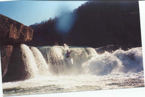
This is a fun run for when not much else is running. Its sometimes called the last water in West Virginia, after everything else has dried up. It's a relatively stress-free way to get some vertical action. It's a shoulder shuttle: park, put-in, paddle, perambulate to previous point of paddling put-in. Due to an agreement between paddlers and park personnel, you have to sign in before running the Falls.
The sign-in area is the superintendent's office, on river right. The putin coordinates given in this website will direct you to the office.
Putin and takeout on river right. Please don't hike back on river left.
If you go as far as Twist And Shout, takeout out under the railroad bridge (39.40187, -80.09554--see the Map tab). Please don't walk back on the active rail line; it's dangerous, and the park superintendent will not be pleased. _(Thanks to Jeff Macklin for this information and for the lat/long coords that should help paddlers stick to river-right boathumpin'.)_
Location: From I-79, take Exit 137, then 310 south for 7 miles. Turn right at the Valley Falls State Park sign. Go two miles to the park entrance. Park at 39.38897, -80.08733.
Paul Herring sez: "The state park named for the Falls is accessed from the river-right side of the US 50 bridge in Grafton by turning on Rt 310, which parallels the Tygart down to the park. The gauge to look for is at Colfax...You want to find the Colfax road for shuttle if running the whole thing, which includes Hamburger Helper and several other wierd rapids but is mostly class I/II the last couple of miles. A rough dirt road runs from downstream along river left, but the park road is much better access."
kdavis wrote, in Boater Talk 2002-08-11(http://boatertalk.com/forum/BoaterTalk/218315):
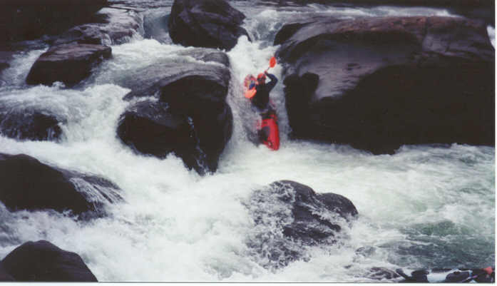
"Thought i was going to drown today. Pretty scary. Second time down through the falls at Valley Falls. dropped the top falls, and went sideways. Side surfed into the curtain. Windowshaded, couldn't roll up. Punched out, and went deep. I guess I got recirced about 4 times, being held down around 30 seconds or so each time. Finally came out far enough past the boil to grab the grab loop on my friend's boat. needless to say, this scared the hell out of me. Iwas completely exhausted after all this. All I know is, I don't wanna go through that again. 'They' say Valley Falls is as safe as it gets for learning, but it still has quite a bite if you f\*up. Got back on the pony and dropped the lower falls. Clean. But it took a while to stop shaking."
Even something with a relatively harmless reputation still has a nasty bite, if you screw up. The top left side has a reputation for spanking the errant paddler pretty hard.
Take this section seriously, especially at high water. This was the scene of a drowning at 6.75 feet (very high) in 2005. Read the accident report here.
There used to be a race here in the late summer. Read I Play Outside's coverage of the 1998 race, with more than your fill of pictures!
Valley Falls State Park
Waterfalls (2)
Playspots (1)
Hazards & Portages (2)
Caution: The following locations may require scouting or portaging. Always check current conditions.
Difficulty
Class II-IV
Length
1.2 mi
Rapids
0
2 Hazards
Access Points
Difficulty Classes
I Easy
II Novice
III Intermediate
IV Advanced
V Expert/Extreme
VI Unrunnable
Current Conditions
5-Day Forecast
Whitewater data from
American Whitewater
American Whitewater