A) Yondota Falls to Copps Mine Rd (1.5 miles) Scenic
Gauge Conditions
Runnable: 150.0 – 300.0 CFS
*Very likely* too low. (Correlation not assured.)
Data from American Whitewater & USGS
Run Map
Put-in
Take-out
Rapids/Hazards
Scenic
Recreational
Run Time Estimate
Select put-in and take-out to estimate time.
Plan This Trip
See wind-adjusted speed maps, forecast planning, and detailed time estimates.
Sign in to generate an AI timing estimate for this run.
Whitewater timing varies with scouting, portages, and group pace. Use as a planning baseline.
Description
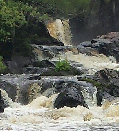
The meat of this short reach is the Yondota Falls sequence, which lies about a quarter mile downstream from the put-in. The Presque Isle tumbles 52' in a third of a mile (~156 FPM _equivalent_ gradient!) through an interesting and varied series of drops. While this reach is located quite a distance upstream of the more popular or well known classic sections of the Presque, the river is still fair sized here and has some power.
Driving to the put-in, the Presque is a calm, meandering river, visible to the right. This soon changes after the river passes beneath the put-in bridge. The current quickens and some light whitewater develops as the river makes a turn to the right. There is a small initial drop and just below, the river constricts considerably next to a river-left rock outcropping and drops away. Get out to scout on the right. There is a 8'-10' vertical falls here that drops into a narrow slot. The hydraulic at the base very powerful and potentially dangerous, backed-up by a spline of rock which splits the already narrow channel below in two. There is a secondary channel to the right which may allow one to bypass the bad hole and drop in downstream at higher flows.
Following this falls, the river spreads out again and enters a series of technical boulderbed ledge drops (3'-5') with only a few eddies in between. Wood collects here but there are generally multiple clean routes. Some of the routes work, and some aren't so pretty, so it may be best to scout the entire sequence beforehand. The run-out from the last of these ledges is the lead-in to the final drop, a bouldery medium-angle cascade of about 12'-15'. Again, there are multiple lines and some may hurt. Below here are some waves and a hole in the run-out. The remaining distance to the listed take-out may hold some lighter whitewater. One could do a shuttle-less run here by simply running to the bottom of the falls sequence and carrying back up the river right trail but it's probably easier to just float down to the listed take-out.
Yondota Falls may be found by turning north off of Hwy 2 in Marenisco on Cty 523 (Copps Mine Rd) and driving north for about 3.25 miles. The shuttle here is simple. From the put-in bridge, continue north following the main road and bearing to the left until reaching the river.
Philippe Damiano reports:
_Andy Lovering, Erik Strahler, and Chris Arnold ran this section at 1.24ft. The falls was the highlight, but the rest of the section was good. Desperate paddlers might find refuge running laps on this section if everything else is too low._
Note: There is about 16 miles of low gradient river from this (listed take-out of this upper section) to the next listed section of this river (Underwood Tower Rd to Steigers Bridge).
Rapids in this Run (2)
Difficulty
Class IV(V)
Length
1.5 mi
Gradient
60 ft/mi
max 73
Rapids
2
Access Points
Difficulty Classes
I Easy
II Novice
III Intermediate
IV Advanced
V Expert/Extreme
VI Unrunnable
Current Conditions
5-Day Forecast
Whitewater data from
American Whitewater
American Whitewater