Arctic Valley Rd. put-in to bridge
Gauge Conditions
Runnable: 4.6 – 5.5 FT
Data from American Whitewater & USGS
Run Map
Run Time Estimate
Select put-in and take-out to estimate time.
Plan This Trip
See wind-adjusted speed maps, forecast planning, and detailed time estimates.
Sign in to generate an AI timing estimate for this run.
Whitewater timing varies with scouting, portages, and group pace. Use as a planning baseline.
Description
Access Issue on Ship Creek: This creek passes through Joint Base Elmendorf-Richardson. While this military base allows recreational access for multiple outdoor activities (hiking, biking, skiing, and hunting) under specific guidelines through the iSportsman online system, whitewater boating on Ship Creek is specifically prohibited. This closure has been actively enforced since a local paddler was cited for trespassing in 2009.
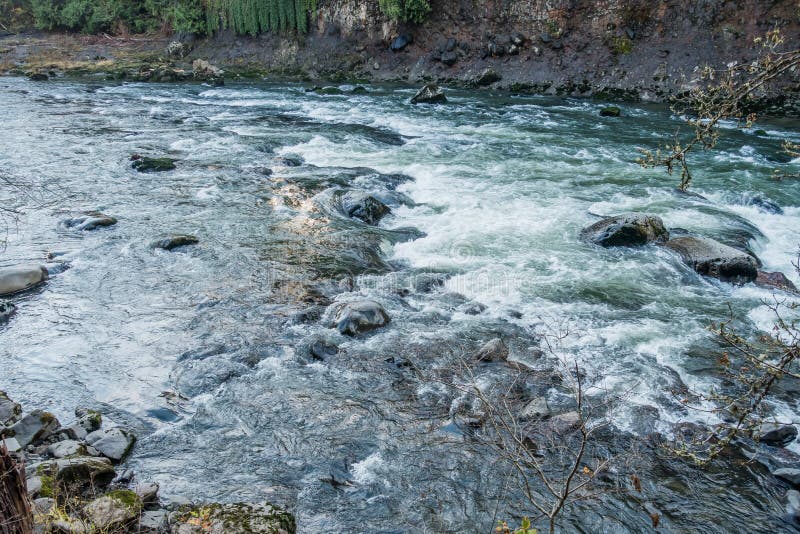
Ship Creek is a beautiful, crystal clear, steep, relatively warm stream flowing out of the Chugach Mountains and only 5 minutes outside of Anchorage. The scenery and whitewater are top notch on this highly technical creek. A creekboat is recommended but experienced packrrafters can also enjoy this run.
The run starts out with class II warm-up and little boulder gardens. After about 1 mile it starts to pick up and transitions to class III/IV with several large boulder-garden drops. Stay alert for wood hazards that may require a portage. The run continues about 2.5 miles to the Canyon. Just before the Canyon the creek makes a sharp left turn and twists back to the right. The run transitions from a big open valley to creek contained within tight gorge walls. The Canyon itself is 1.25 miles long and is class IV. It is no wider than 10' in some areas. The very beginning and very end of the canyon have a class IV rapid. Stay left all the way down the first 100 yards on the first rapid. At the waterfall at the end stay towards the left side and boof--it will be a slight left-hand angle (right-hand stroke). Be prepared to possibly slam into a pillow against a rock on your left.
Directly after running the waterfall, take out at a gravel road on river right to portage around a dam that is not runnable. Hike up the gravel road for 5 minutes until the road makes a right-hand turn. From this point local paddlers had a trail with hand lines down to the base of the dam that was established before access was restricted and the closure was enforced. This portage takes approximately 15-20 minutes. A second weir structure just downstream of the main dam also requires a portage (takes 2 minutes) as it is very dangerously undercut with nails and rebar.
Continue paddling down through class II to the take-out bridge (about 0.5 miles).
The entire run takes approximately 5 hours to set shuttle, get geared up, hike-in, run it, portage, and load up.
Logistics:
Put-in: Take Glenn Highway northeast out of Anchorage to mile 7.8 until you see Arctic Valley Road on your right. Exit and stay straight. You will pass the Moose Run Golf Course and go through a few open gates until the road turns to dirt. Continue up mountain, a total of 5.9 miles from the highway, until you see the Artic Valley Ski Area come into view (look for chairlifts). Turn off on big gravel pull-out on right and park. You will see the Ship Creek Valley Trail blocked from motor-vehicle access that leads down to the creek/valley. Make sure to bring a strap to drag your boat. Hike down trail about 30 minutes until you can see the creek about 100 yards away. Cut across a small wetland feature to access the creek. The trail is mostly downhill but watch out for moose and bears.
Take-out: take Glenn Highway out of Anchorage for about 5 minutes until you see Arctic Valley Road on your right. Exit and stay straight. You will pass the Moose Run Golf Course then stay alert for a sign that says Snowbird Cabins (or some kind of cabins sign) on your right. Take that road until you get to the bridge that crosses Ship Creek on the connector between Arctic Valley Road and Oil Well Road. Park in the gravel turnaround; this is the best take-out option.
Hazards & Portages (1)
Caution: The following locations may require scouting or portaging. Always check current conditions.
Difficulty
Class IV
Length
4.6 mi
Gradient
155 ft/mi
max 165
Rapids
0
1 Hazard
Access Points
Difficulty Classes
I Easy
II Novice
III Intermediate
IV Advanced
V Expert/Extreme
VI Unrunnable
Current Conditions
5-Day Forecast
Whitewater data from
American Whitewater
American Whitewater