How's Your
River
×
Explore
Explore Map
Water Bodies
Gauges
Access Sites
Tidal Stations
Whitewater
Pricing
Login
Sign Up
Whitewater
Wisconsin
Potato - B) Foster Falls (Sullivan Rd) to Hwy.169 (7.5 miles)
Whitewater Run
WI
Class II-IV
B) Foster Falls (Sullivan Rd) to Hwy.169 (7.5 miles)
Potato
Linked via:
Proximity
96% confidence
Synced 5mo ago
Pin Location
Monitor
Water Body
Map
Rapids (10)
Gauge
Weather
Put-in
Gauge Conditions
Potato River near Upson, WI
Upstream
Primary
Runnable: ? – ? CFS
Approximate reading:
This gauge is 0.0 miles away on Potato. Use as a general reference only.
Data from
American Whitewater
&
USGS
Run Map
Radar
Counties
Cell
Verizon
AT&T
T-Mobile
Dark
Satellite
Terrain
Description
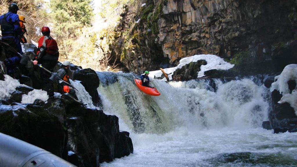
Higher grade rapids are in first 1.5 miles from Foster Falls, most of which can be done as an extension of the prior reach and then exit the river. The following video show runs of Foster Falls: _
https://youtu.be/ZsB-zJ\_1nAc
_
Rapids in this Run (10)
Rapid
USGS sampling site
0.0 mi
Rapid
Foster Falls
0.1 mi
Rapid
Dells
0.3 mi
Rapid
Falls?
0.8 mi
Rapid
Rapids?
3.0 mi
Rapid
Minor Rapids?
3.3 mi
Rapid
Braided Channel
3.4 mi
Rapid
LARGE Island
3.7 mi
Rapid
Island
5.0 mi
Rapid
Confluence: Lawrence Creek
5.7 mi
Difficulty
Class II-IV
Length
7.3 mi
Gradient
34 ft/mi
max 106
Rapids
10
Access Points
Put-in
46.4208, -90.4597
Take-out
46.4619, -90.5080
Difficulty Classes
I Easy
II Novice
III Intermediate
IV Advanced
V Expert/Extreme
VI Unrunnable
Current Conditions
5-Day Forecast
Whitewater data from
American Whitewater
B) Foster Falls (Sullivan Rd) to Hwy.169 (7.5 miles)