B) Upper: near Arvon quarry to Quartzite Falls (2.5 miles)
Gauge Conditions
Runnable: 8.6 – 9.9 FT
Data from American Whitewater & USGS
Run Map
Run Time Estimate
Select put-in and take-out to estimate time.
Plan This Trip
See wind-adjusted speed maps, forecast planning, and detailed time estimates.
Sign in to generate an AI timing estimate for this run.
Whitewater timing varies with scouting, portages, and group pace. Use as a planning baseline.
Description
This run (when coupled with the lower Slate) is considered by some boaters to be some of the U.P.'s finest spring boating. It has excellent backwoods scenery, a real small creek feel, and a bunch of great drops.
For early season runs, snow or mud are likely to preclude travel on the logging road beyond the quarry. If the road is passable, there is gradient upstream (to the listed put-in) which could add to the length and enjoyment of this otherwise fairly short segment. Otherwise (quite often) drive is as far up the road as one can travel with your various shuttle vehicles, and slog your way to the river.
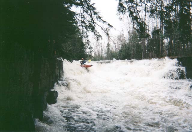
On this upper run, the river is quite a small stream, mostly meandering through the woods. Random bedrock intrusions create an assortment of drops, most of which are boat-scoutable at reasonable water levels. The main exception is the final drop, Quartzite Falls, which comes just downstream of a bridge. Scouting is recommended from the right bank. A very irregular ledge drops the boater onto a low-angle slide (grungy at lower water levels) feeding into a hole as the water hits a pool at the end of the slide. With enough water to make the slide not-grungy, the hole can get rather meaty.
Take-out after running this drop and carry back upstream to bridge, or (if owner's permission is obtained in advance) proceed downstream to take-out at "Heartbreak Hotel" (a cabin just downstream, and immediately adjacent to both the river and Arvon Road).
This reach is likely to be combined with the lower run, but ~2.2 miles between the sections (as we have them listed) is flatwater punctuated by plenty of deadfall. It's a tough call whether its more hassle to 'double-shuttle' or suffer the flatwater and snags. The lower run is completely different in character, and a serious notch up in difficulty and potential consequence. Hardcore boaters may wish to completely skip the upper to concentrate on the lower run. It should be noted that it also contains a flat stretch with an even worse problem of deadfall.


Difficulty
Class II-III+
Length
2.2 mi
Gradient
90 ft/mi
max 126
Rapids
9
Access Points
Difficulty Classes
I Easy
II Novice
III Intermediate
IV Advanced
V Expert/Extreme
VI Unrunnable
Current Conditions
5-Day Forecast
Whitewater data from
American Whitewater
American Whitewater