Baker's Crossing to Rough Canyon Marina (47 miles)
Gauge Conditions
Runnable: ? – ? CFS
Approximate reading: This gauge is 0.3 miles away on Devils. Use as a general reference only.
Data from American Whitewater & USGS
Run Map
Run Time Estimate
Select put-in and take-out to estimate time.
Plan This Trip
See wind-adjusted speed maps, forecast planning, and detailed time estimates.
Sign in to generate an AI timing estimate for this run.
Whitewater timing varies with scouting, portages, and group pace. Use as a planning baseline.
Description
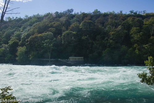
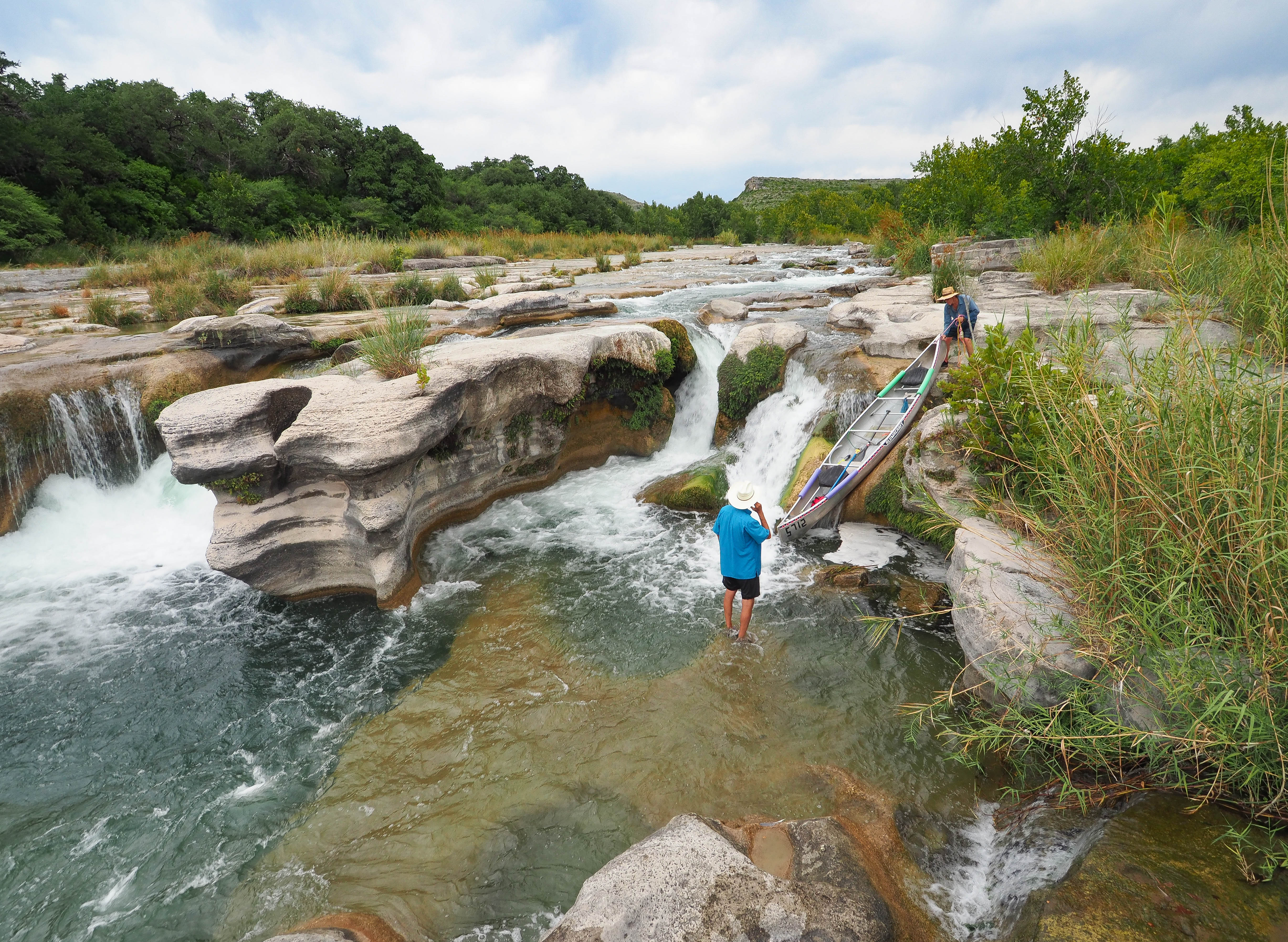
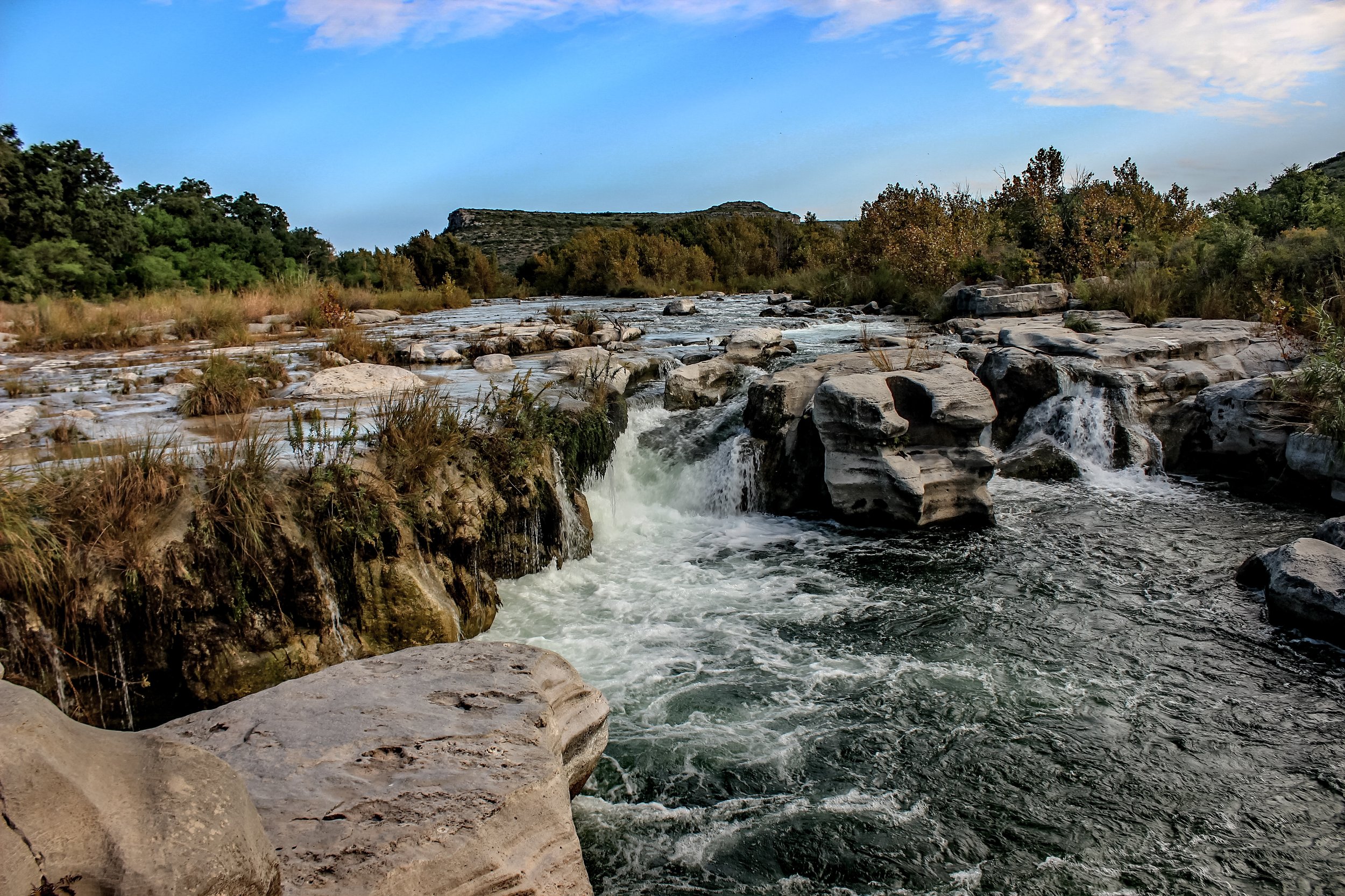
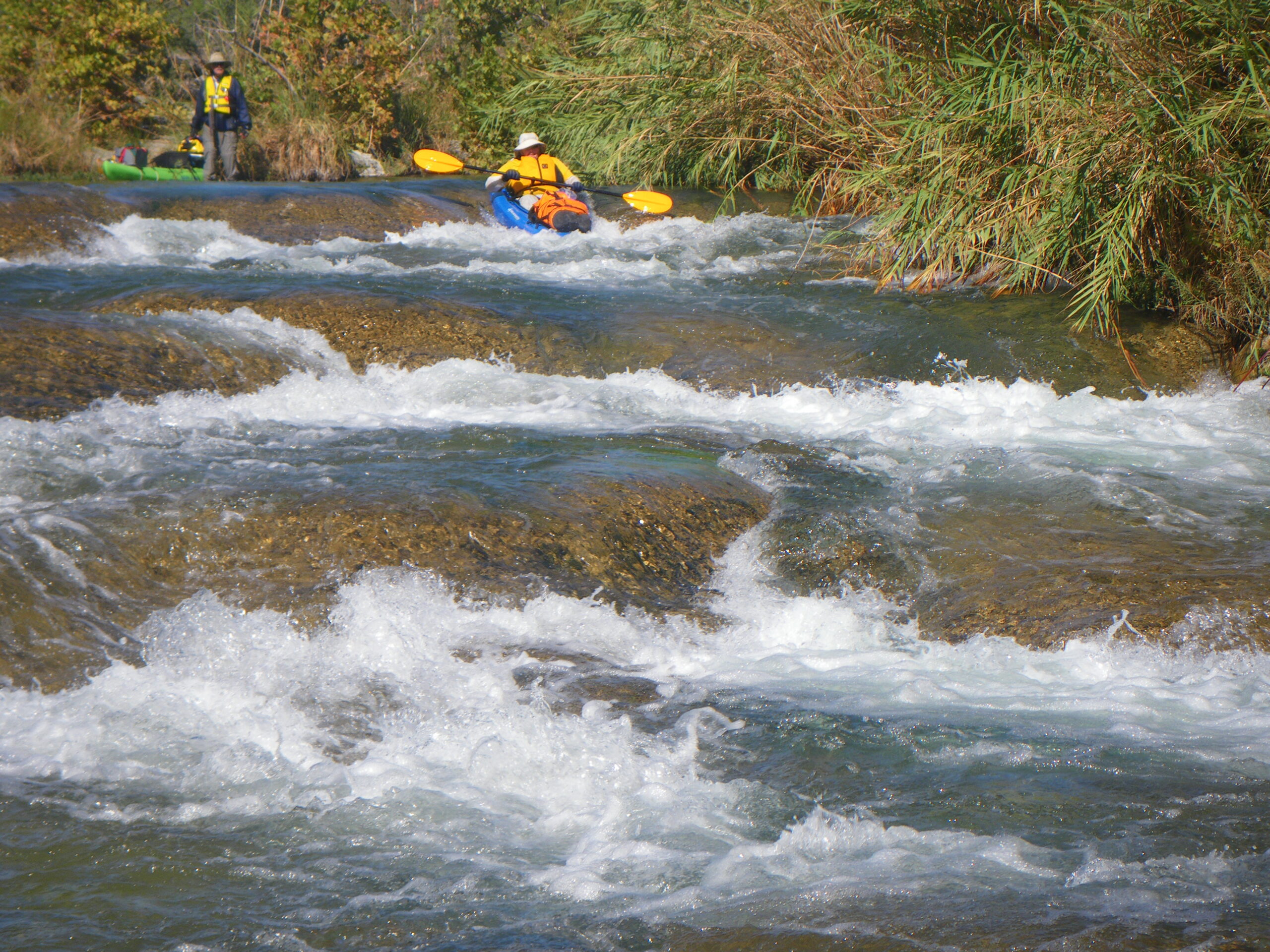
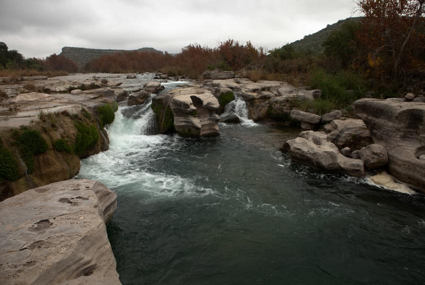
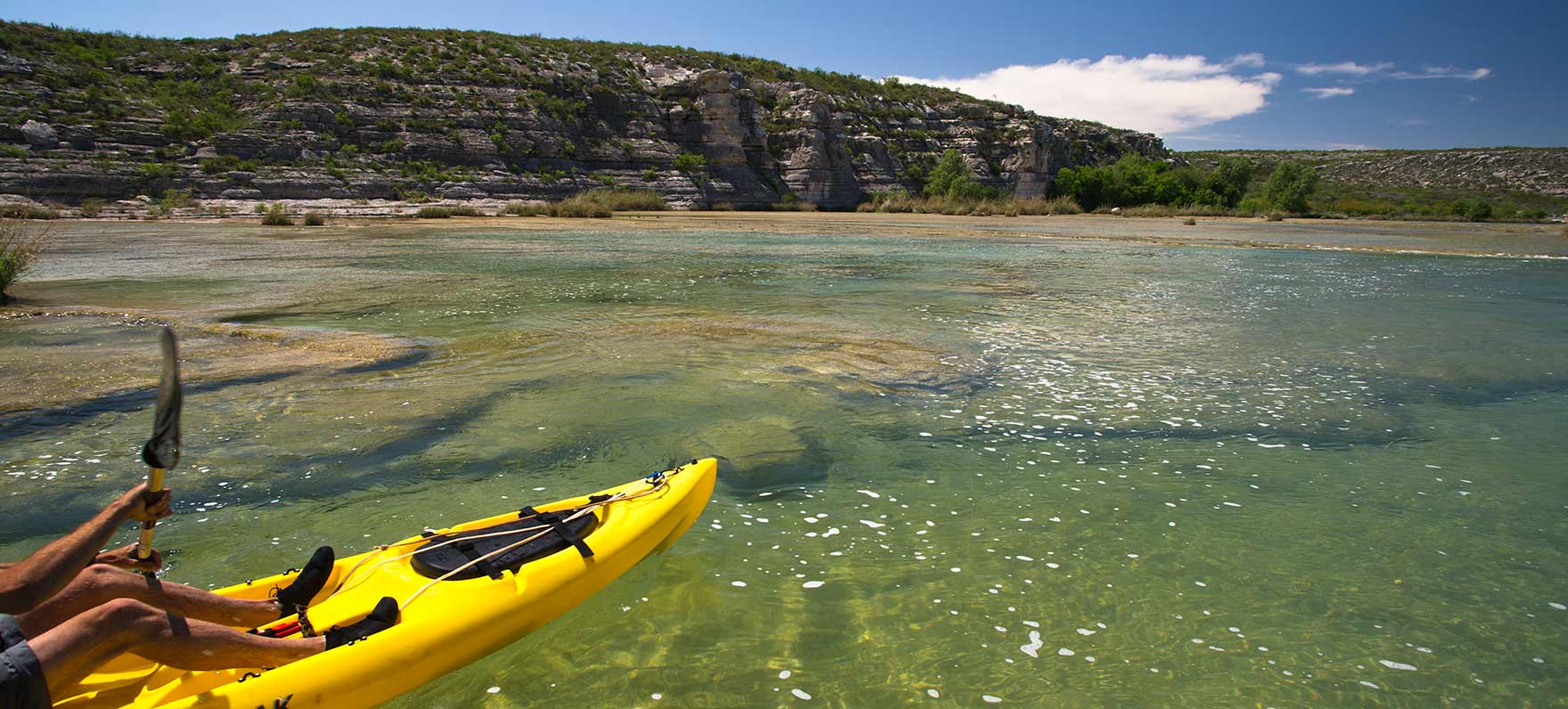
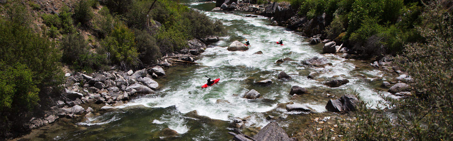
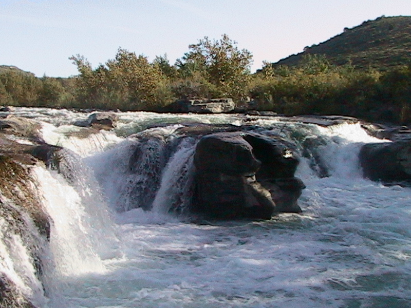
The Devils River is a true desert oasis. Bounded on all sides by arid scrubland, the river's constant spring-fed base flow creates a unique riparian ecosystem with numerous cottonwoods and other large trees, water as clear as a coral reef, and abundant fish and wildlife. The geology of the Devils is unusual, even for Texas. Numerous uplifted limestone slabs create artificial dams, so essentially the river takes the form of a series of long lakes separated by short rapids. The rapids are frequently braided into narrow channels separated by dense vegetation. The physical character of the river thus bears more resemblance to a mountain stream than it does to a typical Texas river. The high calcium content in the water (which is responsible for its clarity), as well as the relatively low flow, has caused accretion of a travertine-like substance on all of the rocks in the shallow areas of the river (i.e. the rapids.) This substance is extremely grippy and rough and makes it impossible to run many of the rapids at low flow. It also puts a great deal of wear & tear on boats. With the exception of the four named rapids (Sycamore Chute, Dolan Falls, Three-Tier, and Dandridge Falls), the rest of the rapids are Class I-II and are often separated by miles of flat water with frequent headwinds. Thus, many choose to paddle the Devils in recreational boats rather than whitewater gear. The appeal of the Devils is mostly its scenic beauty, crystal-clear water, and the experience of overnighting in one of the most remote areas in Texas.
As with many scenic rivers in Texas, the Devils has numerous access issues. TPWD owns two large sections of land, one at approximately Mile 15 (from Baker's Crossing) and another at approximately Mile 30. These are called, respectively, the Del Norte and Dan A. Hughes (formerly Big Satan) Units of the Devils River State Natural Area. Unfortunately, however, as of this writing, only authorized outfitters/guides (concessionaires) are allowed to access the river at these locations. If you want to run a private trip, your only choices at this time are:
1. Paddle all 47 miles from Baker's Crossing to Rough Canyon Marina.
2. Paddle from Baker's Crossing into Lake Amistad and arrange a motorboat shuttle to carry you the rest of the way to Rough Canyon Marina.
3. Pay hundreds of dollars for one of the authorized outfitters to run the shuttle for you (one outfitter quoted nearly $700 to shuttle the upper and middle sections, or nearly $500 to shuttle just the middle section, regardless of group size.)
4. Paddle from Baker's Crossing to Blue Sage (Mile 23) and pay Gerald Bailey's Devils River Outfitters (830-395-2266) or Who Cares B&B (830-703-9210) to run shuttle for you, but of course this cuts out 7 of the best miles of the river. Rumor has it that Gerald can also be contracted to run a motorboat shuttle for you in Lake Amistad, but this is not confirmed. As of this writing, Who Cares B&B charges $80/person to shuttle to Baker's Crossing, which will be cheaper for small groups than paying a state park concessionaire.
Running the entire 47 miles from Baker's to Lake Amistad is strenuous and logistically difficult, due to the scarcity of public campsites and access points. There are paddlers' camps in both units of the Devils River SNA, and paddlers can, for a nominal fee, obtain a permit to camp in these sites. However, because the campsites only hold a handful of people, permits are limited. Plan well in advance if you want to camp in these official campsites. Otherwise, if you cannot obtain a permit for your chosen days, then your only other choice is to camp in the riverbed or on islands in the stream (nowhere in between.) Choose your campsites wisely along this river, as the ranchers in the area do not take trespassing lightly. There are reports of paddlers being harassed by landowners, even when the paddlers were camping below the gradient boundary. If you choose to camp in the riverbed or on an island, pay close attention to the weather. Flash floods along this river are rare, but they do occur.
For the most part, the landowners along the Devils would prefer that you not be there. Encounters with them are rarely friendly. They seem to believe that the Spanish land grants that gave the land to their ancestors supercede current Texas navigability law. This is such a pervasive myth that even the local law enforcement will regurgitate that talking point, and/or they will try to convince you that there is a special exemption in the law for the Devils River. There is not. In fact, the Spanish land grants ended at the riverbank (reference: Handbook of Texas.) It was a 1929 law (the Small Act) that granted ownership of the riverbed to landowners who owned both banks. However, referring to this article from a TPWD lawyer, "\[E\]ven if a landowner's deed includes the bed of a navigable stream, and taxes are being paid on the bed, the public retains its right to use it as a navigable stream ... \[T\]he general public has the right to walk within the boundaries of any navigable streambed, even if there are private ownership rights under the Small Bill." As with other Texas navigability disputes, being on the right side of the law does you no good when you are staring down the barrel of a landowner's rifle-- particularly when the sheriff agrees with said landowner. The rangers in the state natural area seem to take a more balanced tone, but even they will tell you (incorrectly) that the gradient boundary is a constant 11" above the water line (since the water line is flow-dependent, this obviously can't be true. Refer to the aforementioned TPWD article for the accepted legal definition of the gradient boundary, the definition that is applied to every other navigable stream in Texas.) In general, neither the landowners nor the local law enforcement recognizes the right to portage on the Devils. In short, you may be hassled if you access the riverbank or riverbed adjacent to private property, even if you are clearly within the legal definition of the gradient boundary. When choosing unofficial campsites, your best bet is to camp on one of the islands adjacent to the state natural areas.
The Devils is a leave-no-trace area, so if you plan to camp, you will need to haul out all of your waste (including human waste, unless you are camping at one of the official paddlers' camps, both of which have composting toilets.) Please respect this unique and pristine ecosystem. Please do not trespass. Through your actions, you are not only helping to preserve this beautiful river, but you are also demonstrating to landowners that paddlers are good river stewards.
The Devils can generally be divided into three sections:
1. Upper: Baker's Crossing to Del Norte Unit of Devils River SNA (15 miles)
2. Middle: Del Norte Unit of Devils River SNA to Dan A. Hughes Unit of Devils River SNA (15 miles)
3. Lower: Dan A. Hughes Unit of Devils River SNA to Rough Canyon Marina (17 miles)
1\. Upper: Baker's Crossing to Del Norte Unit of Devils River SNA
This section mostly consists of the aforementioned long lakes and short rapids, with Sycamore Chute being the only rapid of any consequence. This section is doable at about 2.3' on the Baker's Crossing gauge, but at that level, it will require a lot of butt scooting and/or creative line choices and/or dragging boats down the more shallow rapids. 2.8' or above is recommended. The average gradient of this section is 11 fpm.
2\. Middle: Del Norte Unit of Devils River SNA to Dan A. Hughes Unit of Devils River SNA
Starting at about Mile 14 from Baker's Crossing, the river picks up additional flow from numerous springs and from Dolan Creek. This section is therefore runnable at lower levels than the upper section is. It is known to be fully or almost fully runnable at 2.3' on the Baker's Crossing gauge. The average gradient on this section is less than that of the upper section (5.5' as opposed to 11'), but the rapids tend to be steeper. Three of the four named rapids (Dolan Falls, Three-Tier, and Dandridge Falls) are all along this section of river. While this is the most popular section, running it without running the other sections requires (as of this writing) paying a guide/outfitter many hundreds of dollars for a shuttle between the two units of the state natural area.
3\. Lower: Dan A. Hughes Unit of Devils River SNA to Rough Canyon Marina
When Lake Amistad is at full pool (1117'), the Devils will run out into the lake somewhere near Pafford Crossing (between Mile 33 and Mile 34.) When the lake is low, however, then an additional 4-5 miles of rapids can appear. For the most part, the rapids along this stretch of river are extremely wide and extremely shallow, often punctuated by a maze of narrow, slightly deeper channels ("wagon wheel ruts".) Unlike the upper section, the pools between the rapids on this section are small or non-existent. When they exist, they are often shallow and contain numerous shoals. At 2.3' on the Baker's and Pafford Crossing gauges, the rapids on this section are known to be mostly unrunnable. Some can almost be run by carefully picking lines through the maze of deeper channels, but often these channels will peter out before the crux of the rapid, requiring boaters to get out and walk. 3' or above on the Pafford Crossing gauge is recommended. Hiring a motorboat shuttle to carry you from the end of the river to Rough Canyon Marina is strongly recommended.
TPWD provides a planning guide for Devils River trips, which contains additional beta. Southwest Paddler also provides additional beta, although it tends to overstate the difficulty of rapids (Dolan Falls is not a V+.) Texas Whitewater provides additional beta regarding the behavior of the river at higher flows.
Distances and gradient measured using GIS tools in 2015.
Rapids in this Run (14)
 Rapid
Rapid
Miller Island
 Rapid
II+
Rapid
II+
Sycamore Chute (Game Warden Rock)
 Rapid
Rapid
Del Norte Island
 Rapid
Rapid
San Pedro Point Paddler Camp
 Rapid
Rapid
Dolan Creek Confluence
 Rapid
II+
Rapid
II+
Three-Tier Falls (The Cascades)
 Rapid
Rapid
Devils River Outfitters
 Rapid
II
Rapid
II
Dandridge Falls
 Rapid
Rapid
29-Mile Paddler Camp
 Rapid
Rapid
Big Satan Islands
 Rapid
Rapid
Amistad National Recreation Area Boundary
 Rapid
Rapid
Pafford Crossing
 Rapid
Rapid
Pafford Crossing Weir
 Rapid
Rapid
Big Satan Creek Confluence
Waterfalls (1)
Hazards & Portages (3)
Caution: The following locations may require scouting or portaging. Always check current conditions.
Difficulty
Class I-II+(IV)
Length
47.2 mi
Gradient
8 ft/mi
Rapids
14
2 Hazards
1 Portage
Access Points
Difficulty Classes
I Easy
II Novice
III Intermediate
IV Advanced
V Expert/Extreme
VI Unrunnable
Current Conditions
5-Day Forecast
Whitewater data from
American Whitewater
American Whitewater