C) Apple River Falls (0.55 mile)
No sufficiently local live gauge linked. 1 automated match was excluded because the closest is 138.4 miles away. Difficulty and route details are not current water conditions.
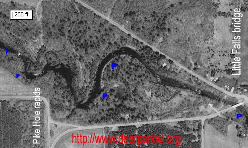
Run Map
Run Time Estimate
Select put-in and take-out to estimate time.
Plan This Trip
See wind-adjusted speed maps, forecast planning, and detailed time estimates.
Sign in to generate an AI timing estimate for this run.
Whitewater timing varies with scouting, portages, and group pace. Use as a planning baseline.
Description
A few miles downstream of the popular 'tubing' stretch of the Apple River in Somerset) the river enters a backwater from a dam. Most of the flow (most of the year) will be diverted through a penstock into a power plant for hydropower generation. When flow exceeds capacity of the penstock and generation demand, water may be allowed in the normally bypassed reach.
At least one good ledge (and it appears there may be more) could create some whitewater interest. We have no specific awareness of any runs of this reach. Anyone having more boater-specific info is encouraged to help your fellow boaters out by providing a comment or report! Are there more ledges? Or is this it?
Rapids in this Run (1)
Playspots (1)
Difficulty
Class II-III
Length
0.5 mi
Gradient
60 ft/mi
Rapids
1
Access Points
Shuttle Info
Since this is a fairly short reach (just about a half-mile) if/when it is boated, it will most generally be a park-and-play, walking the obvious 'shuttle' back to your vehicle. Howwever, you can use the text-entry box below to get drive time, distance, and directions from your home or other starting location.
Difficulty Classes
I Easy
II Novice
III Intermediate
IV Advanced
V Expert/Extreme
VI Unrunnable
Current Conditions
5-Day Forecast
Whitewater data from
American Whitewater
American Whitewater