Chicken Coop Gap to East Cowpen Road - Upper
Gauge Conditions
Runnable: 300.0 – 2,000.0 CFS
Upper limit for best boatability uncertain. Please help your fellow boaters with a comment or report.
Data from American Whitewater & USGS
Run Map
Run Time Estimate
Select put-in and take-out to estimate time.
Plan This Trip
See wind-adjusted speed maps, forecast planning, and detailed time estimates.
Sign in to generate an AI timing estimate for this run.
Whitewater timing varies with scouting, portages, and group pace. Use as a planning baseline.
Description
Northern Georgia Canoeing, Sehlinger, B. and Otey, D.
Appalachian Whitewater: The Southern States
Put In for Upper Consauaga: Finding the put-in is the hard part. From the take-out drive up West Cowpen Road to Chicken Coop Gap. For lack of a better description, go about four miles up West Cowpen, then look for a turnout on the left. You should be able to just barely see the river at the bottom of the hill if there are no leaves on the trees some 250 vertical feet below.
From there carefully carry your boat (or lower it on a short leash) down a shale and mud covered steep incline (borderline cliff) to the river.
Gradient by mile: 91, 56, 56, 128, 66, 40 ft/mi. .
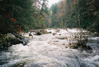
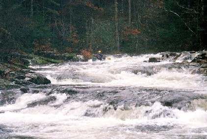
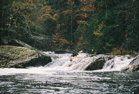
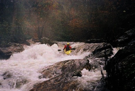
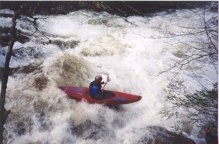
The first few miles after the Chicken Coop Gap put-in offer a nice warm-up leading up to the major rapids. The four big drops, all located in that steep (128 ft/mi) fourth mile, are IIIs and IVs. The most difficult are Undercut (aka Room of Doom) and Whale Tail. They will be obvious, especially Whale Tail with its impressive roostertail of water.
Keep an eye out for wood in all of the major drops. Another thing to watch out for is rebar in the drops. About 100 years ago this area was extensively logged and the rebar is leftover from the logging.
The Upper Conasauga is a beautiful wilderness run. People have put on higher than Chicken Coop Gap and report that it is a great run, though it does require quite a bit of work to get to the river.
*Directions to the Upper Upper put-in from Boatertalk:*
*'I don't remember the exact mileage, but from the take-out. Go back in the direction that you came in, take the first left up a steep hill. At the fork stay right, when the road T's, go left. This will dead end @ a trail head. It is probably a 20 minute hike downhill to the creek. Total driving distance is probably 8-10 miles. There is section below the put-in with class III - IV fun, it's all read & run same as the lower part. Hope that this helps.'*
Directions: From Atlanta take I-75 north to Highway 411 north. Continue north on Hwy 411 thru Chatsworth, Ga. to Cisco. In Cisco look for the Cisco Baptist Church. It's a stone church on the east side of the road at the intersection of Hwy 411 and Old Ga. Hwy 2, which turns into East Cowpen Road. Go east on East Cowpen Road into the Cohutta wilderness for about 7 miles.
Take Out for the Upper Conasauga: The Conasauga take-out is NO LONGER the first major stream on the right as you come thru the mountains and the Alaculsy Valley opens up. Take out at the Old Hwy 2 Bridge to avoid landowner issues and make sure to park on the USFS land downstream side of the bridge, not on private property on the upstream side.
On the way to the take-out you will pass a game checking station. The game checking station is where West Cowpen Road intersects with East Cowpen Road. Using a good topo-map, a compass, and a GPS, you should be able to find Chicken Coop Gap on West Cowpen Road.
*From Boatertalk (Nov 27 2001):*
*'If you get on GA Hwy 2 east follow it all the way until you get to Hwy 411 intersection...there will be a gas station on your right and a church kind of in front of you and to the left...you are now in Cisco...drive straight across the intersection and go exactly 3.2 miles...you will see a guard station on your left....the take-out with the crooked tree is down the road past the guard station...just a little ways after the little wooden bridge (look for small creek on river left)....from the guard station go up the road to your right exactly 5.8 miles to the put-in...listen for water...there will be a 4-wheeler type trail behind you on the left and a sign that says no motor vehicles....then bring your rope because you are going down a steep freakin put-in....go straight down(don't go to right when trail looks like it goes that way)...don't carry your boat...bring a rope.... water is straight down there....Yes, I call that one undercut rapid(room of doom)....and Yeah Whale Tail is good to go... use gauge at Eaton, GA for Conasauga....but it drops fast and sometimes by the time that water gets to that gauge, it's already gone from the gorge....if the water table is up and we get a good rain, then get there early for a good level.*
*peace,*
*Jamie Smith'*
Difficulty
Class III-IV
Length
7.4 mi
Gradient
80 ft/mi
max 180
Rapids
6
Access Points
Difficulty Classes
I Easy
II Novice
III Intermediate
IV Advanced
V Expert/Extreme
VI Unrunnable
Current Conditions
5-Day Forecast
Whitewater data from
American Whitewater
American Whitewater