Confluence with Teanaway River to Thorp
Gauge Conditions
Runnable: 1,000.0 – 15,000.0 CFS
Flow range for best boatability uncertain. Please help your fellow boaters with a comment or report.
Data from American Whitewater & USGS
Run Map
Run Time Estimate
Select put-in and take-out to estimate time.
Plan This Trip
See wind-adjusted speed maps, forecast planning, and detailed time estimates.
Sign in to generate an AI timing estimate for this run.
Whitewater timing varies with scouting, portages, and group pace. Use as a planning baseline.
Description
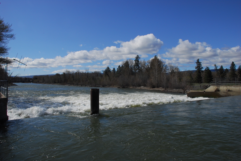
With a consistent release from upstream reservoirs supplying irrigation demand this is a good float through the summer. Be aware of wood hazards and avoid the irrigation weir that forms a dangerous hydraulic (either take-out upstream or make a plan to portage).
A standard run is from the Teanaway confluence down to the Thorp Highway Bridge. For a longer run you can put-in further upstream on the Cle Elum River at Bullfrog Road just before it joins the Yakima River.
ACCESS: The put-in at the Teanaway confluence is a WDFW site (Discover Pass required). At Highway 970 mile 2.5 (just west of the junction of Highway 970 and Highway 10) turn south on a dirt road following the signs for river access across the railroad tracks and continuing about a 1/4 mile down to the river. An alternate access about a mile downstream is avialable where Highway 10 crosses the Teanaway River at mile 89.3. This is an informal access with a short carry down to the water and roadside parking.
To reach the take-out from the put-in, head back out to Highway 970, turn right, and in 0.1 mile turn on to Highway 10. Follow it 9 miles to Highway 10 mile marker 97.3 where you turn right on Thorp Highway. Continue 0.9 mile down Thorp Highway to the bridge across the river. Access is available on the downstream river right side of the bridge.
An alternative take-out is available a little further downstream at Highway 10 mile marker 101.1. This is just upstream of the lowhead dam that must be avoided (it has been the site of a couple fatalities) at Highway 10 mile marker 101.5.
Rapids in this Run (2)
Hazards & Portages (1)
Caution: The following locations may require scouting or portaging. Always check current conditions.
Difficulty
Class II
Length
16.0 mi
Gradient
14 ft/mi
Rapids
2
1 Hazard
Access Points
Difficulty Classes
I Easy
II Novice
III Intermediate
IV Advanced
V Expert/Extreme
VI Unrunnable
Current Conditions
5-Day Forecast
Whitewater data from
American Whitewater
American Whitewater