County Rd 200s to 150s (1.75 miles)
No sufficiently local live gauge linked. 1 automated match was excluded because the closest is 45.6 miles away. Difficulty and route details are not current water conditions.
Run Map
Description
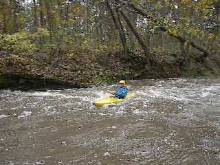
This is a small creek with some small rapids (mostly class 1+ except at high water) and having a rock bottom and rock banks. The current is fast all the way so if you don't stop to play it is a short fast run. At low to medium levels this is a good beginner stream, having some small waves to surf, eddies to catch, and a few rocks to dodge. At high flows it gets pushy with nice-sized waves and eddies along the banks, however at such flows one must watch out for trees. The creek runs through a woods which is public property.
This makes a good warm up for the bigger rapids on the Wabash and, quite conveniently, has the same take out. (If you have three vehicles, each of which can handle all boats and boaters, you could meet at take-out, leaving two vehicles, drive one vehicle up to put-in for this run, boat down, load into a second vehicle and drive to put-in for the Wabash, boat down, then load into final vehicle to drive and retrieve the other two shuttle vehicles!)
Rapids in this Run (1)
Playspots (1)
Difficulty
Class I-II
Length
1.7 mi
Gradient
18 ft/mi
max 24
Rapids
1
Access Points
Shuttle Info
**Put in.** Take the Markle exit (224) off I-69 and go East, turn right on 116 and go to 4-way stop turn right on HY 3 and go south, the third road is County RD 200 S turn right and put in at the first bridge. Park on the right side of the road before you cross the bridge.
**Take out.** Go north on HY-3 to County RD 150 S and turn left, go to the end of this road and you will come to the Wabash, Rock Creek comes in just to the left.
Difficulty Classes
I Easy
II Novice
III Intermediate
IV Advanced
V Expert/Extreme
VI Unrunnable
Current Conditions
5-Day Forecast
Whitewater data from
American Whitewater
American Whitewater