CR 409 to Guntersville Lake
Gauge Conditions
Runnable: ? – ? CFS
Approximate reading: This gauge is 12.1 miles away on Short Creek. Use as a general reference only.
Data from American Whitewater & USGS
Run Map
Description
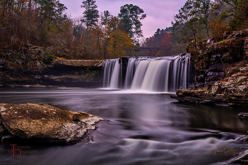
'This is a very nice though short section of Sand Mountian action. The falls at the put-in is a classic and the action continues unabated to the lake. As Short and Scarham combine just above the lake to make on last rapid one has to wonder what was covered up by the lake.' - Will Thornton
Short Creek is an excellent intermediate creek run, sporting a squeaky-clean 18-foot waterfall, a thick stack of quality rapids, and relatively straightforward (but strenuous) access logistics. Though there is a 3 mile lake paddle, and the water quality is poor (definitive 3 chickens, by the AL WW standard), this reach deserves consideration any weekend there's local water.
Short runs relatively frequently, nearly as often as Town Creek. Thanks to StreamBeam, an online gauge exists so you can check the levels before you head out! It can be found at the link below:
http://www.streambeam.net/Home/Gauge?siteID=1
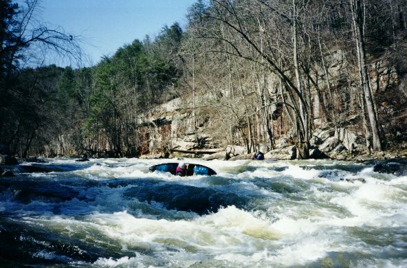
The online gauge updates several times per hour, and correlates almost perfectly with the old stick gauge on the AL 75 bridge. Look for upwards of 0.5' for minimum flow, and above of 1' for good water. Above 2', holes become significantly stickier, and the boil at the base of the falls is particularly ominous. Runs down to 4-5'' on the old bridge gauge have been done without too much hassle, though at that point it's a test of your tolerance for rocks.
The listed address for the put in is approximate – look for a bridge over the creek with a gravel pull off on the river left, downstream side. It is tempting to park at the Hustleville Road bridge to cut off the warmup rapids, but the county has put up no parking signs on both sides of the bridge. If the water is high and you want a more interesting warmup, Drum Creek is a tributary which enters just above the falls and offers some nice class III water. See Alabama Whitewater for a description. The takeout is simple, park at the ranger station on AL 227 near the boat ramp.
Rapids in this Run (5)
Waterfalls (2)
Hazards & Portages (1)
Caution: The following locations may require scouting or portaging. Always check current conditions.
Difficulty
Class III-IV
Length
8.2 mi
Gradient
77 ft/mi
max 90
Rapids
5
1 Hazard
Access Points
Shuttle Info
The takeout is at the Ranger Station on AL 227. Make sure you leave the big spaces near the ramp for trucks with trailers, as fishermen love this spot too.
Put-in is on Martling Road (CR 409). Park in a gravel area on the river left, downstream side of the bridge.
Google Maps should be able to guide you between the two locations.
Difficulty Classes
I Easy
II Novice
III Intermediate
IV Advanced
V Expert/Extreme
VI Unrunnable
Current Conditions
5-Day Forecast
Whitewater data from
American Whitewater
American Whitewater