Fall Creek Falls State Park to Highway 30
No sufficiently local live gauge linked. 1 automated match was excluded because locality could not be verified. Difficulty and route details are not current water conditions.
Run Map
Description
Fall Creek Falls State Park.
Put in: Park your vehicles at the visitor center above Cane Creek Falls.
The walk to the put in trail is easy to find. Leaving the visitor center walk uphill to the stop sign. Hang a left and walk downhill untill you pass a small bridge. Right after the bridge there will be a sign indicationg Cable trail. It is reccomended you belay or lower your boats down the cable trail by rope.
Wear your helmet, sticky rubber shoes, rope / partner assist required half way down - it is a very steep trail!!!
Take Out: Hwy 30 bridge at 285 jct.
Gauge information: Calfkiller gauge correletion may the ticket, but look for Great Falls Dam 'inflow' 4000 - 7000 ( check inflow by clicking http://www.tva.gov/lakes/gfh\_r.htm )
Use the Calfkiller as a signal if it is running or not, but due to caves make sure there's enough water to paddle at Highway 30 bridge. C heck red gauge at putin or takeout before you put on
Gauging information was passed from Clay Wright and Bankfull1 from Boatertalk as Follows:
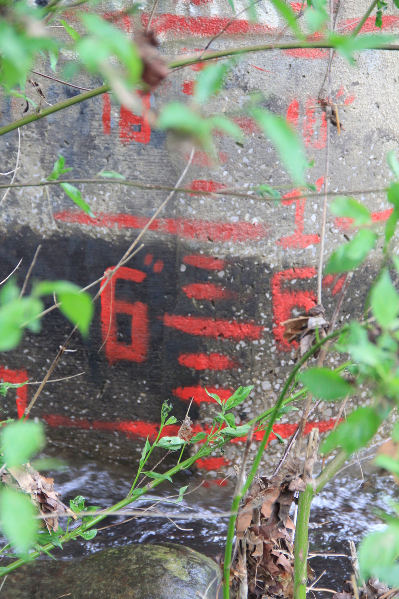
Red Put-in gauge: Is on the cement 'diving area' on the little mini-lake above a dam upstream of the falls below a swinging bridge.
'-2'' would be 2'' below my personal 'not really jonezing' minimum and at 0 you don't have to walk.'
Levels were closely matched to the Red gauge at the take out when painted.
Red Take-out gauge: Under Hwy 30 Bridge on the pillar closest to river right. It is on the bottom of the pillar in the bottom righthand corner. Gravel moves so much the minimum changes often - most important is if you can paddle the last rapids easily, you can likely run the rest.
-2' Is the Lowest I've run. The flat water paddle out was slow and and we wheel-chaired the far right channel around the islands where the river splits, but the gorge was plenty fun. The OC1 shot is likely at that level.
0' is low
6' is medium
1' is high
above 1' is getting big
Fallin Down shots were at 3 old or 1.5 on the new Red gauge . . .hold on!
Blue Take-out Gauge: Under Hwy 30 Bridge on the pillar in the middle of the bridge.
The lower blue gauge changes too much to be reliable at low flows - at one point 1' was runnable, then recent years it read 2' even in summer because there was a pool formed by a gravel bed just downstream of the bridge. So a red gauge was put on the near bridge piling downstream of where the gravel bed is so it reads more consistently. If you must use the blue gauge:
2' is the minimum
2.5' is a good medium
3' is getting huge
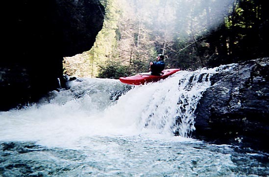
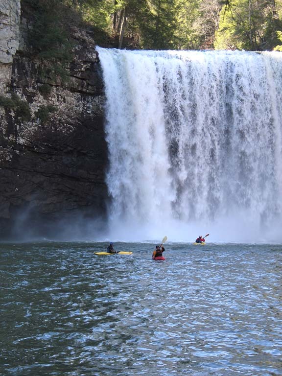
River Information: Paddle up at put-in for best view of 80'+er in TN
Rapids include:
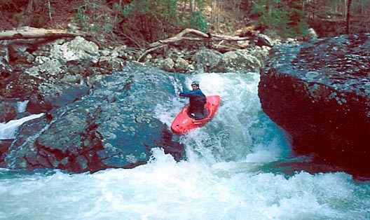
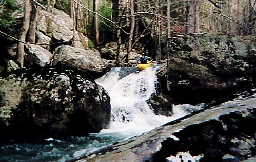
Pine Tree Falls,
Crack slot - a long fun section leads to a blind drop..ride left slab rock of crack.. scout for wood first
Twin Towers (this hole flanked by huge rocks the site of many disasters),
Corner Pocket (hole on left can get sticky),
Airplane turn - watch the left rock and possible wood below
Hallway Falls, has less water now.. nasty crack opened in center line.
Rear Entry (now snuck left) - is back in business on right at come flows, but the bottom sieve right is a factor.
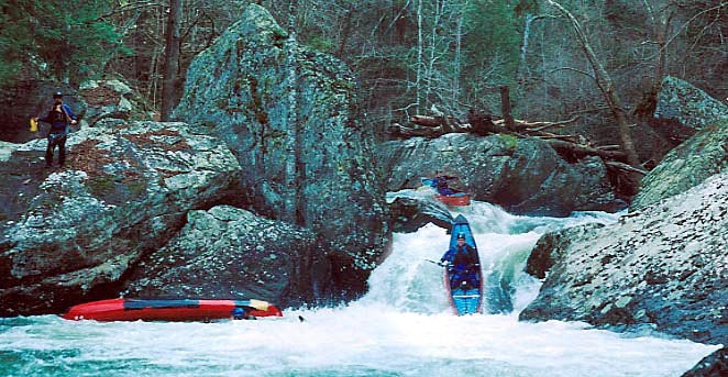
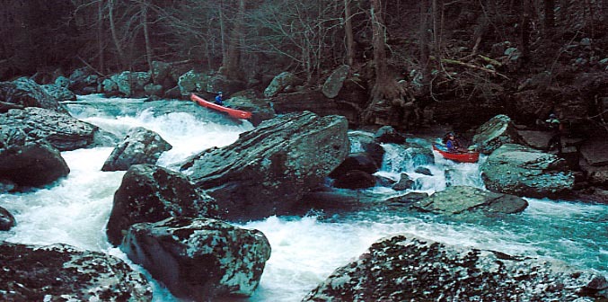
Miles of class 2-3 then 1-2 follow, can be scrapy, always long. Count on an hour paddling after swinging bridge.
When the river splits 4 ways, pick Right channel - still brushy / rocky up top but deep water below.
Watch for logs!!!
Daniel Talley adds Wrom: PNKMBIPBAR
Thursday night it had rained a dab, only around an inch in these parts and not quite enough to get stuff goin to par. Richland Creek was running, but I wanted something new. Being disappointed in the situation, I strapped the boat on top of the car and headed west to Fall Creek Falls. For years I've been wanting to run Cane Creek, and being a semi-large watershed I figured it would have some water. It did, not much but enough was there for some sunny November fun.
From the falls to the confluence of Fall Creek was a blast. Several IV+ made for some good fun, and I'm sure at higher levels class V would not be an overstatement for some of them. It had some of the best boulder garden drops I've seen, constant s-turns back to back with great climaxes at the end.
After Fall Creek, it flattened out for a good 3/4 mile with an occassional class III. Then I came upon around three or four excellent drops, you know, those that have three or four slots to choose from, and only one of them not having a sieve with a tree in it. The trees were pretty bad in this 1 mile stretch, having to get out two or three times.
The rest of the run I just sat back, enjoying the scenery on many many class-II shoal rapids. All was well, aside from the overwhelming feeling that I was running out of water. I thought to myself, surely I haven't outrun the water, as I crossed through several large pools, almost mini-lakes.
Suddenly, I couldn't quite see the exit to the pool. Luckly I found a small exit, but yes, I was running out of water. The next thing I know, the water becomes very silty with an aqua color and I run this little wave train straight into a cliff. The cliff has three or four vertical slots where the water was entering. Over to the right was a 6-ft whirlpool, nothing violent, but interesting nonetheless. Getting next to the cliff, the air pressure made for an interesting sound.
Over to the left was the dry riverbed that I walked for 100 yards or so and luckily found a road that eventually led to hwy 30. 45 minutes later a nice nursery owner took me back to my car.
Interesting day. Maybe next time I'll wait until later in the season when that cave fills up and I can paddle happily to the bridge.
Anyone else had similar experiences with this run or nearby watersheds? and two, is there a gauge in the park?
-daniel
Clay Wright helped out with:
Paddle behind falls at low levels - no, haven't run em - many have - but behind the falls is seriously undercut and windy.
Logs plague this run, but several class 4 and 5 rapids in virgin forest canyon. Watch for 'Twin Towers' - named for the World Trade Center similarities. Was for the 2 big rocks flanking the drop. Now for the Big f\*&$in hole. Set rope river right.
3 mile paddle out through scrapey-scenic class 1-2. Under 0'', much flow disappears.
Rapids in this Run (8)

Waterfalls (1)
Difficulty
Class IV-V
Length
7.0 mi
Gradient
94 ft/mi
max 252
Rapids
8
Access Points
Difficulty Classes
I Easy
II Novice
III Intermediate
IV Advanced
V Expert/Extreme
VI Unrunnable
Current Conditions
5-Day Forecast
Whitewater data from
American Whitewater
American Whitewater