Franconia to Ammonoosuc
Gauge Conditions
Runnable: 3.1 – 3.5 FT
Based on user comments
Data from American Whitewater & USGS
Run Map
Run Time Estimate
Select put-in and take-out to estimate time.
Plan This Trip
See wind-adjusted speed maps, forecast planning, and detailed time estimates.
Sign in to generate an AI timing estimate for this run.
Whitewater timing varies with scouting, portages, and group pace. Use as a planning baseline.
Description
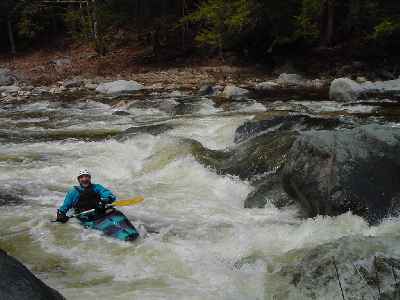
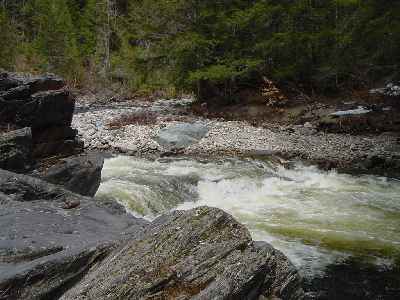
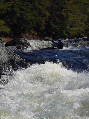
The Gale is a beautiful northern NH river. The river starts out class II and picks up in intensity as a boater heads downstream. The first mile is class II, the second mile is class II-III, the last mile is the class IV gorge section. The last mile is the toughest as the river cuts a deep narrow gorge through an old basalt lava dike. The change in geology is responsible for the ledgy nature of the gorge section. The gorge contains several class IV ledge drops.
### Technical info
```
Put in elevation........850'
Take out elevation......650'
Total drop..............200'
1st mile................50'
2nd mile................60'
3rd mile................90'
Average drop/mile.......67'
Distance................3.0 miles
River width average.....70'
River geology...........Medium to large granite boulders,
basalt schists ledge at the gorge
River water quality.....excellent, clarity good.
Scenery.................excellent northern spruce/fir forest scenery,
river is wild and isolated.
Wildlife................Deer, hawks, moose, merganzers, coyotes.
```
## Directions
### Put in
Interstate 93 to exit 38 (Franconia).
Left at the end of the ramp towards Franconia.
Right on NH 116 north at the stop sign.
1.3 miles take a left on Streeter Pond Road.
2/3rds of a mile take a left over the truss bridge on Crane Hill Road (dirt).
2/3rds of a mile past the open field into the woods park where the river comes close to the road.
### Take out
Head back to Streeter Pond Road.
Take a left after the bridge.
Approximately 3 miles take a left on Sherman road.
Approximately 1/2 mile park on the rail trail just before the bridge over the Ammonoosuc River. The Gale enters the Ammo about 1/8 of a mile downstream from this point. Carry up along the rail trail.
Comments From Jeff Swett:
Lead by Butch Mixon, the group included myself, Mike Rock, Eric Mixon and Bitch's son-in-law Chris.
The level was 2 on the bridge gauge, very high. We had a nice float to the first ledge when all hell broke loose. Chris and Eric swam, I thought about it while hoping the recirc wave would spit me out while I was still in the Kayak. (it did). We got everyone and every thing to shore and Chris & Eric decided to hike out. I'm not sure they had the easier path but they had a nice walk, ( or as Eric called it the portage from hell) all uphill to hear them tell it, and they emerged about 1/2 way between the cars at the put in and the trucks at the take out.
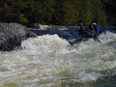
Butch, Mike & I paddled carefully down stream, aware that there is suppose to be a "river wide hole" somewhere in or near a gorge. After one false sighting we found not one but 3 river wide holes. One that could have been run if you had lived a clean life and Angels routinely clear your path. The other two where in the gorge, there may have been a sneak route but it would have been very dicey for our group. We hiked up and around the gorge, not a bad walk but not a walk in the park either. We put in looking down stream at something that looked a bit nasty but easily portaged. After scouting the nasty looking rapid, I believe it was Lava, Butch ran it with his usual grace and style while Mike and I walked our boats around, caught up to Butch and quickly floated to the confluence of the Ammo and the take out.
I really want to do this river again at a more reasonanble level. The gorge is runnable but it wasn't our turn to do so today. Lava clearly was runable.
Comments from Butch Nixon:
This was my first time to the Gale River below Franconia and a pretty river it is! If you choose to do it at high water, be aware that the rating of this river would increase by a full grade of difficulty from a 2-3-4 to a 3-4-5....The first difficult drop, Streeter Ledge, is mostly riverwide from what I could see while chasing swimmers and gear downstream. I would advise a full effort to stop and scout rather than a read-and-run on the fly as I did. After Chris and Erik left the river, Mike, Jeff, and I did a lot of eddyhopping, determined to not paddle blindly into the gorge. It was a good plan: the first drop did have a narrow line on the far left, but the consequences of going into this large recirculating hole looked like it could ruin your day, maybe your life. After a short pool, the river dropped through two strong riverwide holes in succession. A good day to walk the gorge! Downstream at the next big horizon line, Lava had some megaholes, but they could be avoided with a carefully chosen line. I agree with Jeff with wanting to come back to the Gale at lower water flows, hoping the gorge would be more runnable. AND that it would be more suitable for leading down a class 2-3 paddler! (Good effort, Chris!)
More info under the Flows tab
Rapids in this Run (4)
Difficulty
Class II-IV
Length
3.4 mi
Gradient
67 ft/mi
max 90
Rapids
4
Access Points
Difficulty Classes
I Easy
II Novice
III Intermediate
IV Advanced
V Expert/Extreme
VI Unrunnable
Current Conditions
5-Day Forecast
Whitewater data from
American Whitewater
American Whitewater