Gheils Road to Todds Fork
Gauge Conditions
Runnable: ? – ? CFS
Approximate reading: This gauge is 6.8 miles away on First Creek. Use as a general reference only.
Data from American Whitewater & USGS
Run Map
Run Time Estimate
Select put-in and take-out to estimate time.
Plan This Trip
See wind-adjusted speed maps, forecast planning, and detailed time estimates.
Sign in to generate an AI timing estimate for this run.
Whitewater timing varies with scouting, portages, and group pace. Use as a planning baseline.
Description
This run is a delightful and scenic Class II-III run. It starts off as a very mild class I stream for the first mile and a half, with two probable portages due to bad strainers. Chances of paddlers hiking and cleaning this creek are highly unlikely, so expect these trees to stay put for some time.
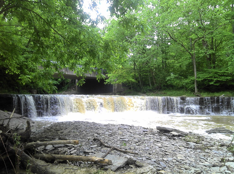
About a half mile after passing the first bridge, the creek finally starts to pick it up a little bit. When you see a gigantic mustard color mansion on river left, the first ledge appears. It's a small double ledge that is easily run anywhere. Not long after that, the first horizon line comes into view. This is the largest drop on the creek. Easily run with 3 or 4 fun lines, a sweet boof is located just left of center.
The creek continues with boogie water down to the next big ledge. When you see the next bridge, you'll know it's coming. A visible horizon line is apparent and you should have the line picked out ahead of time. This drop is the bad one you've probably already scouted while running shuttle. You've probably already decided whether or not to run it, too. There is only one safe way to run this drop, (other than sliding up on the right bank and pushing yourself over the ledge) and that is down a noticeable spout on river right. If you don't run it there, you're probably gonna spend some time in the hole. A ten foot log was seen on one occasion, doing cartwheels in the hole for over twenty minutes. Get your boof stroke on 'cause you're gonna need it. This is a good place to set safety if you're gonna try running this thing at higher levels.
The run is almost over. There is just a half mile of non-stop action with some small ledges and a couple of fun surf/play spots. Enjoy!
Waterfalls (1)
Difficulty
Class II-III
Length
2.8 mi
Gradient
40 ft/mi
max 50
Rapids
0
Access Points
Shuttle Info
The take-out is located just south of Morrow on Woodville Road at the confluence of First Creek and Todd's Fork. From there, head south on Woodville Rd. (stopping to scout the nasty ledge under the first bridge you'll cross) to Gheils-Carroll Rd. Turn right on Gheils and head to the first bridge. You can put in here on river left just upstream of the bridge, but you MUST Ask Permission. The homeowner is very nice, but do not take advantage of the situation. He allows access but we were told to please ask permission every time, and do not bring multiple cars and/or a crowd.
Difficulty Classes
I Easy
II Novice
III Intermediate
IV Advanced
V Expert/Extreme
VI Unrunnable
Current Conditions
5-Day Forecast
Whitewater data from
American Whitewater
American Whitewater