Gravel Bar to Chitina River to Copper River
No sufficiently local live gauge linked. 1 automated match was excluded because the closest is 38.3 miles away. Difficulty and route details are not current water conditions.
Run Map
Run Time Estimate
Select put-in and take-out to estimate time.
Plan This Trip
See wind-adjusted speed maps, forecast planning, and detailed time estimates.
Sign in to generate an AI timing estimate for this run.
Whitewater timing varies with scouting, portages, and group pace. Use as a planning baseline.
Description
Put-In Typically, parties fly from the Chitina airport into a gravel bar strip on river right about 8 miles south of the entrance to the canyon, using either Wrangell Mountain Air, Ultima Thule, or McCarthy Air Alaska. In addition, it is possible to land a float plane on a channel of the West Fork of the Tana, approximately 18 miles from the entrance to the canyon.
Take-Out The standard take-out is on the Copper River at O'Brien Creek on river right, which is 75 miles downstream of the Tana/Chitina confluence. The Chitina joins the Copper river 2.6 miles upstream of the O'Brien Creek take out. The Copper River comes in from the right and the confluence is notorious for high winds and huge unpredictable boils. It is recommended that boaters be prepared for trouble as they enter this confluence. Flips and swims are a dangerous possibility in the turbulent mixing currents. Wear your drysuits.
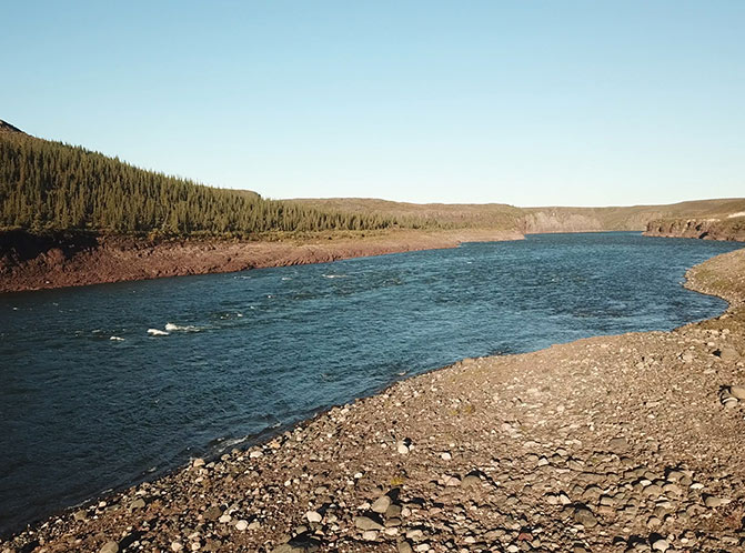
Description The Tana River is a tributary of the Chitina River, flowing roughly 36 miles from the Tana Glacier spilling off the Bagley Ice Field north to the confluence with the Chitina River. Whitewater on the Tana River is a source of a great deal of conversation amongst Alaska boaters. Tragic deaths early on earned the Tana River canyon a reputation that is a bit overstated. However, this is about as cold and remote as a North American whitewater river can be, and deserves a great deal of respect.
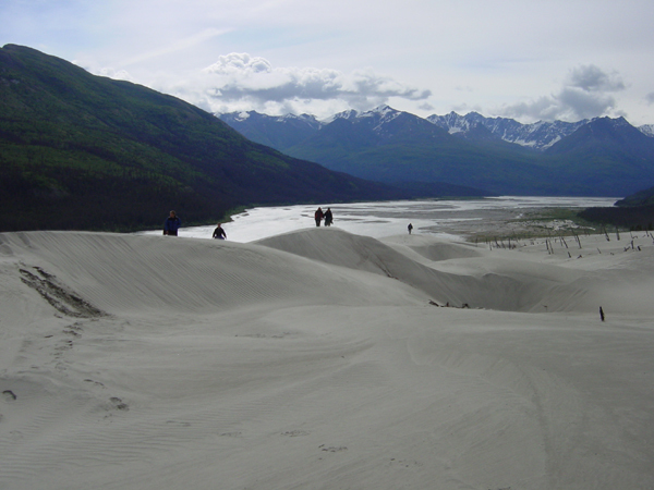
From the put-in strip, a fast float gains the entrance to the canyon, marked by a large dune set encroaching on a spruce forest on river left, above a huge shallow eddy. Camping below the dunes back in the protected trees is good for wind, bad for bugs, and great for hiking up the dunes for views of the Wrangell Mountain peaks.
Whitewater in the Tana River canyon can be characterized as continuous gradient class II-III cold-temperature big-water, with two drops pushing toward III+ - IV-. The total time it takes to run the canyon is a fraction of the trip length - about two to three hours. Rafts will be busy looking far ahead, and preparing to miss sticky holes and keeping their speed up to maintain forward momentum in the large wave trains. Kayakers have plenty of options to choose from in the wide channels, and can play on several large waves and holes. Scouting from the ground is tough, as the drops are long and the banks aren't very conducive to moving up and down. Scouting from the air is an excellent idea, but remember that the features will be much bigger at river level. Eddies are few, and can be unfriendly for both rafts and kayaks, with woody debris and funny water. Flipping a raft is a very real possibility. Swimming to shore would be very difficult due to the width and the swiftness of the river, the water temperature, and the lack of slack water between drops. Therefore, your best safety lies in a good drysuit allowing you to spend some wet time and avoid hypothermia, and a good partner boat to pick you out of the water.
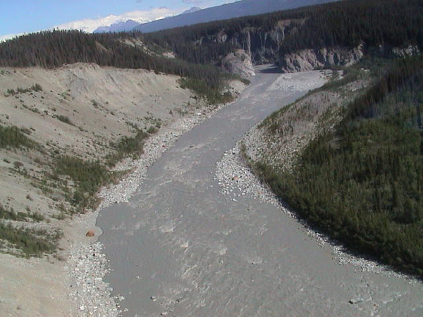
A large set of class II waves mark the entrance to the canyon. This is best run down the center for a fun ride, while being mindful of large holes on the right side. The river continues to pick up speed and meanders through a series of random class II big water style rapids. After the river splits into two channels around a gravel bar island, a clear water creek flows in on the river left side. This is a good spot to collect fresh water untainted with glacial silt. It also signals the beginning of the first notable rapid, a long, class III+ big water style drop. The entrance consists of hole dodging down a large wave train, and is known as Onramp. The river than takes a right hand turn, and enters the meat of the rapid, known as Freeway. The river right side is a shallow rock and gravel gradient drop, and the outside wall is a steep bank. The top of the drop is a straightforward wave train down the middle right, avoiding a big hole on the left that toys with 18' rafts . The middle of the drop contains a large rock that creates a huge hole at high water, and a pretty convincing barrier to travel at low to medium flows. Consensus seems to be cheat right as much as possible, then pull to the middle below the barrier rocks, and ride the wave train out.
Things pretty much continue as characterized with one exception - after a long, fast wave train, the river pushes into a river right wall. The reflection waves coming off the wall make for chaotic water, and have caused both good kayakers and rafters a bit of trouble in the past. The general plan seems to be pull as hard away from that wall as possible. Note that it is very possible to ram this wall with a lot of force.
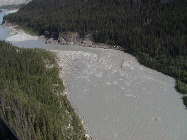
The canyon walls then recede, and class II-III rapids remain for another 5 or 6 miles. At one point, the river makes a lefthand owbow turn around a huge gravel bar. The outside of this bar is an excellent beach, and makes for a fine view camp. A couple of miles after this camp, the confluence with the Chitina River is reached.
After 75 miles the Chitina joins the Copper River. "The winds at the Copper river confluence and the strength of the river can catch you off guard. The locals said that the wind at the confluence is a pretty standard phenomena at the confluence. In addition to the wind, with the increase in volume comes some serious powerful boils in certain spots. One in particular was on the corner RR of the Copper confluence, I'm sure there tons. Because the weather was incredible, and the river was pretty calm the last few days we were not in our drysuits, next we will be!. WARNING: Boils at the Copper Confluence could easily flip a 16 foot boat and if one is not in their drysuits, they would assureadly be in a fight for their life because of the strength, and temperature of the water." (Moenkopi, 2011)
Additional Information Slackerdom.com has a trip report from 2002.
Wrangell-St Elias National Park & Preserve
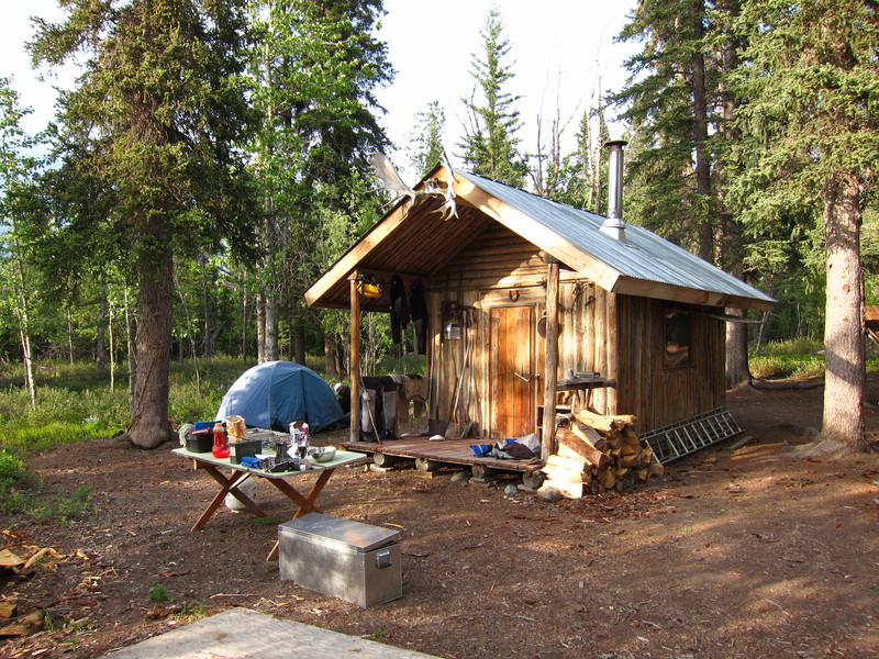
Jake's Bar cabins & airstrip
Moenkopi Riverworks trip blog from 2011
Rapids in this Run (6)
Hazards & Portages (1)
Caution: The following locations may require scouting or portaging. Always check current conditions.
Difficulty
Class IV
Length
99.0 mi
Gradient
14 ft/mi
max 25
Rapids
6
1 Hazard
Access Points
Difficulty Classes
I Easy
II Novice
III Intermediate
IV Advanced
V Expert/Extreme
VI Unrunnable
Current Conditions
5-Day Forecast
Whitewater data from
American Whitewater
American Whitewater